They say you don’t hike the same mountain twice.
It may be because of how mountains may show you different sides of it in different occasions. There may be a different weather. The trail may be drier or wetter. The plants may be in full bloom, or are still in the process of re-growing their leaves. The fauna may be less shy, and the forest more alive.
But what is inconspicuously implied about this saying is that you, as a hiker, may have changed as well. It may have been difficult for you the first time you climbed a mountain. But because of the wisdom brought by your first attempt, the strength it gave, the knowledge that it imparted, and the familiarity of getting to know the mountain for the first time, the second time allows you to navigate the course of the trail more easily and more confidently.
This was how I personally experienced Mt. Guiting-Guiting. I was blessed with an immersive experience taking the challenge of climbing one of the most revered mountain in the Philippines for the second time. This time, I took the challenge of climbing Guiting-Guiting with a better weather, a fitter body, and a calmer mind.
Ito and kwento ng aking ma-guiting na pagbabalik sa Mt. Guiting-Guiting (This is a story of my valiant return to Mt. Guiting-Guiting).
Mt. Guiting-Guiting?
Mt. Guiting-Guiting, standing at an elevation of 2,058 meters above sea level, is considered as one of the most difficult mountains to climb in the Philippines, owing to its technical nature. Unlike other mountains here in the country where one could just merely walk on a slanted path, Mt. Guiting-Guiting is classified as having a Trail Class 5, in which hands are used to climb up a very steep mountain slope. Moreover, it is one of the only few mountains in the Pinoy Mountaineer website as having a 9 out of 9 difficulty rating. The mountain’s challenging nature will surely test one’s physical and mental fortitude.
To get a glimpse of Mt. Guiting-Guiting’s history as a hiking destination, here is an excerpt from the Pinoy Mountaineer website:
Mt. Guiting-Guiting – fondly called G2 by enthusiasts – was discovered as a mountaineering hotspot during the early 1980’s – an exciting period for Philippine mountaineering, when the novel sport has just begun unravelling new and exciting destinations. In May 1982, a combined team of the Philippine Mountaineering Society (PMS) of Bacolod City and UP Mountaineers did the first exploration of the mountain, reaching the then-unnamed Mayo’s Peak but failing to reach the summit. A few weeks later, some of them returned to make the first ascent to G2’s summit. They were Mon Ruiz, Kim Valino, Bubot Tan Torre (UP Mountaineers) and Edwin Gatia of the PMS.
Since then, Mt. Guiting-Guiting has become the goal of every Filipino mountaineer.
Another amazing attribute of the mountain comes from its location. Sibuyan Island, where Mt. Guiting-Guiting is, is dubbed as the Galapagos of Asia, owing to the endemicity of the flora and fauna found in it. This means that there is an abundance of plants and animals only found within the island and can never be found anywhere else in the world, including the rest of the Philippines. This entails the conservation and protection of the island from illegal and destructive activities.
Prelude
My second climb to Mt. Guiting-Guiting took place in March of 2024 – summer season had just begun in the Philippines and was worsened by an impending El Niño phenomenon. Still, I thought it was a perfect time to climb up the mountain as, often, it gets covered in rainclouds all year round, just like in my previous experience climbing Mt. Guiting-Guiting. If you will read my previous blog about my climb in Guiting-Guiting, you will see that for the entire three-day hike, we were met with gushes of howling wind and we were soaked with incessant rain. I was hoping that for my second time, the weather would be nicer this time around.
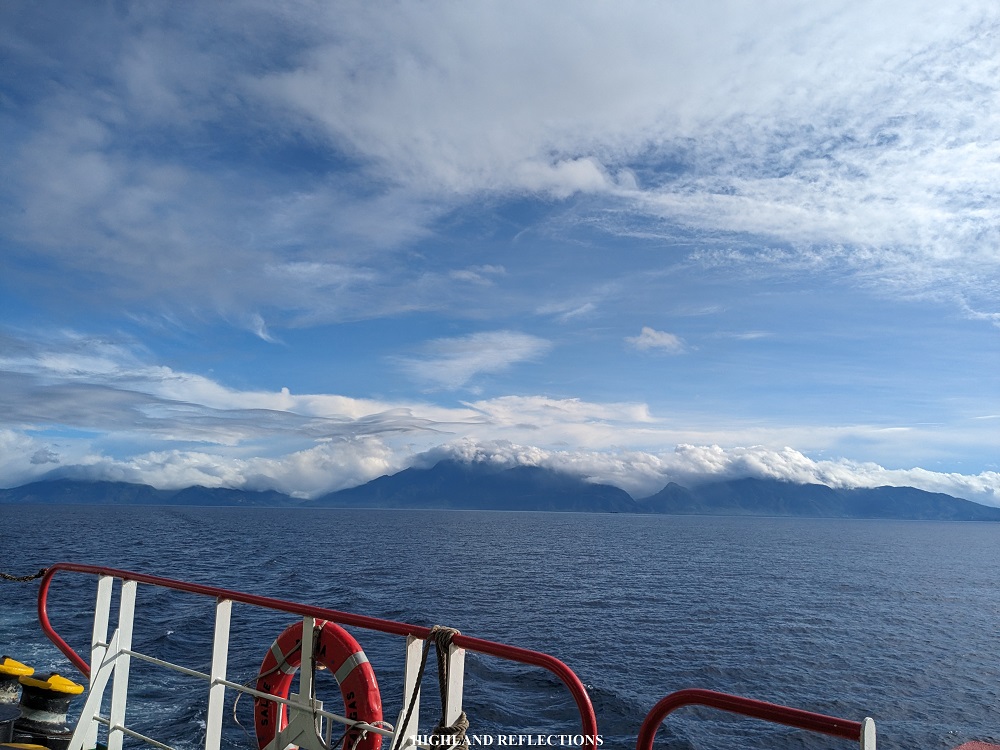
My adventure started in Batangas City, where I and my companions for this climb boarded a Starlite Ferry to take us to Sibuyan Island in the Province of Romblon where Mt. Guiting-Guising is located. We left the coast of Batangas past four in the afternoon.
During our 12-hour trip to Sibuyan Island, I was able to acquaint myself with the rest of the team, consisting of Ryan, the organizer (Facebook page: KUYA RY Travels), and his team of friends, Caloy, JM, Jesslin, Eca, Tala, as well as Elle, and her Singaporean friend, Crystal. I was able to join Ryan’s organized event after scouring on Facebook for a team that would climb Mt. Guiting-Guiting a week before the Holy Week break in the country. The Holy Week holiday is when an influx of hikers would crowd Mt. Guiting-Guiting, hence, why I scheduled my hike a week prior to avoid them. Good thing was that we were the only team to take the traverse during our stay in the mountain!
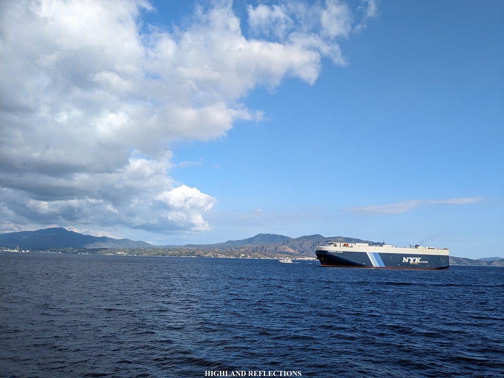
Aboard the ferry, we spent the late afternoon at the starboard, idling and watching the waves of the sea, and admiring the mountains along the Batangas coast. We also spotted what is seemingly a gigantic mountain being dressed in clouds in the southern direction, in what we can only assume as the venerable Mt. Halcon in Mindoro, another mountain that is in the same tier as Mt. Guiting-Guiting in terms of difficulty, which we have to hike soon once it re-opens!
I spent the entire twilight reflecting. I was at the verge again of doing one of the most difficult hikes in the country. My entire soul, pumped with adrenaline, was ready. Still, I needed some rest. I retired for the night. After having some dinner and social sessions with the rest of the team, I slept soundly in my bunker.
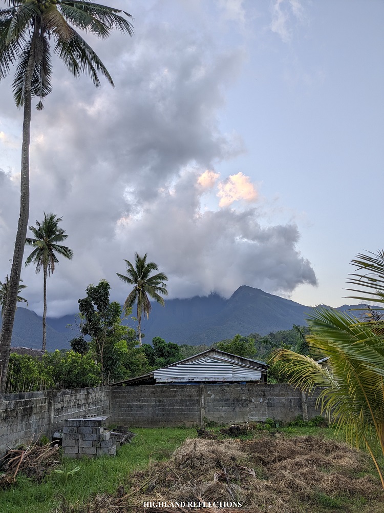
We reached Sibuyan Island past four in the morning. We were welcomed by our guide, Alexander Arbis, who had already prepared the necessary documents for our climb. We went to his home near the jump-off point in Barangay Tampayan in Magdiwang, where we left our bags to have some breakfast in the town proper. Afterwards, we had an orientation at the park office of Mt. Guiting-Guiting a few kilometers away from the jump-off point. We returned to Kuya Alex’ house and had our much needed baths.
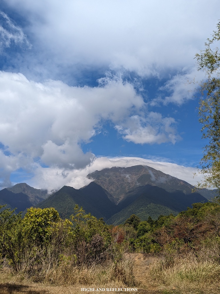
At 11 in the morning, we started the hike. Mt. Guiting-Guiting was smothered in clouds.
Day 1: Into the Forest of Magdiwang
We started the hike a bit late. The midday sun was bathing us all over with his sunlight. Good thing was that in no time, we entered the thick rainforest of the Tampayan Trail of Mt. Guiting-Guiting, where we crossed three streams that were a bit dry before taking up the nonstop ascent inside the forest. Given the atmosphere’s temperature, I made sure to take up the ascending trail slowly and gradually so as to avoid overheating and getting cramps. The atmosphere was quite dry and there were no gusts of wind inside the forest. We reached Camp 1 after an hour. There, we took our lunch.
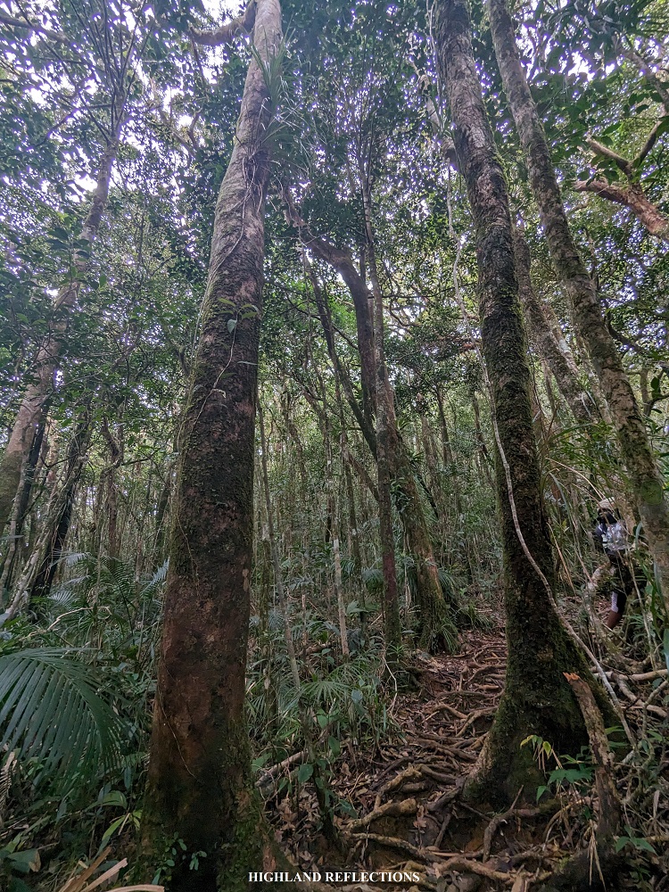
We pushed through going to Camp 2 after our lunch, where it took us an hour of nonstop ascent. Then, after resting at Camp 2, we pushed incessantly going to Camp 3, with some five to ten-minute rests to eat and hydrate. Once we reached Camp 3, we munched on some trail snacks some more to recuperate. It was honestly an enjoyable experience hiking up the rainforest. During my first time in Mt. Guiting-Guiting, which happened 15 months prior to this hike, I was exasperated climbing on our first day as a I came from work and had a lack of sleep prior to our hike. For this second hike, perhaps my preparations and my complete sleep while in the ferry were all coming into fruition, as I was able to optimally immerse myself with the forest bathing that I was in.


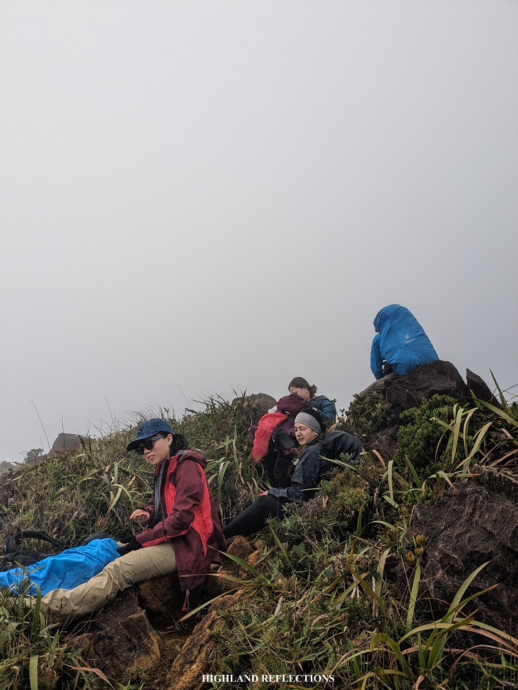
Past Camp 3, we refilled our water bottles in Bulod’s Spring. The water trickling on the mossy rocks were almost nonexistent. Our guides patiently fetched water from a tiny stream in between the boulders. As we were refilling our water bottles, it rained. I soaked myself with the sky’s blessing and continued pushing to Mayo’s Peak, the end point of our first day.

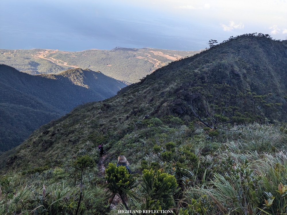
The last stretch of rainforest was marked by a pine tree at the side of a ravine facing the mountainside of Mayo’s Peak. The entire surrounding was enveloped in thick fog, battering us with strong gusts of wind as we took some rest at the side of the dwarf pine tree. Past the pine tree is the last stretch of steep assault going to the peak, which was surrounded by shrubs and grasses, and is a foreshadowing of the trail that we have to face the next day.
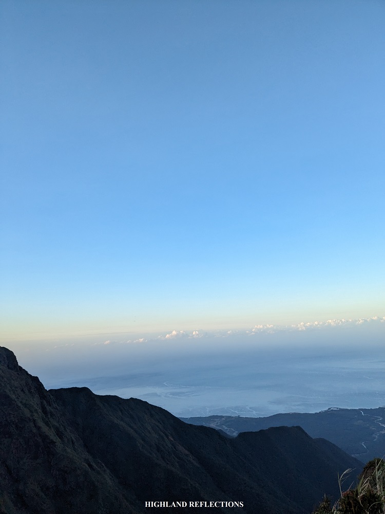
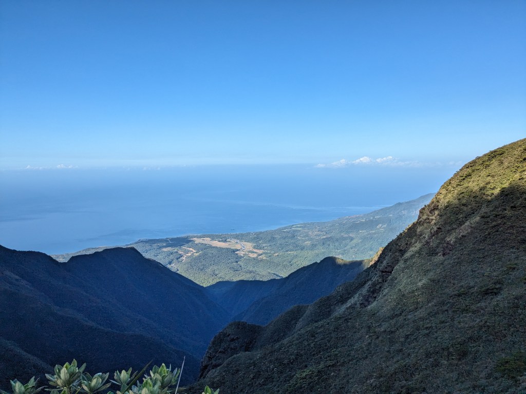
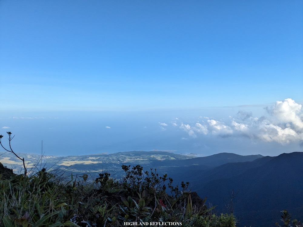
Thankfully, as we were taking the last portions of the trail going to Mayo’s Peak, the sky cleared up for a bit, and we were able to appreciate the Magdiwang side of Mt. Guiting-Guiting and the sea below. The setting sun’s rays were also visible in the western direction, marking the end of our first day of this adventure.
We pitched our tents at the swampy area of Mayo’s Peak. That night, it was cold and windy. I hoped for a better weather for the next day.

Day 2: Rock Climbing Galore
It was past four when I woke up. Darkness was still surrounding the entire campsite. However, I could see some stars above us, indicating that it would be a good day. I was desperately hoping for a clear weather.
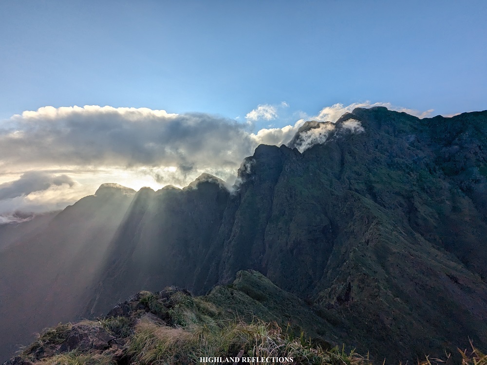
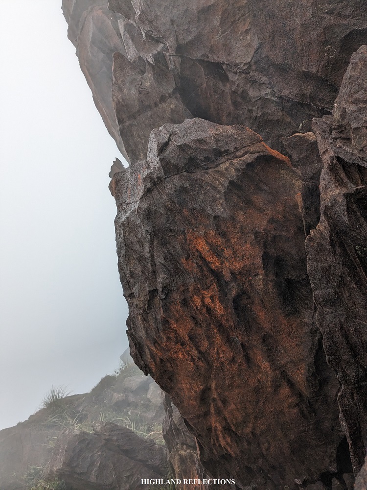
After taking our breakfast, we broke camp and went on to the view deck of Mayo’s Peak. As we emerged from the mossy forest of the campsite towards the view deck, I saw for the very first time the titanic mountain wall containing Mt. Guiting-Guiting’s peak. It was like an entire separate mountain in itself! It was honestly an intimidating and amazing experience seeing the peak dwarfing the range surrounding it.
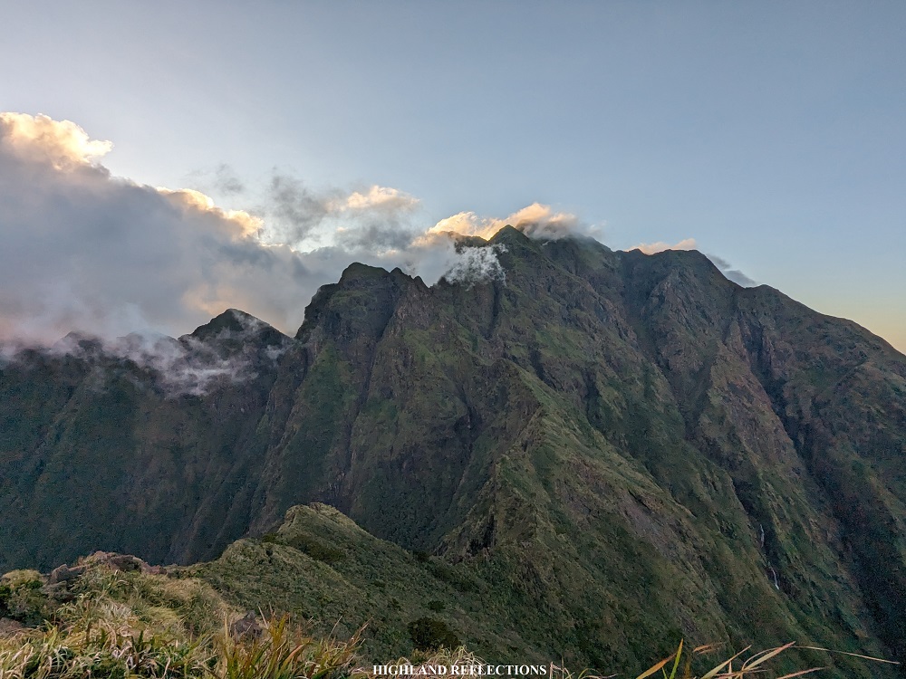
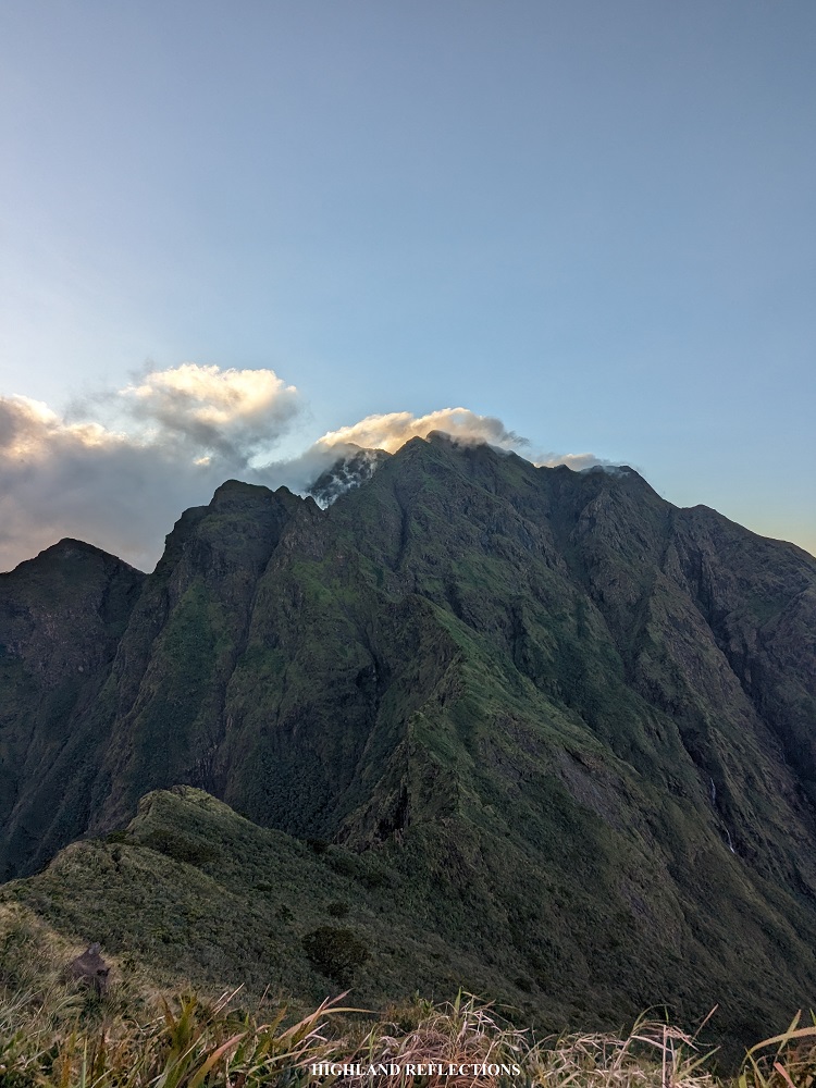
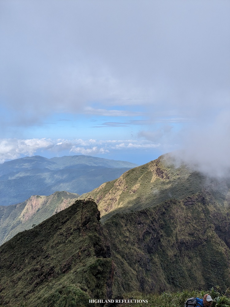
Complemented by this gigantic mountain wall in front of us are the sawtooth peaks of Mt. Guiting-Guiting. They say that its moniker ‘Guiting-Guiting’ came from a local word which meant jagged, alluding to the sawtooth-like crests at the side of the summit. What made the view all the more captivating was the sun’s rays, piercing its way through in between each jagged crest. It was such an awe-inspiring scenery, a perfect way to energize us to start our day.
Another wonderful sight is the knife edge ridge connecting Mayo’s Peak to the base of the mountainside wall of the summit. The lengthy ridge meanders like a snake, discouraging those who would want to push through going to the summit, as hikers would need to pass through thin ridges akin to that of a knife’s edge (hence, the name). The trail was only for the dauntless, and dauntless we were!

I couldn’t contain my smile seeing these alluring views in front of me. It was absolutely breathtaking! I couldn’t even stop myself from snapping some photos of the picturesque view. Did I say that it was breathtaking? If I already did, I apologize – the mountain view, complemented by the cerulean sea surrounding the island, was just THAT beautiful!
Of course, we needed to get going to get to the goal of the day – the summit, and beyond it, the campsite at the opposite side of the mountain. We started the day’s hike with a 100-meter descent. Given the steepness of the trail, it didn’t feel like a hundred meters at all! The length of the descent felt like it was a good three or five hundred. What made the descent quite difficult besides the steepness was that the entire trail was dotted with ultramafic boulders which we had to crawl our way through. It was a dangerous predicament. One miscalculated step would lead you rolling down the slope of the mountain.
After a few meters of continuous descent, we encountered the Eagle Rock, which was a protruded boulder at the side of a ravine. The park management of Guiting-Guiting have now prohibited hikers to climb up the rock as it can lead to a sharp fatal fall.
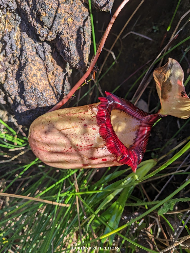
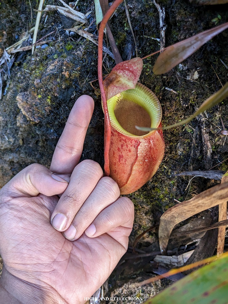
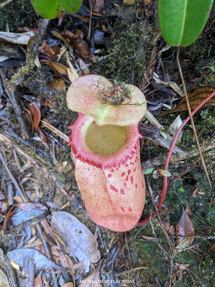
Past the Eagle Rock, the knife edge trail continues, which required us to pass through a flora-filled ridge where we were able to spot some pitcher plants. Some of these, such as the Nepenthes sibuyanensis, are endemic to the island. Along the knife edge trail, we also encountered some boulders here and there, requiring us to make acrobatic movements to push through.
During the entire climb up to the summit, I was with Crystal, our Singaporean companion, who also happens to be a rock climber. We were leading the group, as both of us seem to be in our flow crawling on dangerous rocks along the knife edge trail. It was as if two madmen were in their killing zone and making this their vicious playground.

After two hours of total nonstop action, we passed by the Camelback, which was a steep crest marking the end of the knife edge trail. Past the Camelback, Crystal and I rested and waited for our companions at the base of the mountainside. We exchanged some stories and our thoughts on the climb. We only had one word for this treacherous undertaking – enjoyable.

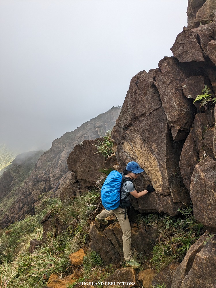
We continued with the next portion of the hike upon the arrival of our companions, which was climbing the mountainside wall all the way up to the summit. Fog now caught up to us. We meandered our way through the mountainside, passing through via a horizontally carved trail on a steep slope. Then, I encountered once again one of my favorite portions of the trail – the Kiss the Wall!
With its intimidating name, the Kiss the Wall is a part of the trail in which one would need to traverse a very narrow path obstructed by a mountain wall. Although it’s not as dangerous as the name implies, it could still lead to a fall at the side of the trail if we made a miscalculated step. To pass the trail easier, we needed to use our hands to hold on to the carvings of the boulder wall, and plant our bodies onto the wall so as to not fall. Given that this was my second time taking the Kiss the Wall, it was easy peasy.
A short steep ascent ensues past the Kiss the Wall, leading to Mabel’s Spring, the only water source along the trail. There were two small trickles of water in the area, which we used to refill our water bottles. We took some rest.
Past Mabel’s Spring, Crystal and I encountered a continuous steep ascent. We took this slowly but surely, as expediting it may lead to over exhaustion and cramps. Along the upper portions, we had to brave our way through numerous boulders. Climbing them felt like solving a puzzle. Every step of our feet and every grab of our hands felt calculated. Still, I was in my element. Tiredness was kicking in but I was enjoying every bit of it.
Exasperated but hopeful. Weary but engaged. These were all the feelings that were mixing inside of me as I took the very technical portions of the trail. It did feel like we were now climbing a wall given the steepness and the intense technicality of the climb. This was, in my opinion, the most difficult portion of the entire ascent. Past 11 in the morning, we reached Peak of Deception, all covered in thick fog. This peak fooled the first explorers of Mt. Guiting-Guiting, mistaking it as the summit after the arduous climb, only to find out a higher slope upon reaching it.
We rested for quite a bit at the Peak of Deception after that tedious climb up. After resting, we continued. There was a little bit of descent past the Peak of Deception, but continues up a steep wall afterwards, where the continuation of the very technical rock climbing parts resumed. After some thirty minutes of steep uphill battle, I encountered a familiar friend. I immediately recognized it – the 90-degree wall!
I remember how I felt climbing this portion during my first time in Guiting-Guiting. I was so exasperated with the climb back then that my body felt like it was giving up on me. I surrendered my bag to the guide so as to lighten up my weight climbing up the almost 90-degree pass.
But this time, I faced it with confidence and vigor. I was carrying with me my backpack climbing up a very steep boulder prior to the 90-degree pass. Upon reaching the bottom of the pass, I immediately started the climb up. With the instruction of our local guide, I climbed up with relative ease thanks to my previous experience. It sounds like it ain’t that much, but for me, it was an accomplishment of a lifetime!

Honestly though, the pass doesn’t seem like it’s entirely a 90-degree vertical. However, if you have a a drone and you take some aerial shots of the view, that’s when you’ll realize that the entire surrounding is indeed a 90-degree cliff!
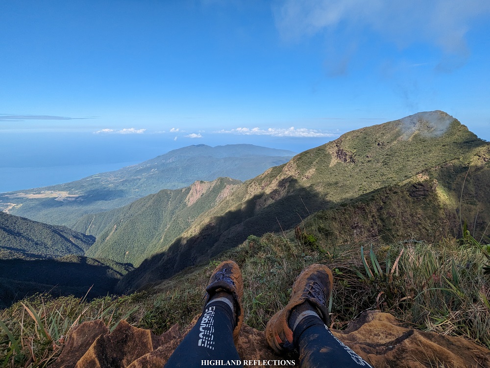
The 90-degree path marks the entrance to the shoulder of the mountain. From there, we could already spot the summit due to thinness of the fog surrounding us. It looked very far, but I was sure that it will only take around 15 minutes to reach it, passing through some flat sections at the shoulder of the mountain, and then some short ascents before the summit. As I was walking along this portion, called the “Walk of Fame”, the clouds danced around the summit, clearing up the sky and giving me a picturesque view atop the mountain. I hurriedly went up to the summit.
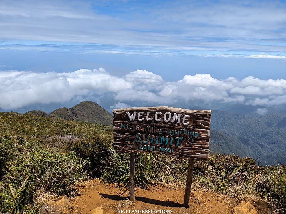
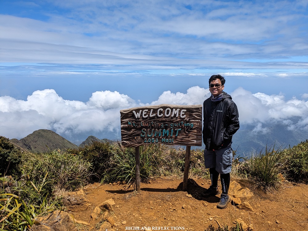
At around 12:20PM, after more than five hours of climbing up, I finally reached the summit of Mt. Guiting-Guiting! Another accomplishment secured! With the clear view on top and the remaining strength residing in my body, I was able to avenge my 2022 self who was battered with rain and slowed down by body pain upon reaching the summit of Guiting-Guiting.
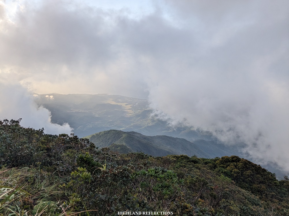
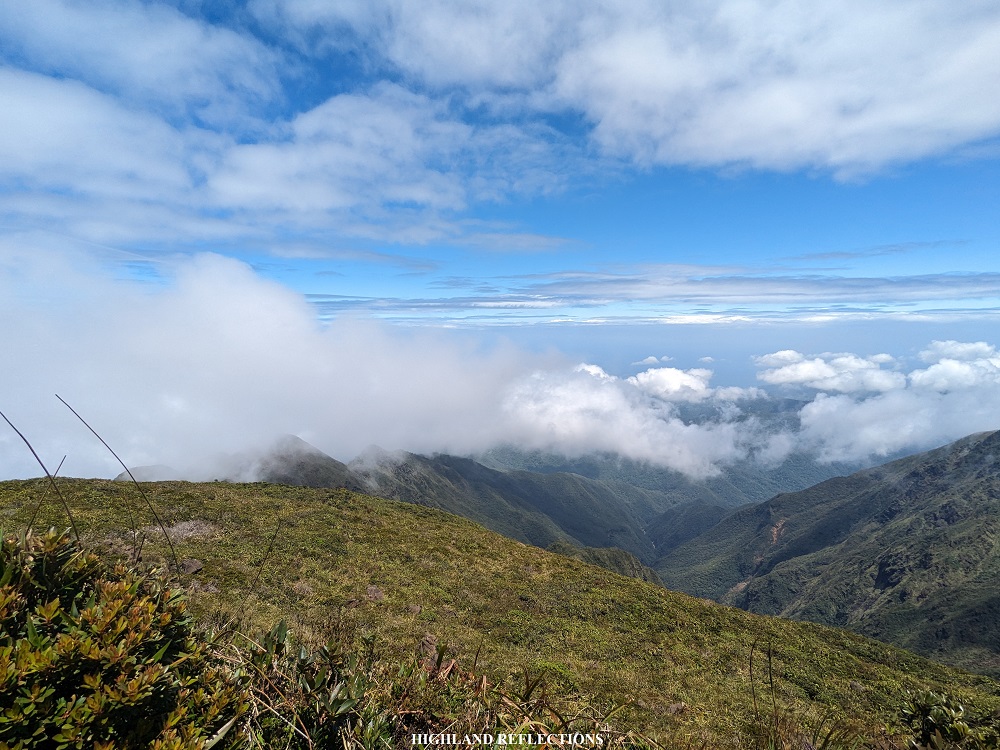
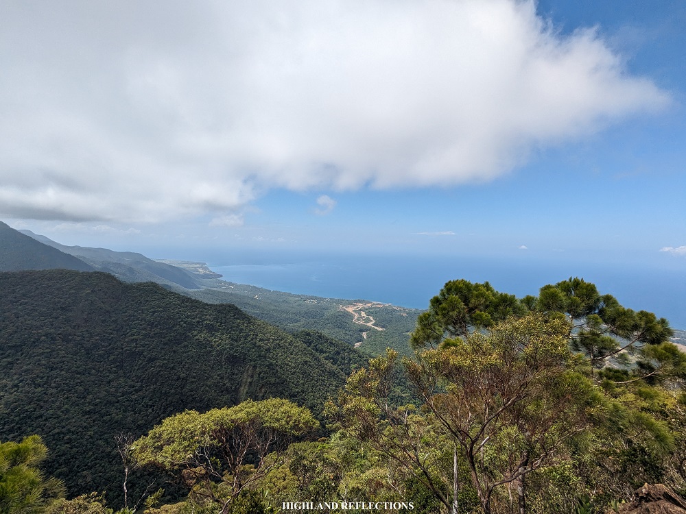
I thanked the heavens for such a beautiful weather at the summit. Although there was still fog in the western portion of the summit, the eastern portion gave off a clear view of the surrounding mountain slopes of Guiting-Guiting. This was complemented by some fragmented clouds surrounding the entire summit area. As the clouds were quite playful during our stay at the summit, we would sometimes get a view of the sea surrounding the island, but sometimes, the clouds would completely cover the summit, blocking off any possible view.
With the beautiful vista that the summit provided us, Crystal and I helped each other in taking pictures at the summit marker before it was once again enveloped in thick fog. We also took our lunch at the summit. Upon the arrival of the rest of the team after an hour, we exchanged stories of our clear views. While Crystal and I were enjoying the clear view at the summit, the rest of the team were able to have theirs at the Peak of Deception, where they able to see the jagged peaks of Guiting-Guiting up close!
As all things that go up must come down, so too our able bodies at the summit of Guiting-Guiting. We started the descent via the Olango Trail past two in the afternoon. Leading the way, we navigated another round of boulders, but this time, it was less steep and technical. Still, I was a bit exasperated. I tried to slow down even more to accommodate the newness of the movements that I was making, which was all downward.
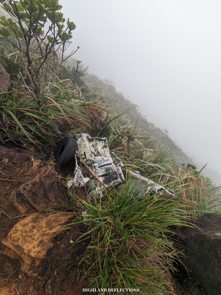
I tried strengthening my mental fortitude going down. Although I wanted to run on the trail, I knew my legs were a bit spent from the climb we just did and the moderately heavy pack I was carrying. After more than an hour of infuriating descent, we reached the Crash Site, where the remnants of the Britten-Norman BN-2A-21 Islander plane are scattered around the grassy slopes of the mountain. Our guides said that these pieces of airplane junk have been repurposed to be displays along the trail.
Past the crash site, our lead guide left us to set up our campsite, which was located at the Camp 3 of the Olango Trail. Since there were only a few technical portions, and the trail was just a straightforward descent, we carried on and continued without our guide.
It rained as we were descending. I managed to advance alone on the trail, leaving my companions behind. From there, I could already spot some of Guiting-Guiting’s low peaks at the southern side of the mountain. After covering some exasperating distance of descent, I encountered a very technical portion in which the trail is carved on a boulder that slants on a 5-foot ravine. The boulder was quite slippery, and I knew very well that it needed some rope to assist hikers. But since there was no rope to hold on to, I tried braving that part of the trail alone. I tried climbing down backwards, which was how I usually go down a sharply steep trail. But alas, my foot slipped, and I was hanging on the slanted boulder. With my core strength, I hugged the boulder as I was slowly falling down, negating the impact of my fall onto the next portion of the trail. Disaster averted!
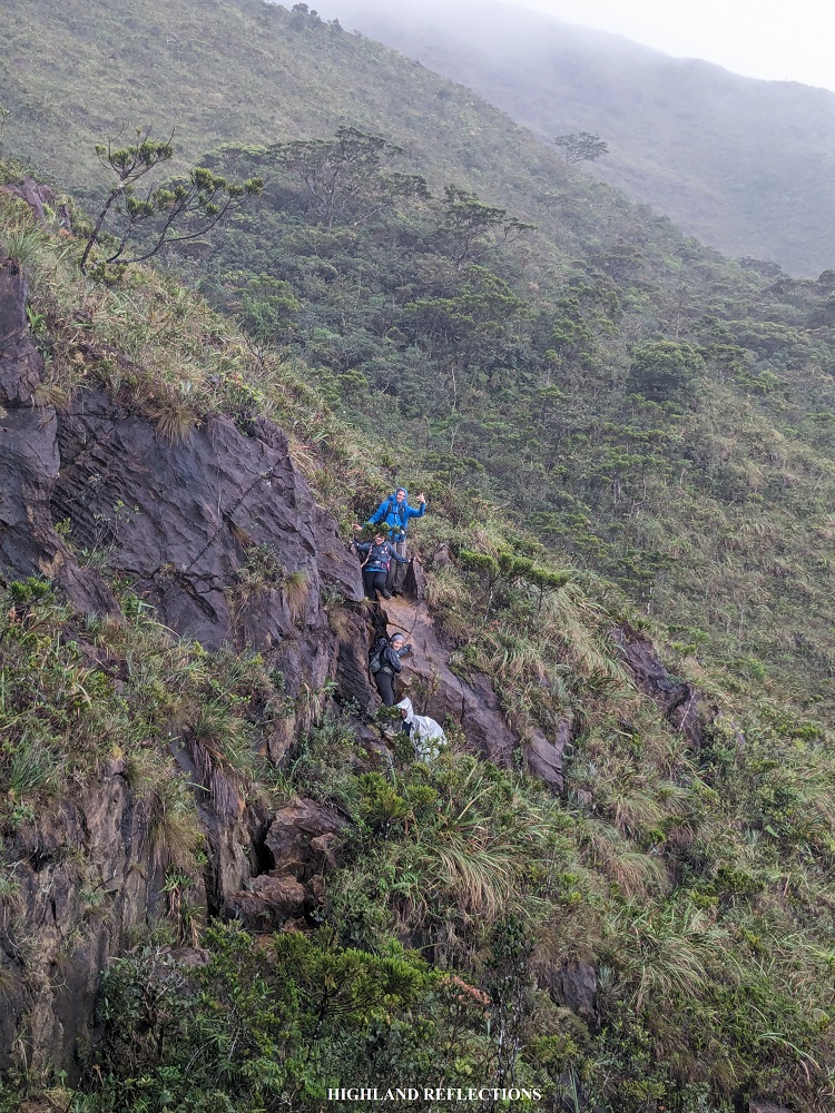
I tried pushing forward and stopped at a portion of the trail where I could have a view of the technical portion from afar. From there, I waited for my companions so that I could watch them in case something bad happens. Since they were all very able hikers, I just took some photos and videos of them as they were making their way down.
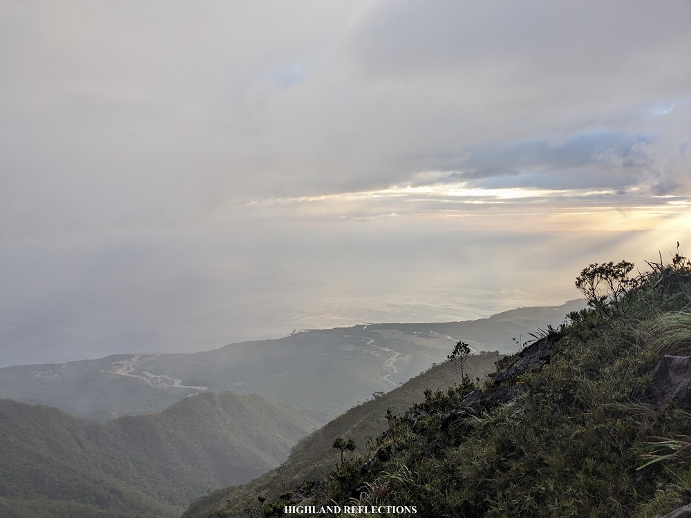
The descent continued. This time, we were close to one of the low peaks that I spotted earlier in the trail. As we were nearing it, the sky cleared up, and we could see the setting sun along the horizon of Sibuyan Sea. Past six in the evening, we finally reached Camp 3, which was a flat ground inside the mossy forest of a small crest within the mountain range.
What a long day! Indeed, the second day of every 3-day Guiting-Guiting hike is always the most difficult. It was a day of total nonstop action!
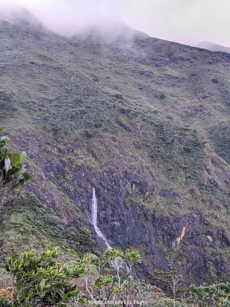
That night, we had our dinner. I wasn’t able to get a sound sleep as it was raining in the campsite. The gushing of water made me think that it was raining heavily, only to find out the following day that there was a nearby waterfall near the campsite.
Day 3: The Painful Conclusion
I’m not gonna open this up with anything inspiring. Descending the Olango Trail, in my opinion, is one of the most technically difficult portions of the entire hike. Still, it’s part of the Guiting-Guiting experience. It wouldn’t be Guiting-Guiting if it wasn’t difficult!
We started our day around eight in the morning. The sun was up, illuminating a great portion of the island. As we were starting the descent from Camp 3, we were able to spot a waterfall formed on the slopes of the gigantic mountainside wall near the campsite. Along the descent, Crystal, Elle, Eca, and I exchanged some stories, while Caloy and Tala went ahead. This allowed us to pass the time as we were spending some long minutes on the descent. We were also stopping by a lot since there was such an abundance of pitcher plants, with different shapes and sizes, along the trail! Eca and I were taking a lot of photos of the pitcher plants.
We reached Camp 2 after an hour of continuous descent. The camp was in the middle of a mossy forest, and was wider compared to Camp 3. The gang decided to take some short water break rest. Then, Eca and I advanced, leaving the rest of the team behind.
The trail past Camp 2 was one of the most tiring portions of the hike. The trail runs on a narrow ridge inside the forest, dotted with large boulders which we had to pass by making monkey-like swinging movements and making careful steps so as to not to fall on some of the potholes produced by the rocks. Other times, we had to brave through some 70 to 80-degree walls to climb down. Eca and I decided to pass the time by exchanging stories.
As we were nearing Camp 1, the trail got steeper and steeper. Although dressed in some canopy, the trail was exposed to the heat of the sun, which made the descent all the more tiring. Fortunately, we had a view of the entire surroundings. It helped in alleviating the tiredness for quite a bit.
At 11 in the morning, Eca and I reached Camp 1. We munched on our remaining trail food to replenish our energy coming from an arduous descent. While we were resting, the team caught up with us. We decided to go down together and cover the remaining distance past Camp 1, which was now less steep compared to the previous trail. Still, with the heat of the midday sun and the continuous descent, we had two rest stops along the trail to recuperate.
We finally exited the forest of Guiting-Guiting past twelve noon. We emerged onto a grassland plateau with a lone tree in the middle. We rested for a few minutes there before continuing the descent to Olango River, where Caloy and Tala were waiting. The waters of the river were not that deep compared to my previous experience. There, I took the chance to clean my legs and shoes.
Caloy, Tala, and I decided to go ahead and cover the remaining three kilometers of flat trail inside the forest. We power walked the entire trail. With my tired body, I reached the exit point past two in the afternoon. Looking back to Mt. Guiting-Guiting, I let out a sigh of relief for finally finishing the hike. We went to the house of the head guide of the Olango Trail to have our bath and eat our lunch.
After that three-day hike, I bade good bye to my companions for such an awesome experience. They were set to go to Cresta de Gallo after the hike. Since I’ve been to Cresta de Gallo, I decided not to go there and instead, have my side trip in Roxas City in the Province of Capiz, which was a 5-hour ferry ride from Sibuyan Island. Since the ferry was scheduled at 5 in the morning of the next day, I could not afford to join the rest of the team for their side trip. I spent the night in Sir Alex’ house before catching my ferry to Roxas the next morning.
Epilogue
As I was aboard the Starlite Ferry en route to Roxas City, I once again marveled at Mt. Guiting-Guiting from afar, with its summit still covered in thick puffs of rain clouds. My sleep-deprived body was honestly tired at that time, but my soul felt accomplished and proud.
Just like my other favorite mountains in the Philippines, I promised to Mt. Guiting-Guiting that I will be returning to witness its beauty time and time again. Regardless of the weather or the trail combination, or the number of days it will take me to climb its summit, or whether I’ll be alone or with friends, one thing is certain – I will surely revere it every time I go back!

Hi! Do you happen to have maps/routes that you followed for this? Thanks!
LikeLike