As I was walking alone in the midst of a forest whose land has witnessed the many faces of our times, I kept wondering what was going on in the mind of a 23-year old general whose fate was about to end upon reaching this highland. Conspiracies crept inside my head, of whether he was deceived by the infamous general who ordered to kill his fellowmen. As I was treading this lonely place, I can hear the crawling of a snake on the bushes by my side, which was later seen by our tour guide walking a few meters behind me.
This was a trip full of reflections and wonderings. I was at Mount Tirad.
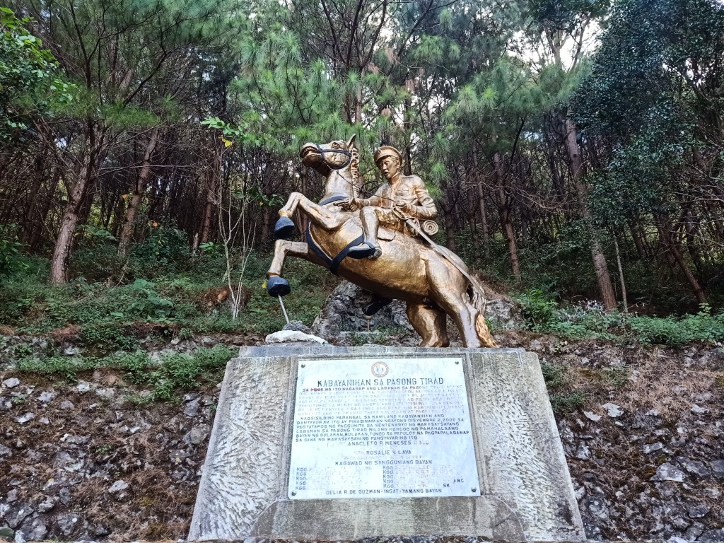
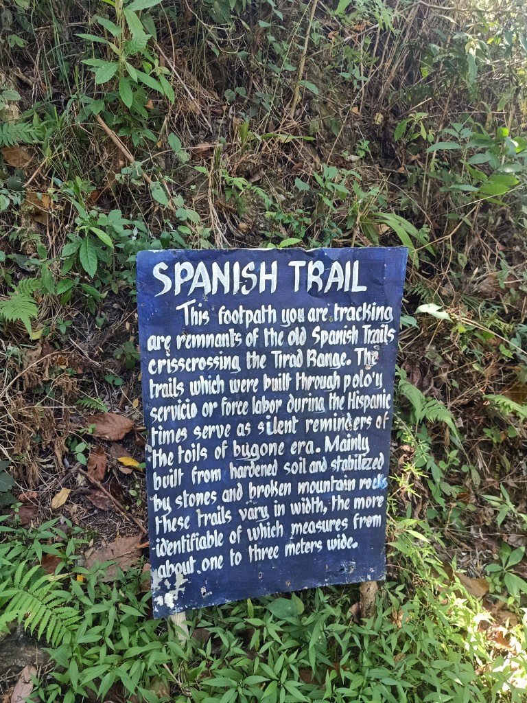
Last 22nd and 23rd of February, 2020, our Chill Trekker team scaled one of Ilocos’ prime hiking destinations: Mt. Tirad. Situated in the quiet and humble town of Gregorio Del Pilar (GDP) in Ilocos Sur, this place is filled with history, as it witnessed the Battle of Tirad Pass where the young Bulakenyo general, Gregorio Del Pilar, fought American forces who were hunting down Emilio Aguinaldo. Del Pilar’s mission was to delay the American forces and let Aguinaldo escape through the Cordilleras. On December 2, 1899, the American troops successfully defeated Del Pilar’s battalion on the slopes of Pasong Tirad (Tirad Pass) with the help of an Igorot villager who informed the Americans about the topography of the mountain.
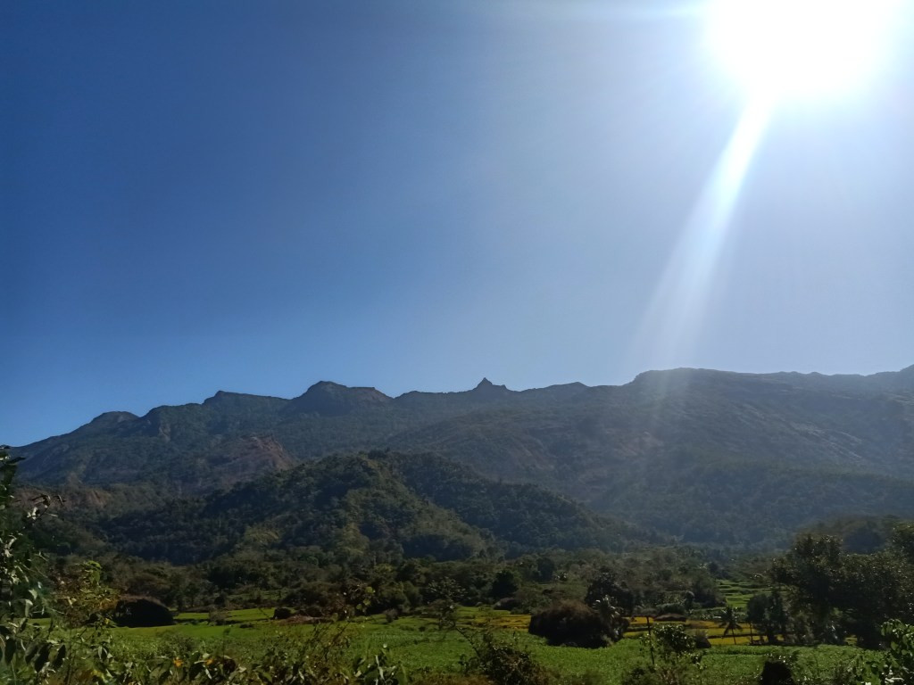
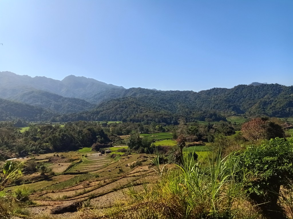
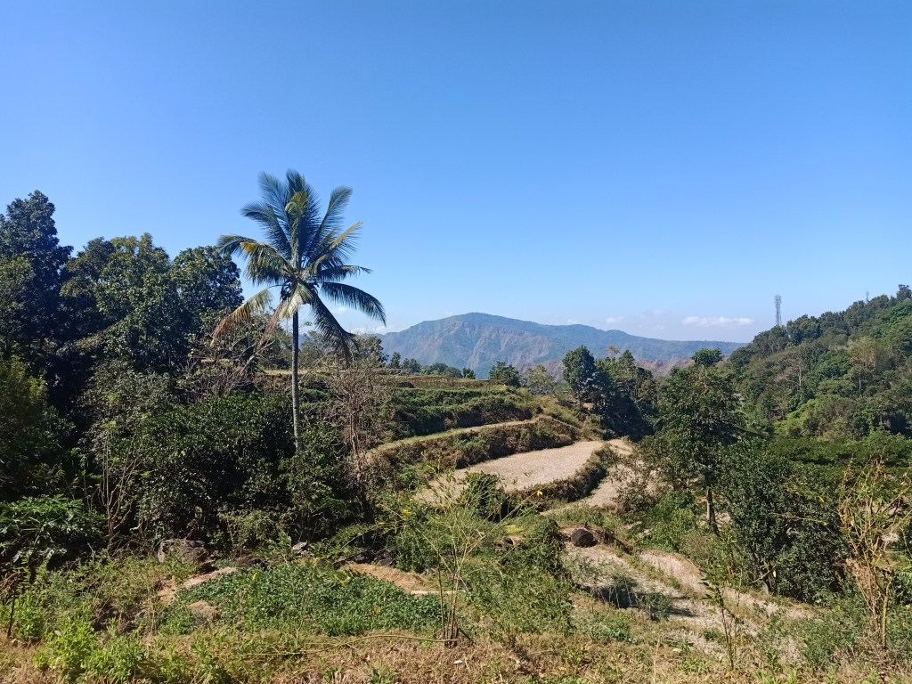
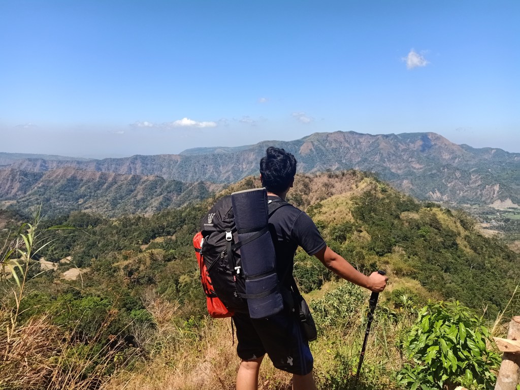
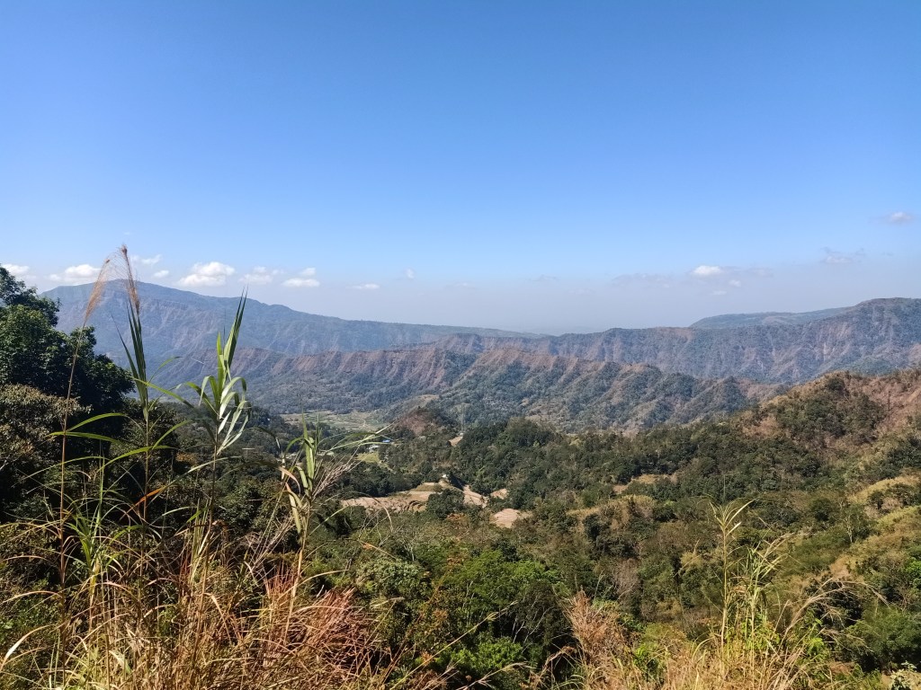
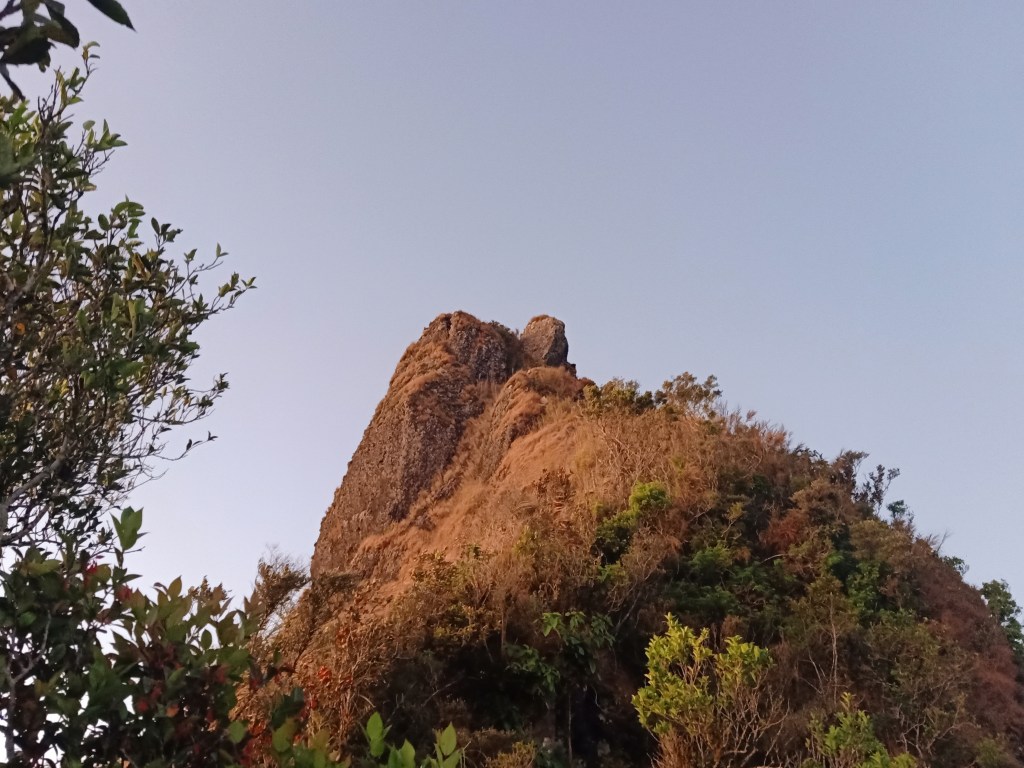
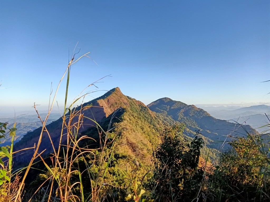
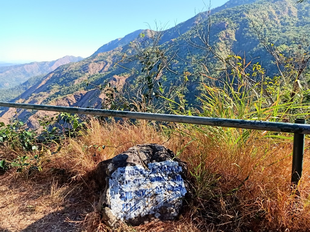
Speaking of topography, the mountain range of Mt. Tirad can be considered as a gateway to the Cordilleras from the west. When coming from Candon, Ilocos Sur, the fields of land near the sea transforms into layers and layers of mountain slopes, spanning the towns of Galimuyod and Salcedo, with heights spanning from 400 to 1500 MASL. Valleys would be observed around the area; the mountain ranges are still partitioned and not connected unlike the mountain ranges inside Cordillera. With the many peaks of the mountain range, we scaled one of the highest dubbed as “Tirad Peak” (1388 MASL), a pointy monolith that can be reached from the Tirad Pass Shrine.
For this hike, I met with the team at our usual rendezvous point at McDonald’s Greenfield in Shaw Boulevard. There, I re-acquainted myself with Jaayem, the head of the group; Dandy and Jay with whom I have shared many hikes in the past; Emil, who was present at our Ulap, Malipunyo, and Timbak-Tabayoc climbs; Anghie and Noriel who I both met two years ago at our intense day hike in Mt. Irid, and other regular peeps of The Chill Trekker. Our van set course for Candon, Ilocos Sur starting at twelve midnight of February 22. I had a good night’s sleep for almost the entire ride, broken only by our stopover at Leeza’s in Sison, Pangasinan past three in the morning. There, I ordered my usual tocilog coupled with a soup. Afterwards, we continued our ride towards San Fernando, La Union where we picked up another joiner. I was asleep again for the most part of the ride, but as we entered Ilocos Sur in the town of Tagudin and with the sun slowly illuminating the sky, I laid my eyes on this new scenery. It was my first time to be in Ilocos and I made sure I would get a mental picture of that moment. After a few hours of seeing fields of green and mountainous slopes in its background, we reached the town of Candon at six in the morning, where our jeepney service was waiting for us to take us to GDP.
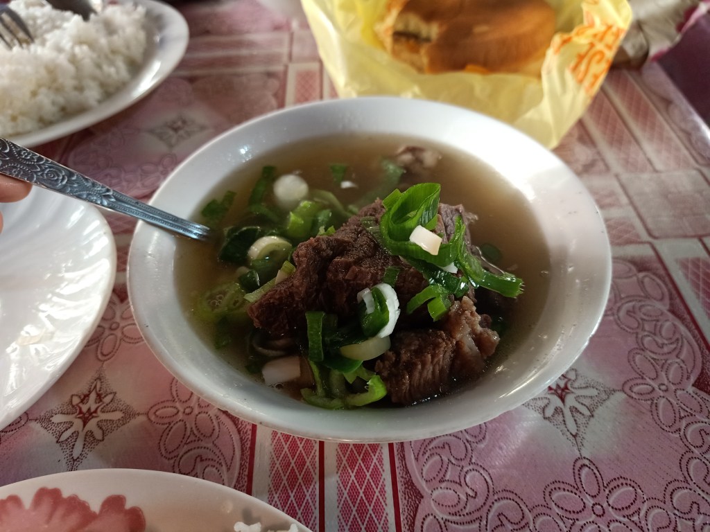
Before going to GDP, our jeepney driver took us at a local eatery in Candon. There, we ordered a local dish called sinanglaw, a thick and greasy breakfast soup made from boiled beef and beef innards. I was perplexed with the thought of this being a regular breakfast. Can someone please check the prevalence of heart diseases at this place? Kidding aside, it was a delicious meal at an affordable price of fifty pesos. I sprinkled it with green onions, while my companions put calamansi to add more flavor. What disappointed us was the absence of patis. Still, we munched on our greasy breakfast; a welcome addition to our stomachs for it was a much needed energy boost for our bumpy ride going to the town of GDP.
After that heart and stomach-felt breakfast, we climbed aboard the top load of the jeepney and started the long ride going to GDP at eight in the morning. The town is still 25-kilometers away from Candon. We made a right turn going east where we passed by the residential baranggays of Candon as well as the town of Galimuyod. From there, we can already see Mt. Tirad and its pointy Tirad Peak from afar. Cold air was smacking through our face as we passed by wide plantations of corn, tobacco, and rice. It was still a smooth ride compared to what was ahead of us. When we reached the town of Salcedo, we had a stopover at the local market to buy some food supplies.
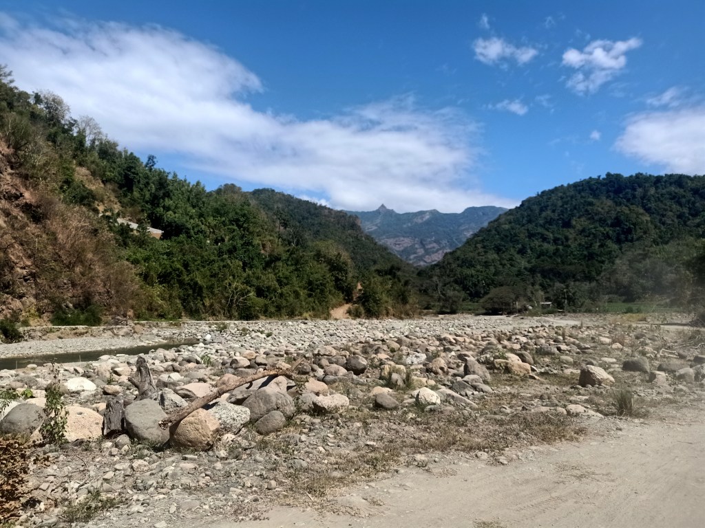
We continued the long ride after completing the needed supplies at the market. There, we passed by the side of the first mountain range, where the road leads to a very narrow dirt path where to our right, which was the side I was sitting, a very high drop off a river can be seen. Afterwards, we were at the middle of a valley with no paved roads. We were in the middle of nowhere; it was just us, the mountains at our side, the boulders strewn on our surroundings, and the river which we followed for the entire duration of the ride. It was reminiscent of the 4×4 ride in Mt. Pinatubo. I was wondering if this was the only way going to the town of GDP. If it was, then it really is a rural area.
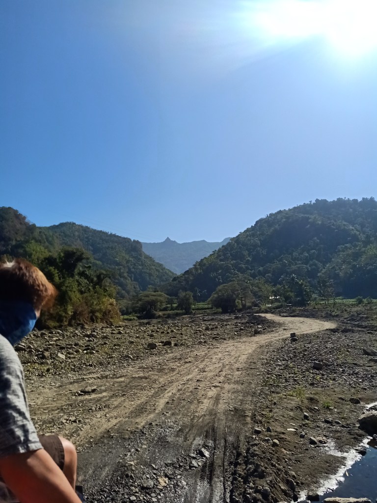
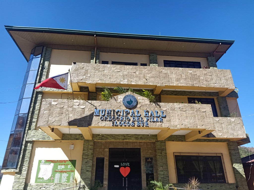
Our butt cheeks were already complaining from the bumpy ride brought by the rocky path we were taking. We also crossed several streams, where to our side, kids were bathing in the murky waters. A few minutes of that bumpy ride, we spotted the pointy Tirad Peak. Luckily, the road-less path turned into an ascending concrete, where a welcome sign that says “Welcome to Gregorio Del Pilar” greeted us. The surrounding was filled with trees by the side, where after a few minutes, we were taking a road at the side of a very large rice field that ends at the slopes of Mt. Tirad. We can already see clearly the mountain by this time. We were going to its left side, in which we entered a very small community inside the wide plantations. At 09:30 in the morning, we reached the municipal hall of Gregorio Del Pilar. There, we registered and paid courtesy at the police station. Then, we navigated the very small town until reaching the end of the road. This was the start of the hike going to Tirad Pass.
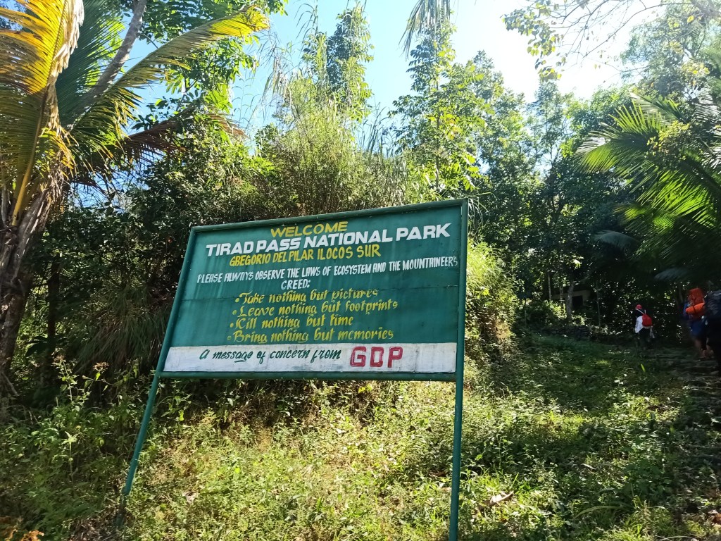
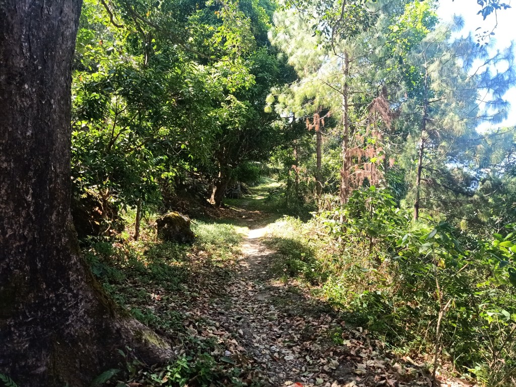
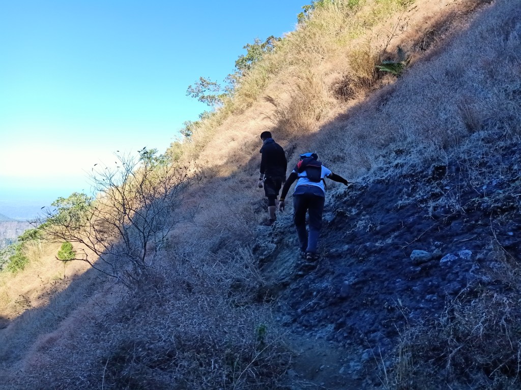
After making some final preparations, we started the hike at exactly 10:18AM. The end of the road leads to an ascending wide foothpath that leads to the entrance of the trail. A welcome signboard greeted us, indicating that we were entering Tirad Pass. Because this was an overnight hike, I brought a full-packed backpack with my tent and other essentials inside the bag. This weight on my back was a new feeling for me as my body was still adjusting since it was accustomed to light packs from doing day hikes. We had a stopover at the first kubo where we had our bathroom breaks and waited for everyone. Afterwards, we resumed the hike.
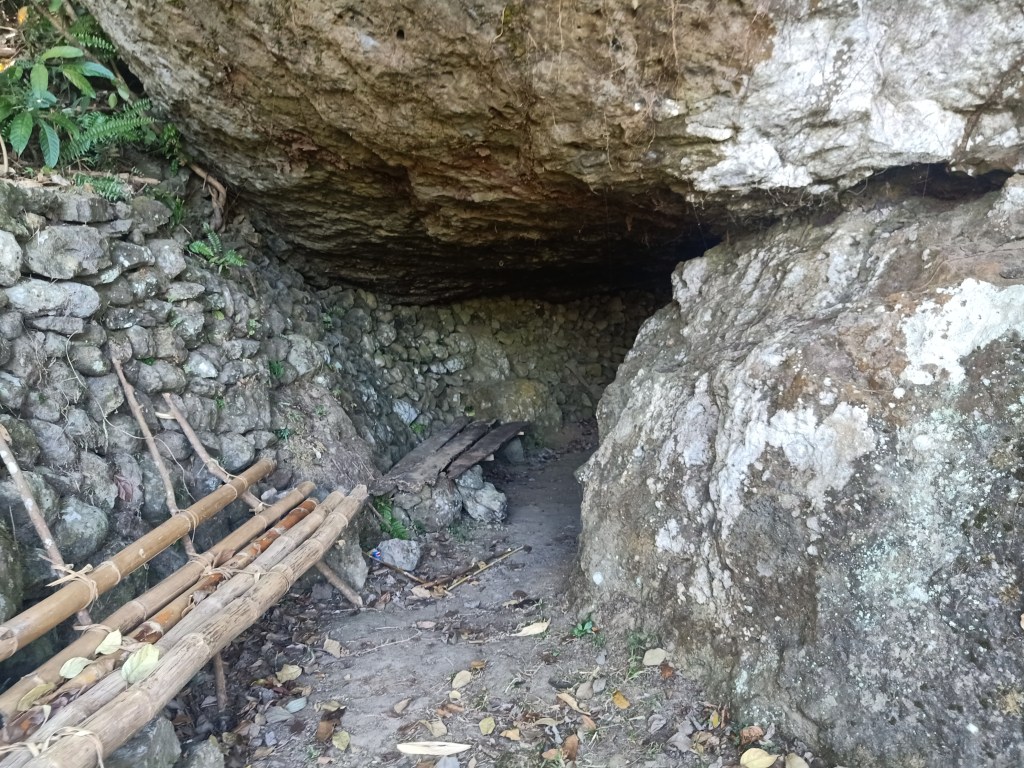
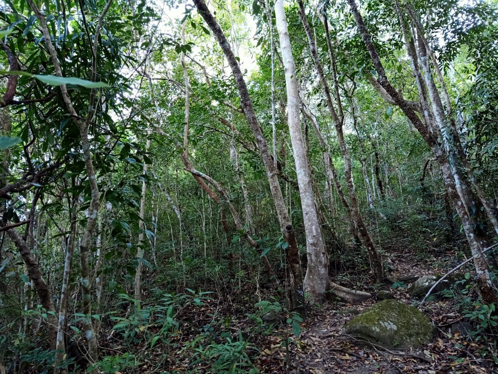
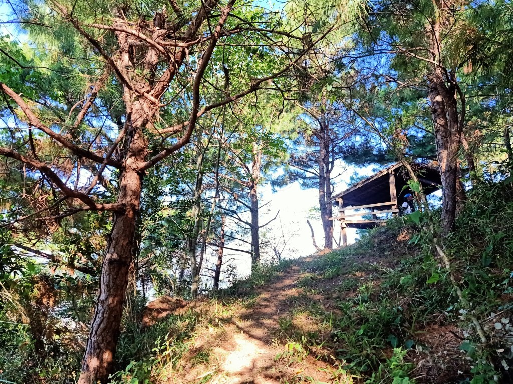
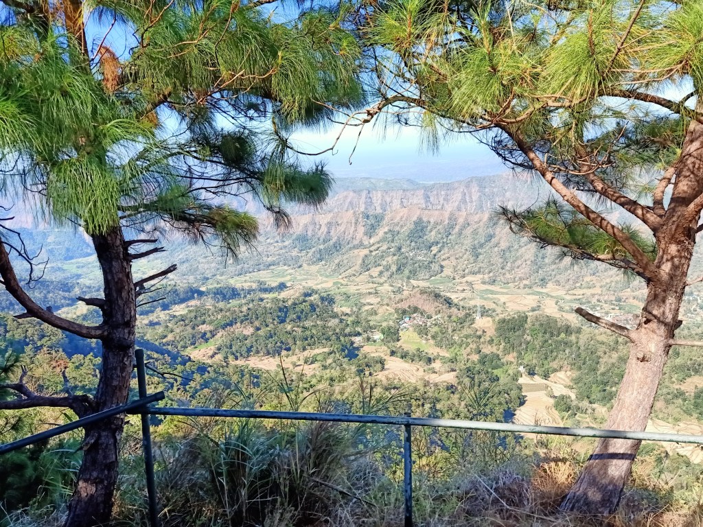
The trail was a constantly ascending wide footpath with a moderate incline inside a forest. This trail would snake the whole area, where we made right and left turns going up. We spotted several kubos as well as boulders encrypted with quotations and reflections about the Battle of Tirad Pass. Most of these writings were in honor of the young general’s heroism. Then, we emerged from the forest towards an exposed ascending trail which leads to a kubo and resting areas by the side of a cliff. There, we saw the mountain range that we passed by going to GDP, as well as the field below it. We rested there for a few minutes and savored the view. Afterwards, we continued our hike. After a few minutes of walking, we passed by a large protruding boulder that creates a very tiny cave below it. This “cave” was complete with benches and resting areas and was said to be where Gregorio Del Pilar rested before ascending Pasong Tirad. We snapped some pictures there and then continued the hike afterwards. Since my body was now getting accustomed to the weight of my backpack, I expedited my pace and told the guide I would go straight to the trail alone. There, I left my companions and went ahead.
Hiking by myself inside this historical trail was anxiety-invoking, and yet, I was awed by the eerie and quiet surrounding. I was treading on a footpath walked on by early Filipinos who suffered during the Spanish colonization, and then waged war against the Americans. I could almost feel their bodies and souls trekking along. As I walked inside the forested trail, I noticed that the plants to my side were making sounds. I was wondering if it was me producing that sound, but apparently, the trail I was treading on was purely soil. I just shrugged the thought of whatever it was and continued the ascent. When I felt that I was far ahead of the group, I sat by a boulder and waited for the guide and the lead group to catch up. When they arrived, the guide told me that he saw a snake, and asked me if I saw one. Apparently, that was the creature that made the gushing sound when I was passing by that area.
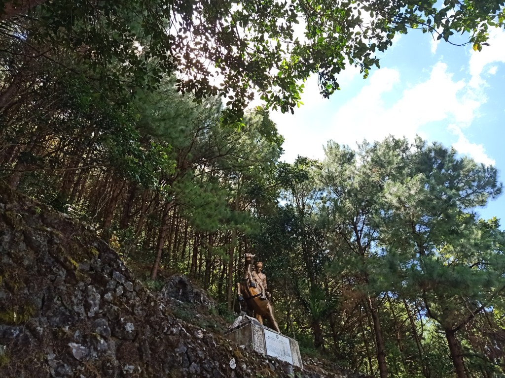
We continued the ascent going to the Tirad Pass Shrine, our campsite and stopover for the day. It was actually only a few minutes from where we were before reaching the shrine. There, the ascending footpath leads to a kubo. The footpath would turn rightwards towards a trail dotted with bamboo tables. These bamboo tables would end towards a junction, where going down straight leads to the Lonely Trail, which we will be taking tomorrow going to Tirad Peak, and a sharp left turn which would lead to the shrine. We reached it by twelve noon, more than an hour and a half after starting the hike. According to my STRAVA record, the trail was 2.88-kilometers long, with an elevation gain of 481 meters. The campsite is recorded at 903 meters above sea level.
The campsite was a cemented footpath where the shrine of Gregorio Del Pilar stands tall above it. At the side of the footpath is a makeshift long kubo perfect for settling down without needing tents. A few meters away, comfort rooms were erected as well as a faucet, where I took a dump and a bath later on that day. Past the comfort room is a trail, which the guide said leads to the town of Quirino.
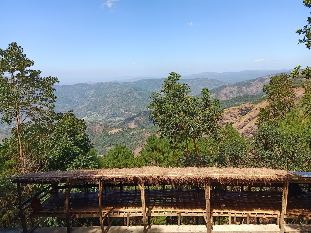
Since there were only four of us in the shrine, I took the moment to snap some pictures. I noticed that at the back of the shrine was a pine forest area, indicating that we were really near the Cordilleras. Afterwards, our companions arrived one-by-one. We accustomed ourselves with the vibe of the place as we rested and prepared lunch. Some of them slept, while some chitchatted as hours passed. I, on the other hand, contemplated by the side of the shrine, as this spot had a sporadic mobile data signal and a very nice view of the town below. As darkness fell over the place, I set up my tent since I did not bring any sleeping bag to fight the cold. After taking our early dinner, I retired to my tent after staring at the night sky filled with countless stars. It was such a magnificent thing to see before sleeping – the light of the universe entering our eyes and processed by our retinas and our brains to see this vast galaxy millions of light years away. I wish we had this more in our urban cities. I slept the cold night away, with some intervals of awakening whenever I needed to change positions and whenever the winds would blow very strong. The cold crept in. I wonder when I will get accustomed to this.
**
At two in the morning of February 23, we woke up and cooked breakfast. We had some coffee and spicy noodles to wake up our senses. This was a much needed meal as we were trembling from the cold night, and as an energy booster for the three hour hike going to the summit. Afterwards, I readied my assault pack and clothing. Past three in the morning, we had our mini-orientation and prayer before starting the hike. We started marching around 3:15 in the morning.
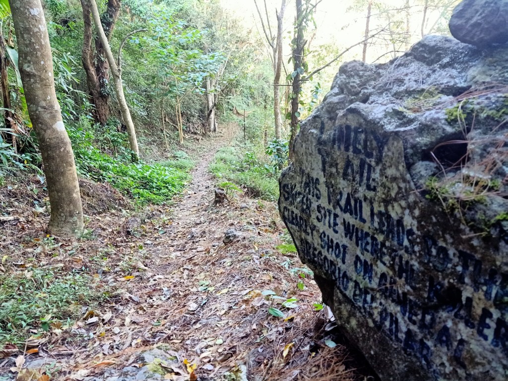
We followed the junction that leads to the Lonely Trail. This trail traverses the mountainside of Mt. Tirad, going south towards Tirad Peak. The initial portions of the hike were a mix of rolling terrain. We passed by the Sniper’s Knoll, the area where Gregorio Del Pilar was shot. We did not stay here as it was still dark, so we marched towards the continuation of the trail. After this portion, it was a constantly descending trail followed by an ascent, which were then followed by a mix of ascending and descending portions. Before ticking the first hour of the hike, we reached an area where our guide warned us that to our right was a dangerous drop. Indeed, when I flashed my headlamp on that side, we spotted a slope filled with trees a few meters afar, and behind it, lights were flickering from a faraway distance. We passed by a downward stream in which precautions should be exercised since the trail is tricky and boulder-filled, and may lead to a dangerous drop at the right side of the trail.
We re-entered the forest once again after the stream. Here, I stepped on loose soil and almost fell at the ravine beside me. Luckily, I was pulled up; I shrugged the feeling off and ignored the wound on my leg and continued the hike. Just a few meters, we encountered the first of the many roped segments of the trail. It was on a steep ascending slope reminiscent of that in Mt. Natib. Afterwards, the rolling trail continues until reaching the halfway point of the hike – a large boulder by the side of the trail complete with rocks where you can sit. We took the time to rest here.
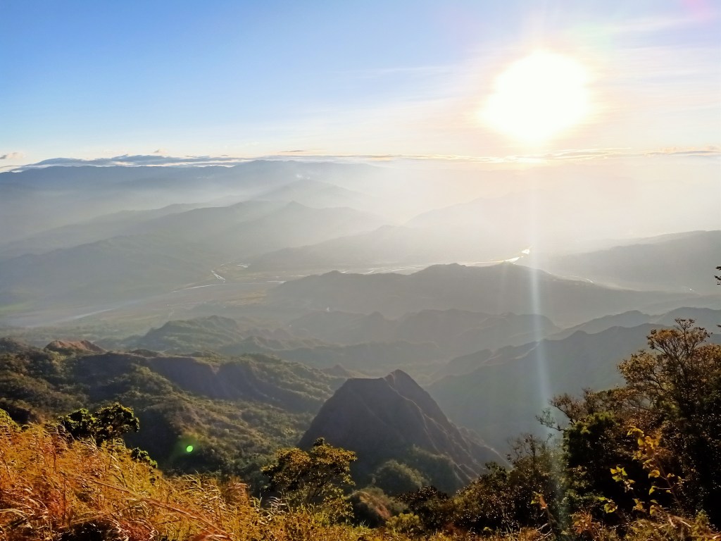
Afterwards, we continued with the ascent. The trail here consists of a constantly ascending trail broken by a few flat portions. We were already panting at this portion as we approached the second hour of the hike. We encountered more roped segments, this time as a descent. Afterwards, I had a glimpse of the peak. It was only a matter of time before reaching its foot. After a few minutes ascending, we made a left turn towards a very steep assault, reminiscent of Mt. Damas. The trail was sharply inclined that our knees were complaining with every step. It was also somewhat slippery. In front of us is a large wall of boulder filled with grass. This makes up the lower reaches of the peak. We negotiated the side of it until we encountered the final roped segment. Daylight was already illuminating the dark place, but since we were in the western portion of the country, we haven’t seen the sun yet at this point. At six in the morning, we reached a narrow ridge at the foot of the monolith. We were now at the summit area.
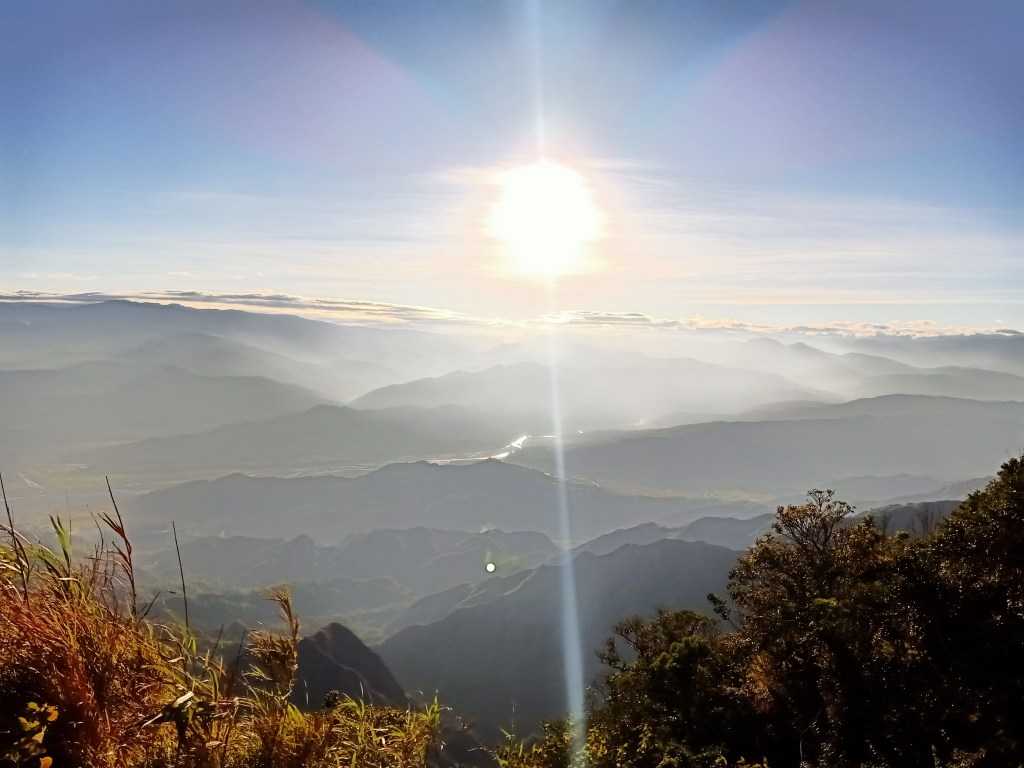
We waited for the sun to rise majestically in the east. Gradually, the bright orange ball ascended the sky, illuminating the layers and layers of mountain ranges of the Cordilleras. To our west, we spotted the mountain range we passed by en route to GDP as well as the West Philippine Sea from afar. To our north is the continuation of Mt. Tirad as well as other mountains behind it. To our south is the monolith dubbed as Tirad Peak, a few meters away from us. Since the wind was blowing strong at that time, the guide did not permit us to climb the monolith. Typically, an adrenaline junkie like me would feel tempted to climb the peak despite the prohibition of our guides. And yes, I was tempted at that time. But there was this contentment of just looking at the monolith at a nearby distance. I knew that some parts of nature aren’t always meant to be conquered, for they sometimes require privacy and recovery from the destructive tendencies of humans. I just sat there, at the very narrow ridge, appreciating this God-given masterpiece around me.

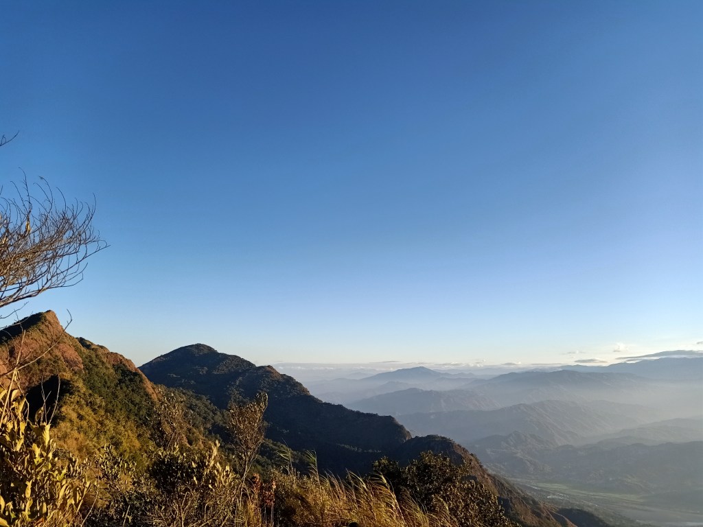
We snapped a lot pictures, taking turns on who poses at the trail going to the monolith, with the big rock as a backdrop. Since I was one of the first to reach the area, I already had my picture taken, so I just sat there and marveled at the view. I can’t help but notice that to our north was a somewhat equally high peak. According to our guides, they recently discovered that this peak was a few meters higher than Tirad Peak. Still unnamed, the guides already trailblazed the route going up there, and it was only a matter of time before they open the trail going up the higher peak. In fact, it might be the highest peak around the area, making it the official summit of Mt. Tirad! The guides also told us that they are planning to close the monolith peak since it’s already damaged from human activities and possibly from ravaging storms. The thought of this new hiking destination fueled my desire to come back to this place when that new summit is opened.
At around 07:15 in the morning, I bid good bye to the monolith. Some of our companions already started the descent a few minutes earlier, while some stayed to snap some more pictures. Going down the steep trail was a lot harder than going up. I had to sit down to carefully negotiate the downward drop. After a few minutes, the steepness stopped and I was once again in the trail going back to the campsite. With the sun now up in the sky, I treaded the well-lit trail on a somewhat fast pace, passing by some of our companions. Then, I was mostly again alone in the trail. Since I needed to advance and not wait for those behind me and catch up with those ahead of me, I continued with the hike without any rests. Luckily, I met two of our companions, Dandy and Harold, resting near the first roped segment. From there, I went with them as I did not like walking alone inside the forest.
We were continuously walking at the trail, with a few stopovers whenever there was a partition of roped segments or streams. We passed by the foot of the other summit we saw earlier, then we spotted the significant areas we passed by earlier – the large boulder marking the halfway point of the hike, more roped segments, the downward streams, as well as the spot where I almost fell earlier. At around nine in the morning, two hours after starting the descent, we reached the Sniper’s Knoll where we found the lead group resting. There, the three of us took our turn to rest and savored the view. “What a beautiful sight to behold before you die,” I told myself, as this place was where the young general fell from being sniped by an American soldier. This area, unlike most parts of the trail, was filled with pine trees, and its footpath filled with dried pine leaves. We sat down and enjoyed the view.
Afterwards, I decided to return to the campsite, which was just a few minutes away from the Sniper’s Knoll. Immediately, I disassembled my tent and organized my backpack. I also synced my STRAVA record – the distance from the summit to the campsite was 4.44 kilometers, meaning that if we take my record yesterday of 2.88 kilometers, the total trail distance of the hike from the jump-off area to the summit and vice versa was around 15 kilometers.
When everyone returned to the campsite, they immediately cooked lunch – corned beef, egg, and rice. We munched on this hearty meal before starting the descent. When everyone was ready, we had some final group shots at the shrine. Past twelve noon, we started the descent. Since the feeling of a heavy pack was new to me, I experienced some mild knee pain as we went down. We reached the road past one in the afternoon. There, our jeep was waiting for us. We immediately put our bags at the topload of the jeep. Unlike yesterday’s ride, everyone was inside the jeepney. Nobody wanted to experience those butt bumps anymore.
Around two, we were at a resort past the valley. Because we were all filled with dust from the bumpy ride, we needed to cleanse ourselves. We took turns in bathing inside the resort. Afterwards, we continued our return to Candon. Upon arriving at the town, we immediately loaded the van with our large bags and our tired bodies. Before returning to Manila, we stopped by a local eatery by the side of the highway and ordered a variety of bagnet dishes – from plain bagnet, to bagnet sisig and bagnet kare-kare. Our tired souls were longing for a whole meal. After eating, I sat by the side of the road, spotting Tirad Peak at a faraway distance with its pointy peak. There, I examined if the peak to its left is actually higher than the monolith peak. During our jeepney ride going to Candon, there were some angles where the left peak would look higher than the pointed peak. But since it was only higher by a few meters, it was hard to say.
At around five in the afternoon, we started our ride going back to Manila. To my right, the sun was setting from the skies, a parallel to the sunrise we encountered earlier that day. It meant that the day was concluding; the events that unfolded throughout the weekend would come to an end. Reflecting on what happened during our hike and the significant stories that happened in those slopes, I stared blankly at the northern view getting enveloped by darkness. I had this mixed feelings of awe, joy, contentment, and sadness. The latter is for our fallen general who died the same age as I am as of this writing. I kept wondering what transpired before the eyes and in the mind of a 23-year old, still young and naïve, and full of idealism. I kept thinking about the whole context of his story – was he a valiant solider ready to sacrifice his life, or a guinea pig used by the ruling elite for their own interests? Was the Igorot villager truly fueled by discrimination and prejudice against fellow Filipinos which led him to betray his own countrymen? One can never fully comprehend the events that came to pass in those places, but with the efforts of our own fellow countymen, places like Tirad Pass remind us of these significant events – mga istoryang may saysay – our ka-saysay-an.
At around eleven in the evening, I reached Malolos. Coming from a historical trip and into my own historical hometown, I was thinking it was now time to make my own history, my own kasaysayan, my own istoryang may saysay.
Itinerary
Day 1:
12:00AM Departure from Greenfield
03:30AM Leeza’s, Sison, Pangasinan, early breakfast
07:00AM Candon, breakfast
07:45AM Start ride going to Gregorio Del Pilar
08:30AM Buy supplies at Salcedo
09:30AM GDP Municipal hall, register
10:30AM Trailhead, start hike
12:00PM Shrine/campsite, set-up camp, socials
08:00PM Lights out
Day 2
02:00AM Wake-up, breakfast
03:00AM Start hike
06:00AM Summit, take pictures
07:15AM Start descent
09:00AM Sniper’s Knoll
09:30AM Back at campsite, prepare and eat lunch
12:00PM Start descent
01:00PM Trailhead, go back to Candon
02:00PM Resort, take bath
04:00PM Candon, celebratory dinner
05:00PM ETD for Manila/Malolos
11:00PM Malolos, home!

2 thoughts on “Tirad Pass and Tirad Peak (1,388+ MASL): Historically Significant Summits III”