Mt. Kalawitan is one of the most revered mountains in the Cordilleras, located in the towns of Sabangan and Bontoc, Mountain Province. Standing at an elevation of 2,714+ MASL, it is possibly the 4th highest mountain in Luzon and unofficially the 10th highest mountain the Philippines. It is known for its scenic pine forest and lengthy mossy forest, and a hefty amount of ascents, taking hikers to the heart of Mountain Province where they can stand in one of the most prominent peaks in the country.

There are two entry points to Mt. Kalawitan. The first is the Sabangan Trail, which starts at the Panorama Viewpoint beside Halsema Highway in the town of Sabangan. This is a shorter but steeper route and was the first trail used a few years ago when climbing Mt. Kalawitan. The second one is found in Brgy. Talubin in Bontoc, Mountain Province. This trail is equally as scenic as the Sabangan Trail but is longer in terms of distance. The Talubin Trail starts at the Golden Farm Resort in Barangay Talubin, and has been the more frequented by hikers in the past few years.

For this hike, we chose the Talubin Trail. I have hiked Mt. Kalawitan via the Talubin Trail before on a day hike (my blog entry for that hike is found in this blog). Back then, we were met with incessant rain and strong gusts of wind all throughout the 15-hour hike. Because of our unfortunate predicament during my first time in Kalawitan, I made sure that I’d go back to this mountain and experience its beauty hopefully with a better weather. I was able to do so in the middle of March, 2024 for an overnight hike. This climb up to Mt. Kalawitan served as my training climb before hiking Mt. Guiting-Guiting for the second time as well. I joined Rabas Outdoors for this hike, where I met some experienced hikers on the trip.
Here are the basic characteristics of the hike:
Jump-off point: Golden Farm Resort, Talubin, Bontoc, Mountain Province
Specs: Major climb, difficulty 7/9
Trail class: 2-3
Days required / Hours to summit: 1-2 days / 8-12 hours
Features: pine forests, mossy forests, 10th highest summit
Here is an account of our hike:
Day 1: Dancing with the rain, fog, and blood leeches
It was already 8 in the morning when we reached Golden Farm Resort located in Barangay Talubin, Bontoc, Mountain Province. It was drizzling when we arrived at the resort, producing flashbacks of the unfortunate predicament I had during my first time in Mt. Kalawitan. Still, I was hopeful that the weather would turn out better in the next few hours. It didn’t.
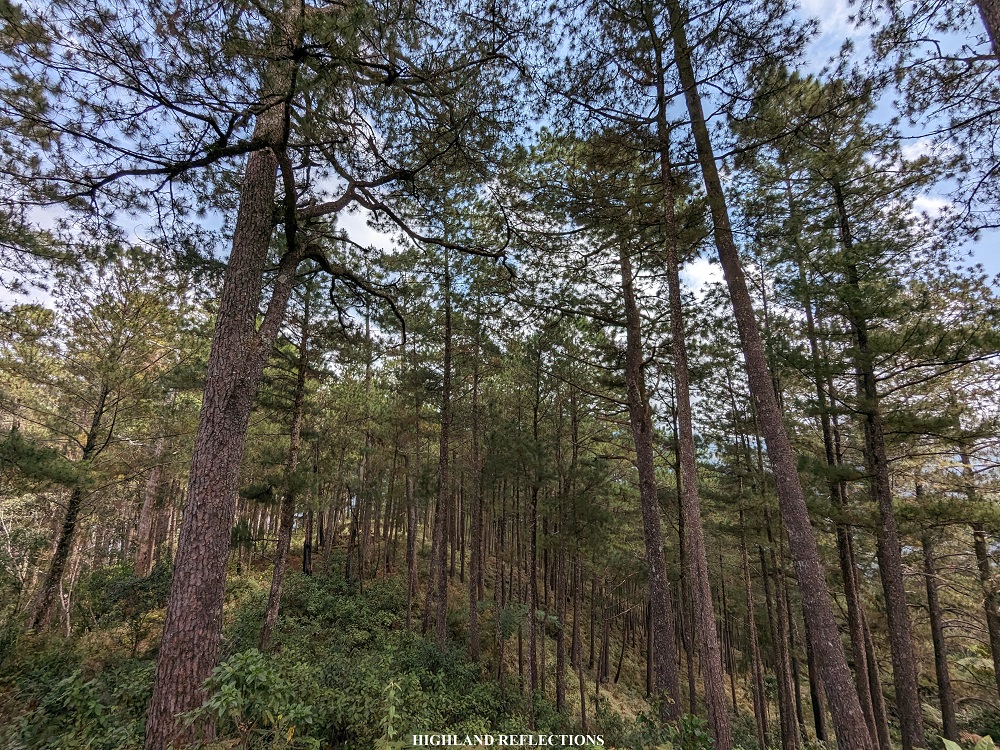
We started the hike around 9:30 in the morning. The trail commences at the back of the dried swimming pool of the resort where a steep ascending staircase leads to a gate. Past the gate is a cemented pathway at the side of an ascending slope used by locals. In the middle of this cemented path is a waiting shed where both hikers and locals rest. A few meters away from the waiting shed is where the cemented path ends, and where the beauty of Mt. Kalawitan starts – an immersion into one of the most dense pine forests in the country!
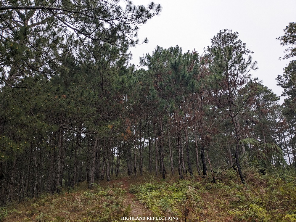

The pine-filled hill at the start of the hike was, thankfully, only covered in thin fog. Unlike my last time there, I had no other view but the eerie sight of pine trees being smothered by thick fog. For this hike, I was still able to see where the Ifugao-Mountain Province highway is carved in the middle of the distant mountain slope to our left – that’s how thin the fog was!
The first few parts of the trail runs on an easy flat section with a few minimal ascents. I was taking my time enjoying the scenery and the much needed workout. Despite the easiness, thick shrubs were bothering us along the way. It seems like this trail hasn’t been frequented by hikers in the last few weeks.
We went on and on, taking in some few altitude gains gradually. The pine forest here in Mt. Kalawitan was such a thing of beauty, and rivals those of in Mt. Purgatory and Mt. Ugo. In fact, if I am gonna make a list of the top five most beautiful pine forests here in the country, Mt. Kalawitan would be included in that list!

The pine forest was a long one. Since this trail is carved on the long mountain range north of Mt. Kalawitan, the trail was expectedly lengthy. What surprised me was that there was now a wide rough road in the middle of the trail, which we encountered almost an hour and a half from the jump-off point. The guides told us that this was used by the loggers in the area. Guides are needed here since the continuation of the trail is at the side of the road. We almost got lost since we followed almost the entirety of the rough road!
Just a few minutes past the rough road was the Rancho, a house-like waiting shed in the middle of the pine forest, which we reached after two hours of continuous walking. This place is a rest stop for hikers, and is also used by loggers as a makeshift shelter. The house-like waiting shed and the big wood plank shelves at the side of the shelter are evidences of logging activities in the area. We decided to have our lunch here.
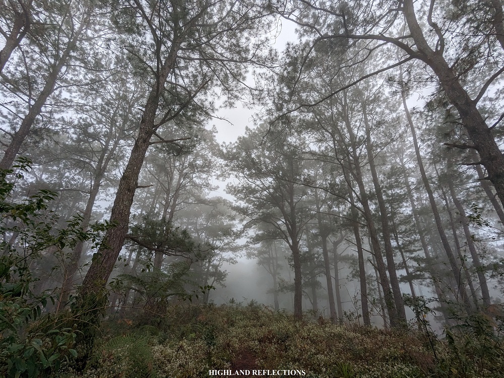
Past the Rancho is another long flat section of dense pine forest. The surroundings here were very scenic! Afterwards, the ascent started to become more pronounced. It took us less than an hour of continuous ascent before reaching Munna Camp, also called as camp 1. Here, rain started to pour, activating my fight-or-flight response knowing that the trail past Munna Camp is the start of the limatik (leech)- infested mossy forest.
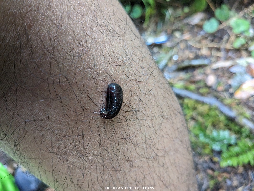
I’m not afraid of mountain leeches, or limatik as we call them. They’re actually very harmless and are more of a psychological nuisance rather than a physical one. My emotional reactions were just brought by the fact that I returned all the way here just to experience rain again. Good thing, though, was that through the years, I have learned how to dance with the rain; especially when I am in a tropical rainforest where it feels like I am being blessed by Mother Nature. It took me years to unlearn my aversion to rain during a hike; I know my unhealthy perception is still there, but at least now, with my wisdom that I have gained through the years, I know how to deal with it effectively when I am in the mountains!
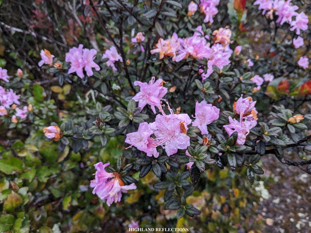
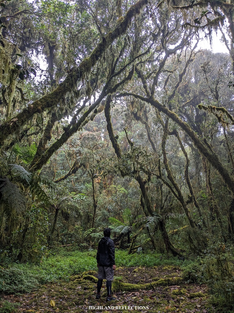
Past Munna Camp, the continuous ascent continued. It wasn’t that steep. It was just an enjoyable incline, gradually taking us further and further into Mt. Kalawitan’s northern ridge. We entered a short section of a mossy forest before exiting onto the last few stretches of pine forest. Past the short pine forest section, we entered the expansive mossy forest trail of Kalawitan. The inclines dissipated for a bit, as this part is now flatter than usual. However, the aggressive limatiks started to make their presence felt. I had one on my left leg, which I permitted to suck my blood for the rest of the day. The other limatiks weren’t as lucky as I was actively removing them from time to time.
I waited for my companions at the water source inside the mossy forest, which, sadly, during our hike, was all dry. After a few minutes of rest, we continued hiking. There were now again some pronounced inclines that we had to take inside the mossy forest. Sometimes, the trail was also narrow and had a shallow ravine on the left. It was drizzling all throughout the entire hike up the mossy forest.
At around 3 in the afternoon, I reached the emergency camp (or E-camp) in the middle of the mossy forest. Our local guides decided to have our camp here since the second campsite was still far away and a lot of our companions would arrive there at night if we pushed through.
I immediately set up my tent as rain was still continuously pouring. I had some limatiks attached to me every now and then. Upon setting up my tent, I tried to cleanse all the blood flow from my limatik bites. I discovered that I had another bite on my right foot, and that there were smaller leeches attached to my socks! I spent the entire hour cleaning myself and attending to my limatik bites. It was an irritating predicament that I was in.
We had our dinner past six in the evening. I joined in some social sessions and drank a few shots of gin before going to sleep. That night, it was cold.
Day 2: Summit assault and a sunny descent
I woke up around three in the afternoon. Since it was still raining, I was contemplating if I was gonna do the summit assault or just continue resting at the campsite since I already summitted Mt. Kalawitan in the past. I wasn’t able to decide inside my tent, so I went out and drank some hot coffee to ease my brain. And then it hit me… I wanted to reach the peak still. I’ve pushed myself all the way here because that was the plan all along.

We started the summit assault past four in the morning. It was still dark and foggy when we started. We could see some drizzle particles in the atmosphere. The trail was also a long one. Just like the previous day, the ascent inside the mossy forest were only mild and gradual. Still, it was quite lengthy. After an hour, we passed by Juuno’s Playground – a swampy area in the middle of the forest filled with the thickest moss I have seen. After that was another stretch of long gradual ascent before reaching Camp 2, also called Mateo’s Garden, which was a small open area that could fit only a group of hikers.
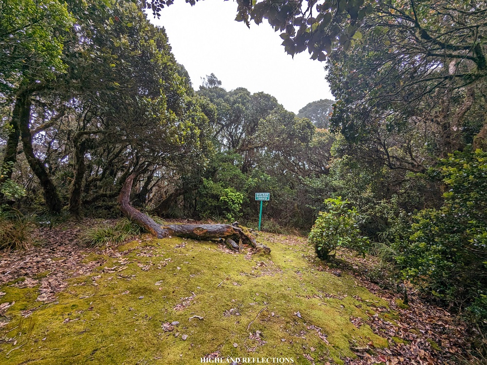
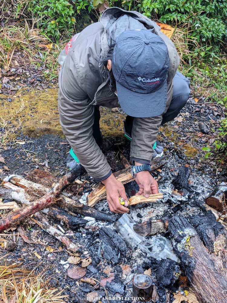
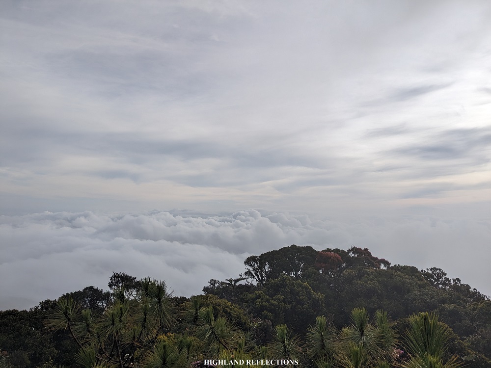
Past Mateo’s Garden was another round of long stretch of mossy forest trail. Here, sunlight caught up to us as we were nearing the summit. After more than thirty minutes past Mateo’s Garden, we arrived at the summit of Mt. Kalawitan. It was seven in the morning. The two guides, one of the joiners, and I were the first to reach it for that day. Thick fog enveloped the entire shrub-covered summit. I snapped some pictures at the dilapidated summit signage and rested at the rear part of the summit where the guides set up a campfire to warm our bodies.

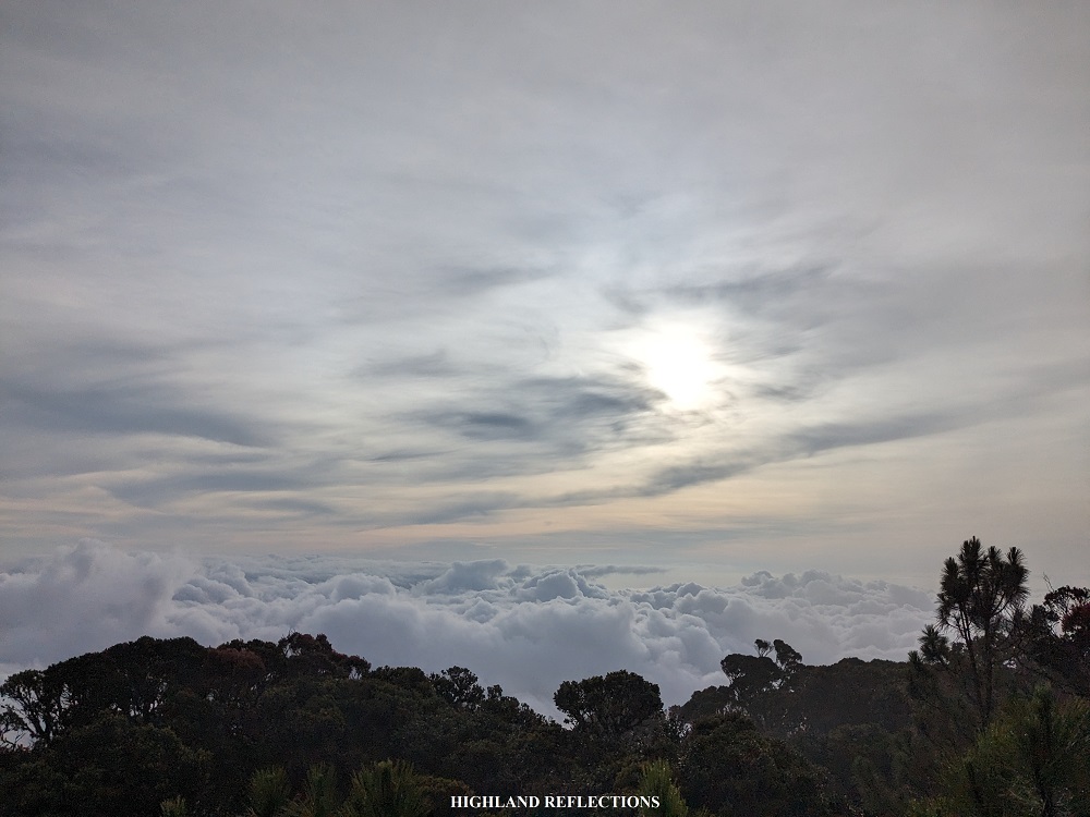
After thirty minutes of chatting with the guides and exploring the area, the skies cleared up for a bit and gave me a limited-time showing of a sea of clouds in front of the summit! The cloudscape was made up of chaotic puffs of cotton-like clouds. The sun was above the clouds, towering over the majestic beauty I was seeing in front of me. I thanked the heavens for blessing me with such a view in my second time on this mountain!
The clearing closed after some long minutes of teasing us. I decided to go down to our campsite to have my breakfast. Before reaching the campsite, we snapped some pictures in Juuno’s playground. I reached the campsite after two hours. I immediately munched on our breakfast and broke camp afterwards.
We started the descent (without a guide) past 10 in the morning. Leading and guiding the way, I briskly walked the entire section of mossy forest so as to avoid getting more limatiks on the way down. In just under an hour, we reached Camp 1. There, I was able to have a long rest to check my body parts for leech bites. Good thing was that I found none! As my companions were just tailing behind, we were able to have a photo-taking session in Camp 1. The clear sky and sunlight enabled us to have a well-lit backdrop of the pine forest surrounding us!
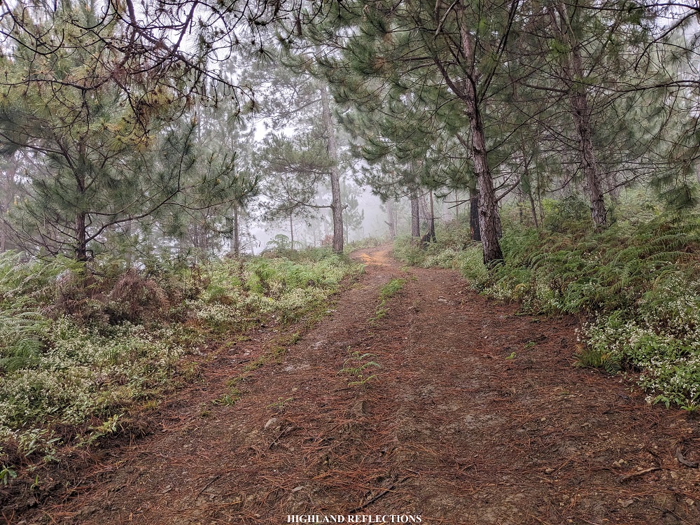
We continued with the hike after a few minutes of rest. The constant descent past Camp 1 ran on some dense pine forest. Along the trail, I could spot Bayo Rice Terraces to my right. We were blessed with clear views of the surrounding mountain slope where the Ifugao-Mountain Province highway is carved.


I enjoyed the brisk walk inside the pine forest. The clear sky complemented well with the charm of the dense pine forest. Upon reaching the Rancho, I rested for a bit before continuing the last few portions of the descent. On the way down, I was able spot some beautiful sceneries along the trail. With minimal stops, I reached the resort past one in the afternoon. Mt. Kalawitan: completed for the second time!
I immediately took my bath and washed all the accumulated dirt on my skin. At four in the afternoon, the team was complete. We went home with an accomplished feeling in our hearts.
Returning to Mt. Kalawitan as part of my training climb for Mt. Guiting-Guiting was worth it. Although it was drizzling almost all throughout the hike, I felt lucky to have witnessed a cloudscape view at the summit. Added to this was the breathtaking pine forest basking in sunlight as we went down the mountain. I guess this was just Kalawitan’s way of welcoming those who dare enter its premises. It is its way of asking climbers of the classic philosophical question: To climb or not to climb?
Of course, we know that the only correct answer is to climb!
Kalawitan: from the Kankanaey word “kalawit”, meaning, “to climb”
Itinerary
Day 1
07:00AM Breakfast at Polis
08:30AM Arrival at Golden Farm Resort
09:30AM Start hike at Golden Farm Resort
11:30AM Rancho, lunch
12:00PM Camp 1
01:00PM Water source
03:00PM E-camp, set-up camp
06:00PM Dinner
08:00PM Lights out
Day 2
04:00AM Start of summit assault
07:00AM Summit, take pictures
08:00AM Start descent
09:30AM Back in e-camp, breakfast
10:00AM Break-up, start descent
01:00PM Back in Golden Farm Resort, wash-up
05:00PM ETD Manila

One thought on “Mt. Kalawitan (2,714+ MASL) Overnight | via Talubin (Bontoc) Trail”