One of my bucket lists is to hike all of the trails in Mt. Pulag. So when my friends invited me to do a day hike in one of the sacred mountain’s major trails, I immediately grabbed the opportunity. For this hike, I got the chance to take the seldom-taken Tawangan Trail of Mt. Pulag. The trail is infamous for its long mossy forest and presence of highly aggressive and larger-than-usual blood sucking limatik, hence, its notorious nickname for being the “Bloody Trail” of Mt. Pulag. The immersion in the northern portion of Pulag was one for the books, as we were graced by the northern elements of this mythical mountain.
MT. PULAG via TAWANGAN TRAIL
Major jump-off point: Tawangan, Kabayan, Benguet
Elevation: 2,926+ MASL (9,600 ft)
Days required / Hours to summit: 1-2 days, 8-10 hours
Specs: Major climb, Difficulty 7/9
Trail class: 1-3
Trail distance: 21.80 kilometers (Tawangan to Ambangeg)
Source: transitpinas.com & pinoymountaineer.com
I altered some of the information presented here based on my own observations.
This was actually my third time climbing Luzon’s highest summit. Both my first two climbs were in Ambangeg, so I was pretty excited to cross out one of the major trails of Mt. Pulag. I signed up for this event when my friends Rex, Fara, and Cristine invited me in for a day hike. We were joined by Mon, one of their common friends, and we were led by elite trail runner Nar. Six brave souls in total.
We started our day hike at 2:40 in the morning somewhere in Tawangan in Kabayan, Benguet. The trail starts on a mountainside filled with pine trees (this mountain, according to blogs, is Mt. Ludok), which quickly transformed into a mossy rainforest as we covered more distance and elevation. When sunlight caught up, we had a glimpse of the neighboring mountains on the eastern direction, giving us hope for the long day ahead of us.

The vegetation of the forest was thick, and was probably the most verdant forest I have ever encountered. As the forest was filled with wilder elements, we were stopping every now and then to remove limatiks crawling on our clothes. The leeches here were much, much larger than the average limatik, and were so aggressive that even if I was actively removing them, I had two limatik bites garnered for the entire hike. I actually counted myself lucky, as my friend, Cristine, had more than a hundred limatiks attached to her, and had a total of more or less 20 bites for the entire hike!
Along the trail are gullies and streams that seem to block some parts of the trail. As the clock ticked before seven in the morning, we rested at a downward stream and munched on our breakfast. At this point, my legs were already aching as this was my fourth consecutive hike during that month. I didn’t know what got in my head when they invited me for this hike, knowing the difficulty that lies in this wild, wild trail. No regrets though!


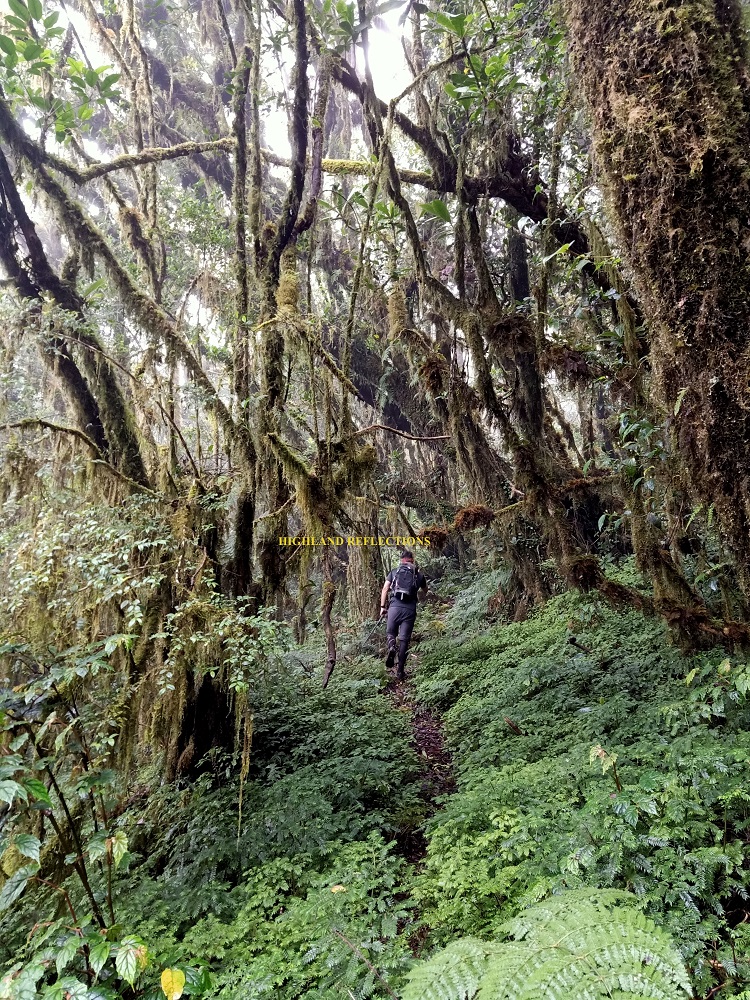

The forest’s moss got thicker and thicker as we gained more elevation. Although we were slowed down by the persevering limatiks, and my cumulative tiredness seeping in, it did not stop us from enjoying the impressive forest surrounding us. The chaotic sprouting of branches formed this otherworldly environment, colored in verdant moss, and blessed by the wild elements.
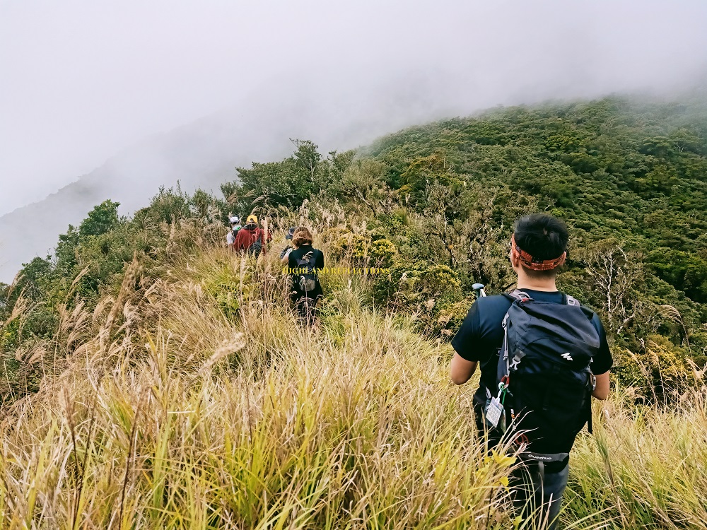
Six hours into the hike, we encountered several fallen logs and phantom pits blocking an open ridge trail. This was probably the most dangerous part of the hike. We were stepping on assemblages of branches of fallen trees that could snap anytime and make us fall on the ridge to our left. We carefully treaded and crawled here. After an hour, this led to an open grassy ridge that resembles a knife edge, dubbed by locals as Mt. Pupulag. We stayed here for some minutes, enjoying the view of the surrounding nearby forested mountains.
We then re-entered the mossy forest of the mountain on the other side of the ridge. The ascent continues, and was probably the last (long) stretch before reaching the grassland area of Pulag.
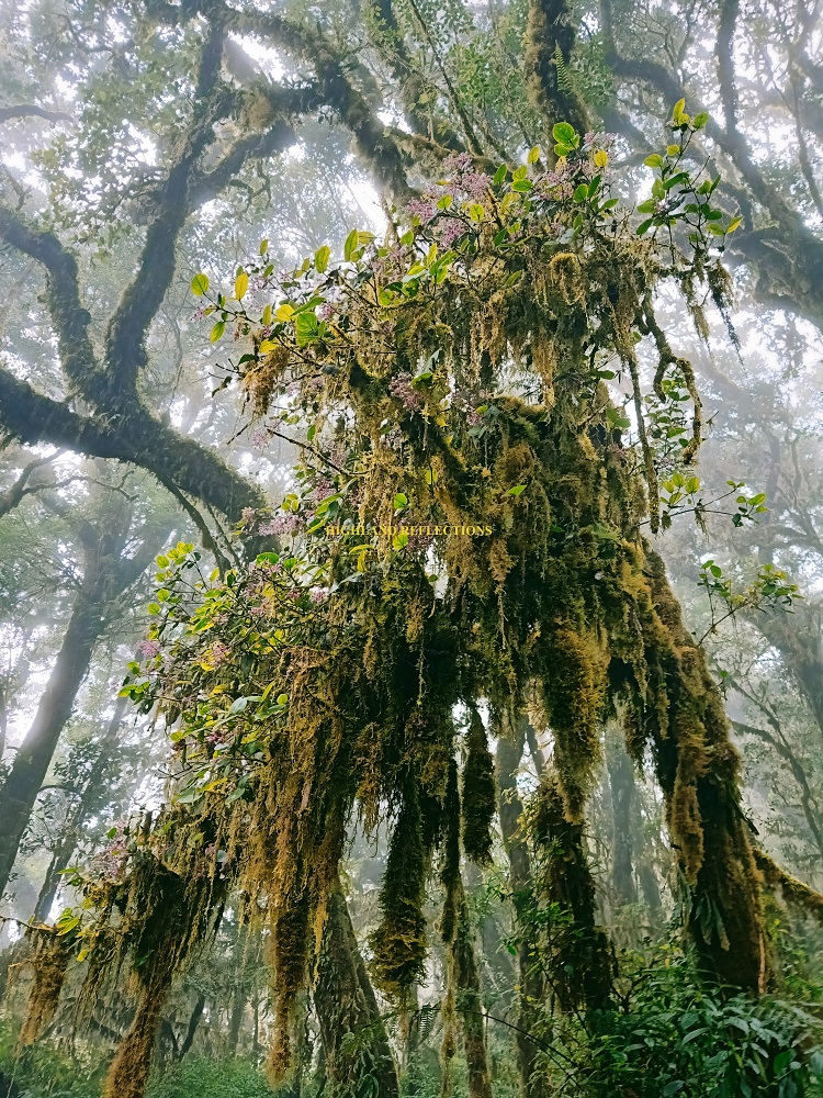
Along the last stretch of the mossy forest, we encountered the iconic tree with lobe-shape branches dressed in moss, forming an otherworldly shape. This is where hikers typically stop to snap photos because of the tree’s weird but alluring appearance. Beside this tree is another tree with spiked-shape branches, reminding us of the chaotic structures of the Netflix series Stranger Things’ visuals of the Upside Down.
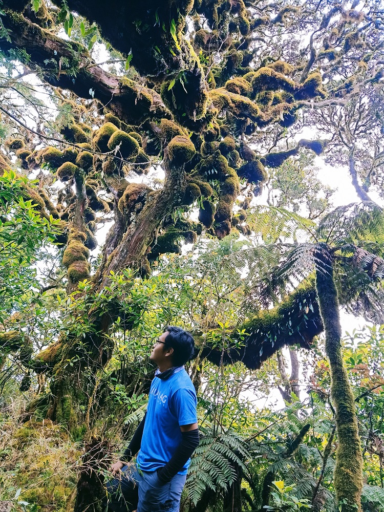
Vecna may appear anytime and snap our already weakening limbs.
Anyhow, we continued the last stretch of hike up the mossy forest. As the clock ticked before one in the afternoon, almost 9 hours after starting the hike, we finally exited towards the open grassland of Mt. Pulag. Our faces unconsciously formed a smile as we all probably shared a feeling of relief for finally exiting the fear-inducing trail of Tawangan. Limatik no more! Who knew that touching grass (heh) would make us the happiest people on earth.
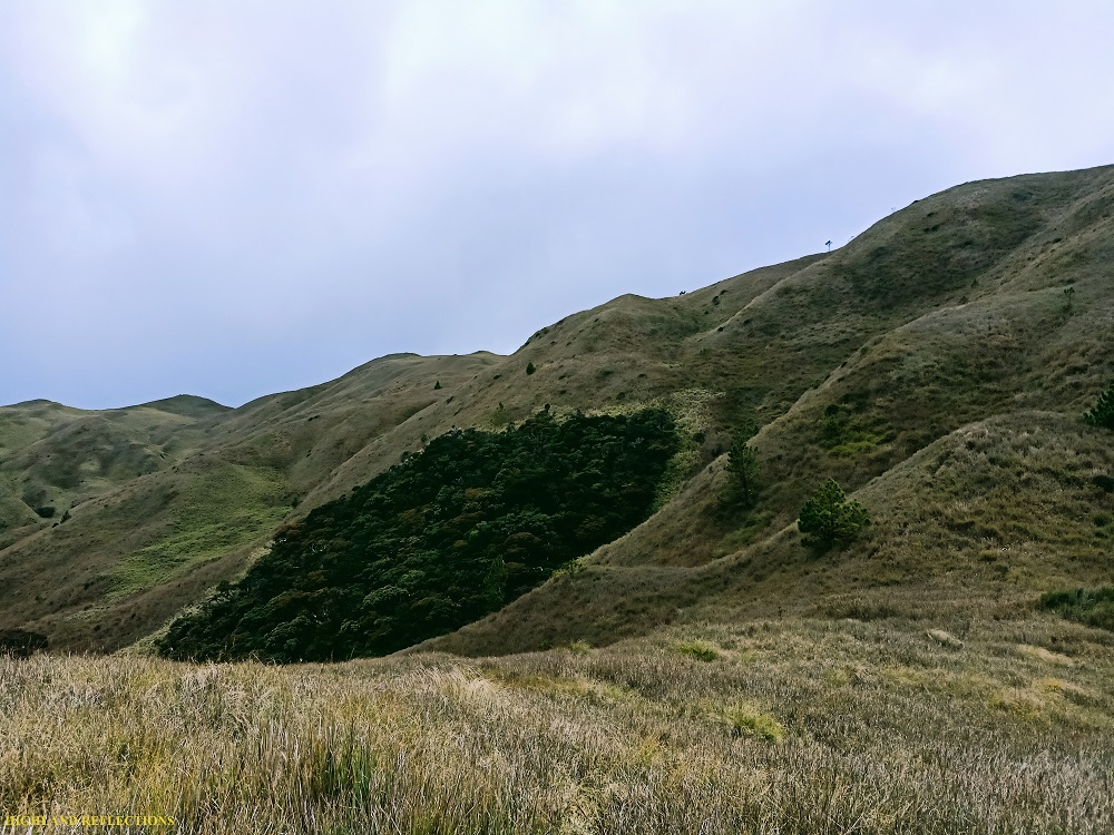
We ascended the first grassy hill that we encountered upon exiting the mossy forest, and followed an open path that merges with the Ambangeg Trail somewhere in the upper parts of the grassy knolls of the summit area.
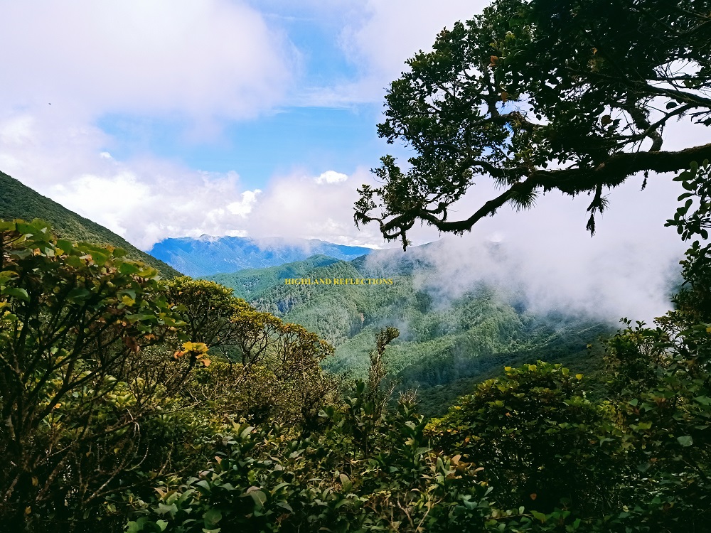
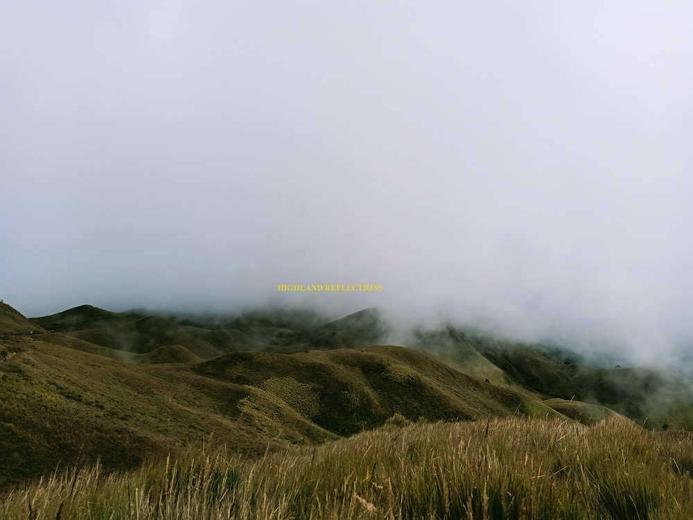
At around 1:30, I was the last to reach Pulag’s summit. There, we rested and munched on some snacks. As the visitors for that day already descended, we all had the summit to ourselves. The afternoon sky brought down the clouds, blocking the view of the surrounding mountains, but maintaining a vista of the surrounding grassy knolls of the summit area. There was also a small opening that let us view Mt. Timbak on the western side.
We concluded the epic day hike with a hike down the 8-kilometer Ambangeg Trail. It was familiar territory from this point, and although we were hastening our pace to reach Sitio Babadak early, it felt relaxing to (power) walk the established path of Ambangeg. The skies at this side of Pulag seemed calmer than that of the Tawangan side. We had an awesome view of the neighboring Mt. Salinsingan and Mt. Purgatory in the southern direction. Before 6pm, we reached Sitio Babadak and rested at one of the homestays there. We waited for our van ride to fetch us and drive us home.
What an epic climb.
Tawangan Trail, by far, has the wildest and the most beautiful mossy forest I have witnessed in the entire country. I hope its wilderness never changes so that those longing for an epic adventure would be given the opportunity to experience Tawangan’s beautiful chaos.
Hoping that I could try the Akiki and Ambaguio trail in the future!
Itinerary (directly lifted from Transit Pinas’ blog)
02:30 Arrival at Brgy. Tawangan, Kabayan, Benguet
02:40 Start trek (1,474 MASL)
05:30 Rest area (1.970 MASL)
06:55 Creek/Water source, breakfast (2,020 MASL)
09:45 Mt. Pupulag Ridge (2,350 MAS)
12:45 KM 12.40 Grassland (2,678 MASL)
1330 Summit Mt. Pulag (2,922 MASL)
1500 Start descend via Ambangeg Trail
1700 KM 19.40, Camp 1 (2,494 MASL)
1730 KM 21.80, Ambangeg Ranger Station, rest, tidy-up
2200 Depart for Manila
