Last 20th of June, I joined Akyat Tanaw Mountaineers together with my other companions from the first Magsaysay attempt-turned-into-Tinucan Circuit hike in what occurred as my wildest hike this year! We finally had the chance to climb the long-awaited Magsaysay Mountains. For this hike, Mac Wilson of Mudman Trekker, the caretaker and guide of the Magsaysay Mountains, invited us to take a newly-established trail coming from Barangay Tanauan in Real, Quezon, starting at the side of the Famy-Real-Infanta Highway, traversing the mountains of Real northwards via Kagsa River, and ending at the slopes of the Magsaysay Mountains. One can climb the Magsaysay Mountains afterwards.
However, for this hike, we were not able to summit the peaks of the Magsaysay Mountains due to fatigue after the extended river trekking in the earlier parts of the hike. Hence, this blog only narrates our hike starting from Tanauan up to our exit point in Marilaque Highway. My entry for the Magsaysay Penta Traverse that occurred a week after can be found in this blog.
As described earlier, this hike has been my wildest for this year. We crossed Kagsa River 26 times in a span of six hours, and because we were so exhausted, it took us another six hours coming from the end of Kagsa River to the foot of the Magsaysay Mountains in what they call an “ambush area.” With this difficulty, here are my observations for the hike:
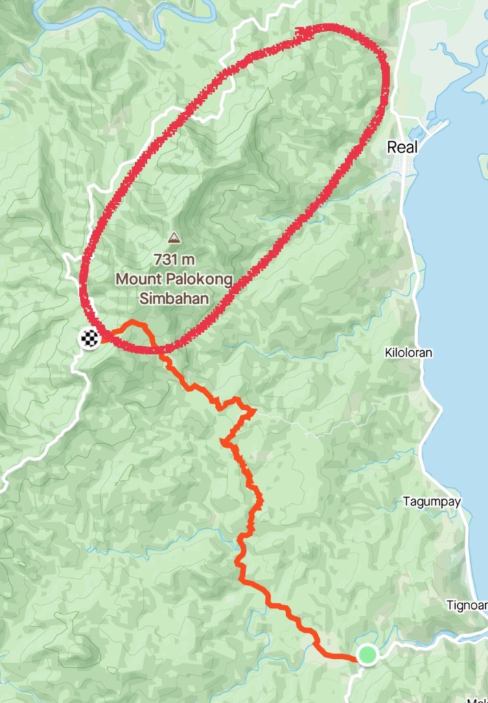
Jump-off point: Famy-Real-Infanta Road, Brgy. Tanauan, Real, Quezon
Exit point: Marilaque Highway (near Querocep Bridge), Infanta, Quezon
Difficulty: major climb, 7 to 8/9
Trail class: 1-4
Features: river crossing, uncharted waterfalls, virgin rainforests, view of Lamon Bay and Pacific Ocean
Note: It is best to coordinate with the locals before climbing the Magsaysay Mountains. Checkpoints both in Marilaque Highway and in the Famy-Real-Infanta Road are stringent when entering Infanta or Real since both towns are restricted areas. You may contact Mac Wilson of Mudman Trekker on his Facebook account.
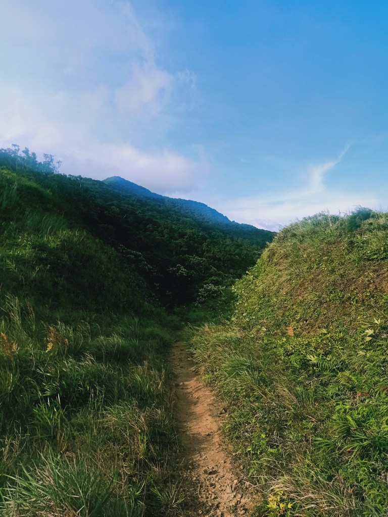
We started the hike at exactly 05:19AM. Coming from the Famy-Real-Infanta Road, we took a continuously descending trail that ends on a wide river bank. At the early parts of the hike, we already had a faint view of the Magsaysay Mountains in the horizon, foreshadowing the long hike ahead of us for that day. After crossing the river several times, we entered an ascending slope filled with ferns, similar with the lower slopes of Mt. Napulauan. Afterwards, we descended towards the river once again.
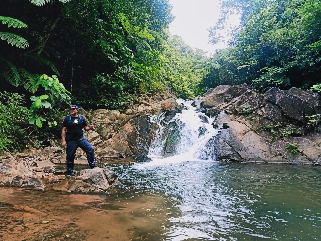
I’ve had my fair share of experiences of river trekking in the past—all of which, I hated. There was the short, but technical river trekking in Mt. Damas. Then, the trail-less exploration in DRT’s Bulacan Peak back in January. If I am to compare those river trekking from what we did for this hike, the previous ones do not even come close. I didn’t just hate this one, I was exasperated by it. Compared to the former two, the one in Magsaysay was longer and wilder. It had a combination of the Damas and BulPeak river crossing characteristics where we needed not just to leap on boulders, but we had to wade the waters of the river and climb some steep, slippery boulders by the side. In some parts of the river, the water aggressively gushes. Most of these parts of the trail were dangerous and certainly not for those wanting to just walk on mountain trails. It was hard-on, hardcore hike not for the faint-hearted.
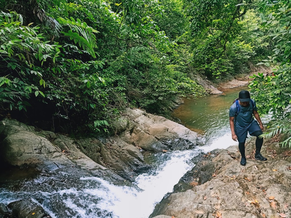
What compensates for the tiredness were the unspoiled, unnamed, uncharted waterfalls that we encountered during the hike. We were able to come across almost five waterfalls, with gushes that were strong and basins that were unmeasurably deep. Although I did not bother to dip into the water due to fatigue, it was mentally relaxing, knowing that we were deep into the wilderness of the Sierra Madre Mountain Range.
We exited the river trail past 11 in the morning. Here, we took an ascent once again on a fern-filled slope with short trees scattered randomly. Starting from here, the hike becomes a long walk and a gradual ascent to the ambush area. Due to extreme tiredness, we were walking like zombies! We then entered a forested slope filled with dipterocarp trees, highly similar to any Southern Tagalog mountain. Around 11:30, we had our lunch in the middle of the forest and slept until 12:30 where we continued the hike.

At around three in the afternoon, after continuous walking with no sight of the ambush area, some of my companions and I decided to just take a chill walk and not bother to summit the five peaks of the Magsaysay Mountains anymore. Only two of our companions decided to push forward with the ascent to the five peaks while the rest of us decided to just take the exit point in the ambush area. The two that would push through expedited their pace and left us behind. From here, we slowed down and enjoyed the scenery of the forest.
Around four in the afternoon, we reached the long-awaited ambush area. From here, it would take another 4-6 hours if we would climb the five Magsaysay peaks.

The ambush area is called as such because its trail is in the middle of two grassy slopes where you can be “ambushed” if there’s a gunfight. The trail leading to the five peaks was on one of the slopes.
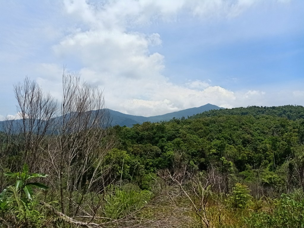
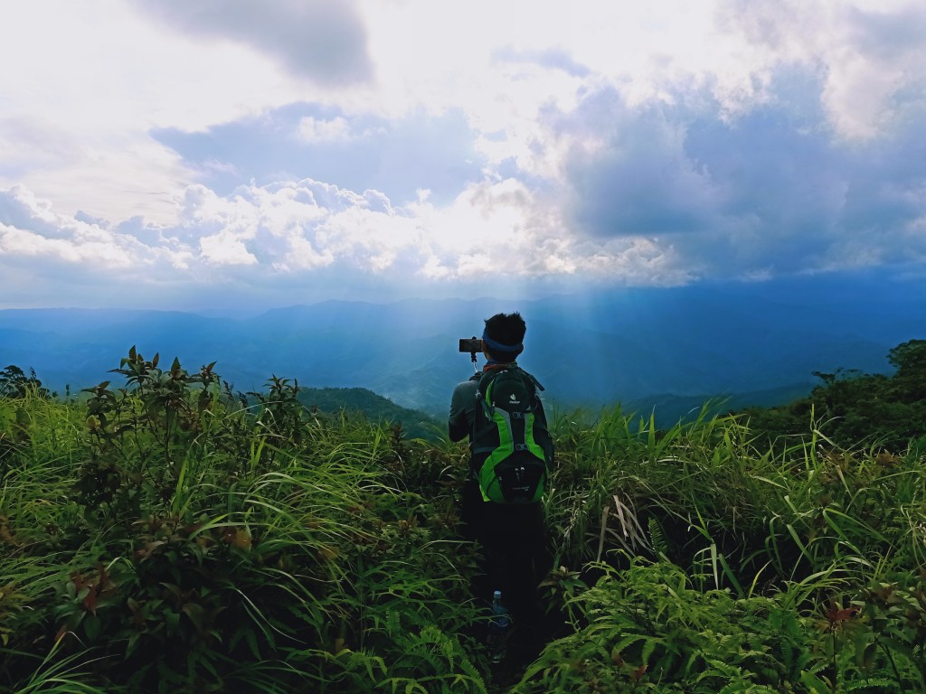
We took a long rest around the ambush area. Some of our companions took the chance to sleep while my companions and I snapped some photos of the picturesque spots of the area. The best spot shows the gigantic mountains of General Nakar in Quezon. The highest mountain, according to our guide, is Mt. Kamamasam.

We then decided to push through with the descent. From the ambush area, it only took us thirty minutes to reach Marilaque Highway. The locals call the area as “Querocep” and is surrounded by the Magsaysay Mountains to the right and the mountains of General Nakar to the left. As we walked the highway going to our guide’s in-laws house, I spotted some pine trees at the side of the road, making me reminisce our Cordillera pursuits pre-pandemic. Since there was no vehicle available, it took us almost two hours negotiating the highway until reaching the guide’s in-laws house at the side of the road.
All of us took a hearty meal of tinola after that long, extreme, hardcore hike. Afterwards, we journeyed back home, reaching Metro Manila past twelve midnight.
A week after, I returned to summit the Magsaysay Mountains.
Itinerary:
Day 0
11:00PM ETD Greenfield
Day 1
01:00AM Early breakfast at Siniloan, Laguna
02:00AM Guide’s house in Real, rest
05:30AM Start hike and river trekking
11:00AM End of river trekking, start hike to ambush area
11:30AM Lunch, rest
12:30PM Resume hike
04:00PM Ambush area, rest
05:00PM Exit point at Querocep
07:00PM Guide’s house in Infanta
11:59PM Back in Metro Manila

One thought on “Magsaysay Traverse New Route (Tanauan to Magsaysay via Kagsa River)”