Much like any other mountaineer, I, too, have been curious as to how a mountain with low elevation such as Mt. Damas (685+ MASL) can be rated as difficulty 6/9. Situated in northwestern part of Tarlac, Mt. Damas was only opened earlier this decade by mountaineers exploring the Zambales-Tarlac mountain range. It borders the town of Camiling, San Clemente, and Mayantoc. Famous for its ‘cardiac’ trails, river crossings, rappelling, and rock scrambling, Mt. Damas offers more than the usual mountain hike, despite its low elevation. During the end of 2019, I finally had the opportunity to climb this ferocious mountain.
For this hike, I joined a different group since my constant group was not organizing a year-end climb. “What better way to end the year with a major climb,” I told myself. For the two years that I have been completing major climbs, the mountains of Central Luzon and Cordillera have had a special place in my heart. I promised to myself that I would be completing and familiarizing myself with the identities and idiosyncrasies of these mountains close to my home. Mt. Damas was included in that list, and I was about to acquaint myself with this small, but terrible mountain.
I met the group at McDo Kia Theatre in Cubao around ten in the evening of December 27. Leaving the Metro at eleven, we reached Barangay Papaac in Camiling, Tarlac past 2:30 in the morning. Since it was still too early to start the hike, we passed the time to nap and have breakfast. We even chitchatted with the guides about the different mountains surrounding the area – from Mt. Semilya (I know, right?), which was just beside Mt. Damas, the 50 km traverse to Mt. Tapulao starting from the town of Mayantoc, the San Jose Circuit in the town of San Jose, to a newly explored-mountain with a mossy forest in the same town – the possibilities of mountain explorations in this region is still abundant. By four in the morning, we registered and readied ourselves, and at exactly five in the morning, we started the hike going to Mt. Damas.
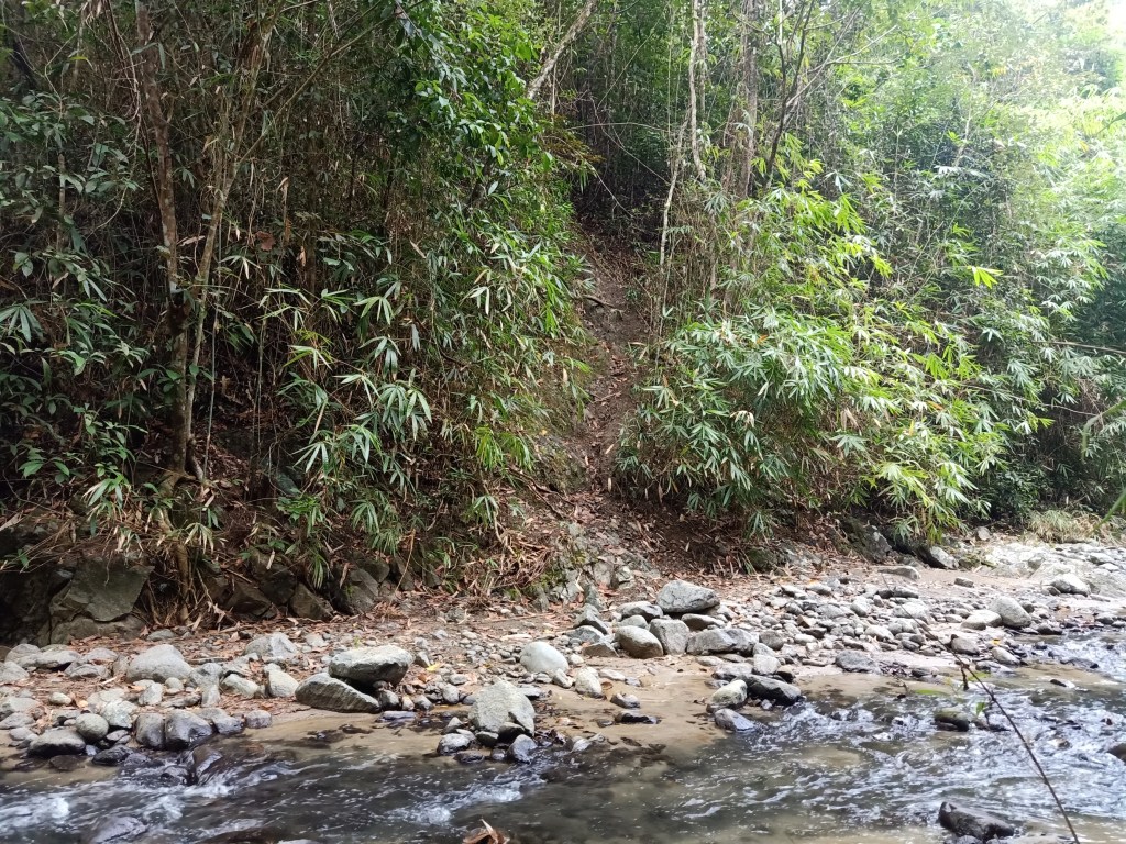
The hike starts at the road outside of the registration site. This paved road would eventually turn into a dirt road just after a few minutes of starting the hike. The trail is characterized by a gradually ascending pathway that extends for long kilometers.It was kind of impressive how there were only a few houses for this part of the trail. The initial parts of other mountains are usually residential areas where houses would really dot the place. For Mt. Damas, I only saw maybe two or three houses for the whole area.
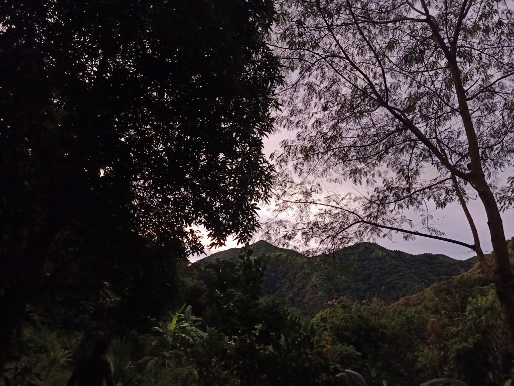
For one whole hour, we negotiated this flat to gradually ascending trail, which would sometimes roll into descending portions. Even in the early hours of the morning and the dark sky, I can already see the abundance of trees in my surroundings, indicating the preservation of the area despite human activity. I can also hear waters gushing by my side. Then, the trail transforms into a completely ascending trail, which was still not as steep as compared to the one we would ascend later that day. Afterwards, we descended towards a kubo, where we had ample rest before negotiating the river trail. Mt. Damas can already be spotted at this point. It seemed near, and it seemed low. I wonder what difficult trail awaits us. I was about to experience the wrath of a 6/9 difficulty mountain.
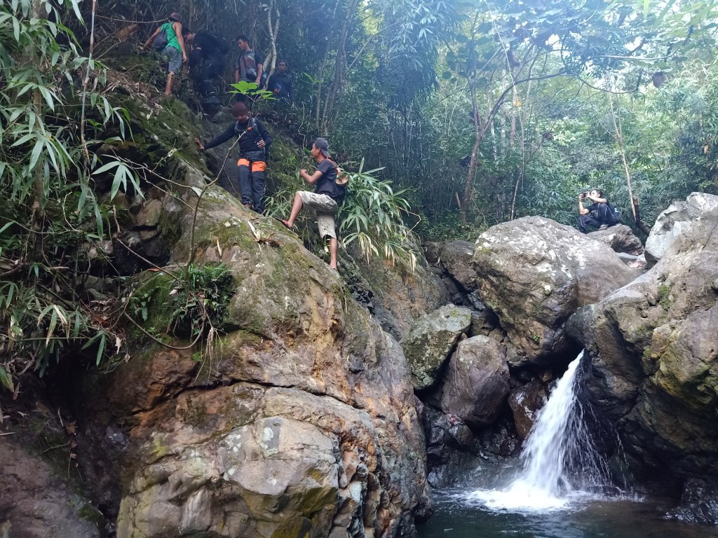
After minutes of resting, we continued with the hike towards the river trail. We further descended by the side of the kubo, until making a right turn that completely descends into the river bank. From here on, we would follow the whole river dotted with large rocks and boulders, which we would have to negotiate. For a good number of minutes, we were leaping from one rock to another, or merely climbing it using our limbs. It was completely a different hiking experience from your usual walk. I was panting like a dog at this point. Then, we encountered the first of the three-rock scrambling portions, where we had to crawl on boulders at the side of the river to descend. From the blogs that I saw online, guides would have to install a rope at those portions and then remove them afterwards. For our hike, I was shocked that the guides did not bring any ropes and just guided us to scramble them without any safety equipment! Talk about buwis-buhay. It was kind of dangerous since one misstep can lead you to stumble upon the rocks beneath you, and then to the shallow waters of the river below. Still, it was an exhilarating experience, and we managed to negotiate all three rock scrambling portions. I was already tired at this point.
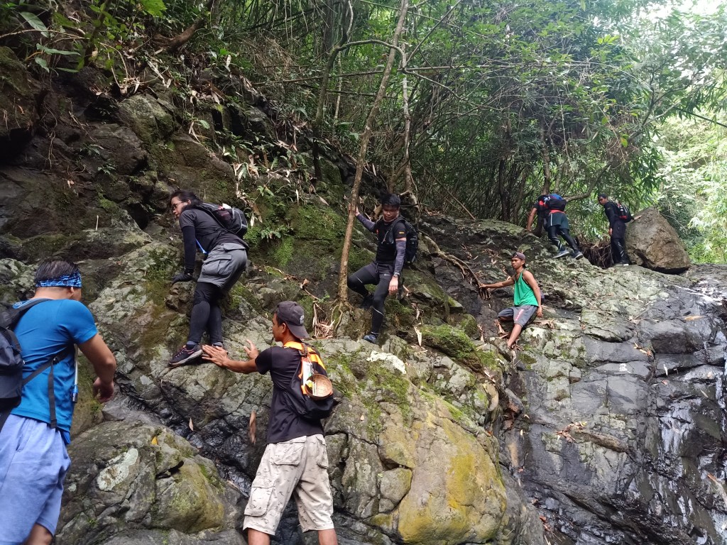
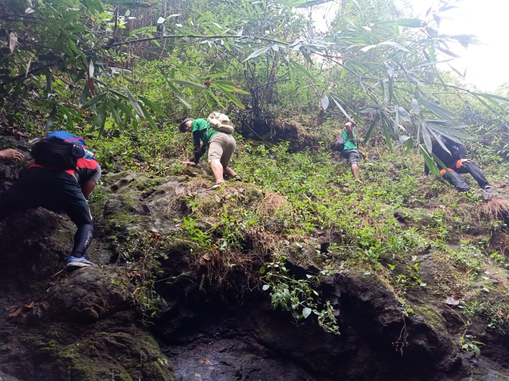
The whole river trekking took us an hour to negotiate. Then, at the left side of the trail, we spotted the start of the final assault towards the summit of Mt. Damas. Seeing the steep trail made me already pant inside my head (is that even possible? Lol!). We started the ascent after minutes of regrouping and resting. The initial portions of the hike were the steepest, where we needed to actually use the roots in front of us to scramble. Then, the sharpness of the steep slope disappears just after a few meters, but is still steep. This would continue up until the summit. It was reminiscent of the last assault in Mt. Natib and Tarak Ridge. At this point, I was mostly in the middle to sweep group since I was panting and stopping every few meters. I was truly unprepared for this hike.
Still, I was enjoying the aerobic activity as I was sweating profusely, maybe not just in the same quality if I were prepared. The forest around me was filled with bamboos, which I would sometimes hold for balance, since I was growing really tired. At the upper portions are shrubs and thick undergrowth reminiscent of our Mt. Malipunyo hike where we needed to force our way through the thick foliage of plants, that even if you were protected by your clothes, sleeves, and pants, would still irritate your skin. As I am writing this, I still have itchy marks on my skin coming from those thick plants!

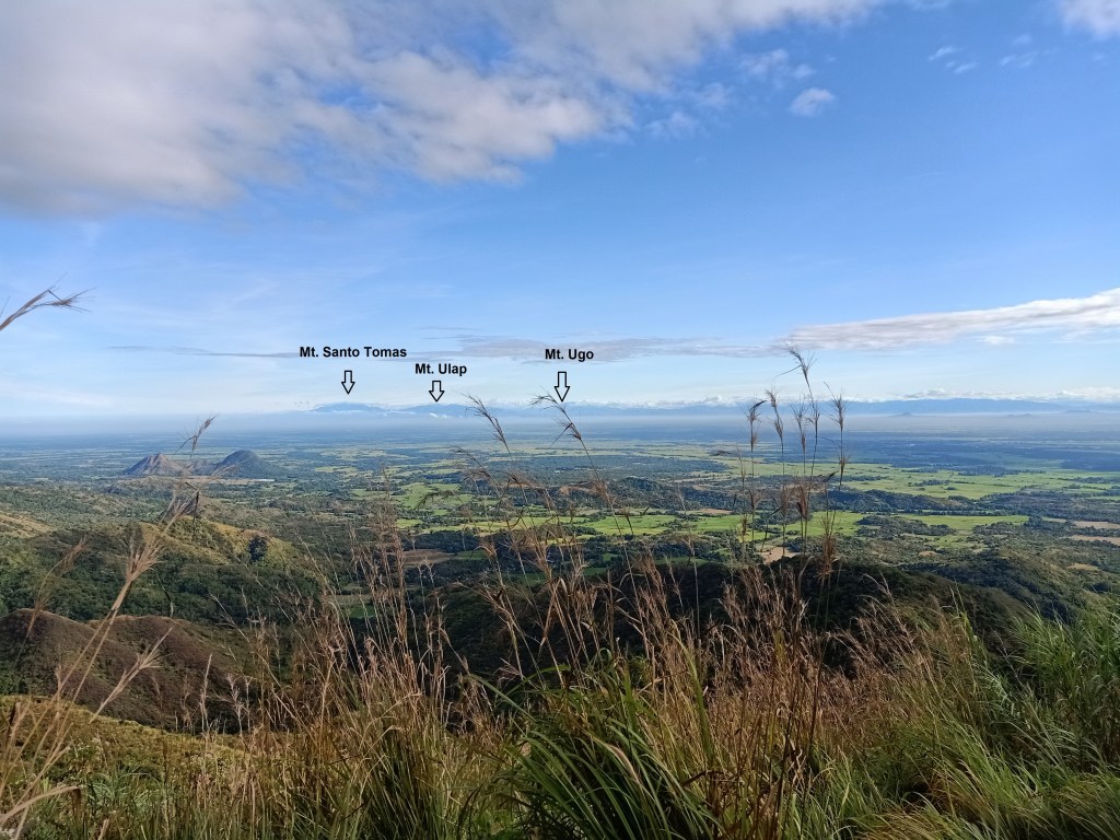
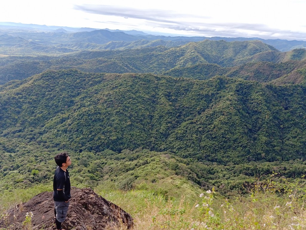
After an hour, I emerged into the viewpoint, where the other hikers were already there. I spotted the summit, which was just ten minutes from where we were. I joined the entire group and rested, appreciating the view in front of us. Time for a site orienting: to our left, which was north, was a large mountain blocking our view. This is said to be the town of San Clemente. The guide said that behind it, the coastline of Pangasinan and La Union can already be seen. To our northeast, I spotted three connected mountain peaks that extend towards east. I can assume that these three mountains are Benguet’s Mt. Santo Tomas, Mt. Ulap, and Mt. Ugo (their height corresponds with the height of the mountains I saw). To their right is the continuation of the southern tip of the Cordillera mountains that extends until Nueva Vizcaya, which was in our far front (east). To our near front, the fields of Tarlac and Pangasinan can be seen, with Mt. Amorong, Mt. Balungao, and other smaller mountains of Pangasinan. These mountains can be seen up close when passing by TPLEX. To my right (south) was the continuation of the Tarlac-Zambales mountain range. I needed to go higher to see the fields of Pampanga and Mt. Arayat.

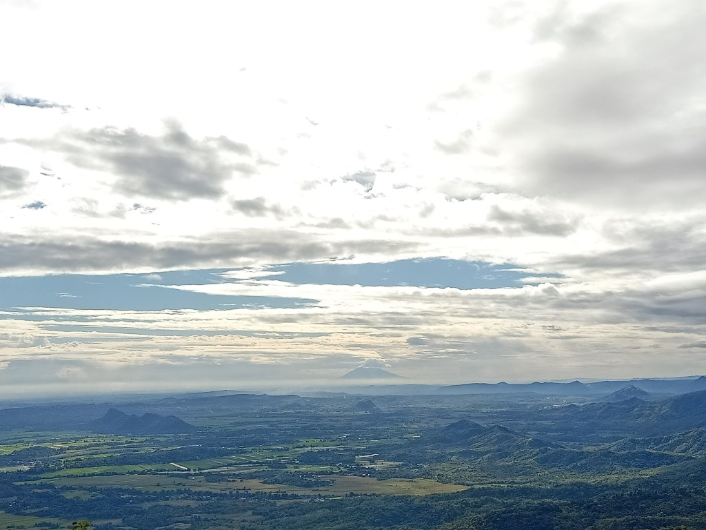
After a few minutes of resting, we continued the hike towards the summit. It was just a short hike to reach it. We even had a photo op session along the trail, with the northern view as background. Here, I can already spot Mt. Arayat as well as the range that comprises Mt. Pinatubo. The guide also pointed out the location of the San Jose Circuit, which I didn’t see because of the many mountain peaks in front of me. Then, we went at the summit area, where the western portion can be seen, completing the whole 360-degree view. The western part is comprised of higher mountains ranges, comprising of Mt. Semilya and other unnamed peaks. Since this mountain range is blocking the whole view, it’s impossible to see Mt. Tapulao and the continuation of the Zambales mountain range. Maybe someday, I would be able to do the Tapulao Traverse coming from Tarlac. I wonder if fate would let me!
We descended after having our snacks and photo ops in the summit. I was again with the last group since I was very careful in descending the very steep trail. My knees were already trembling at this point, and my hands were bleeding from holding the thorny bamboos as support. Slowly, I made my way through the steep descent, until arriving again at the river trail, where the other hikers were once again waiting for us in the last group. After a few minutes of rest, we went towards left of the steep trail, which was the continuation of the river trail. This river path goes directly to our next stop for the day – the famed Ubod Falls.
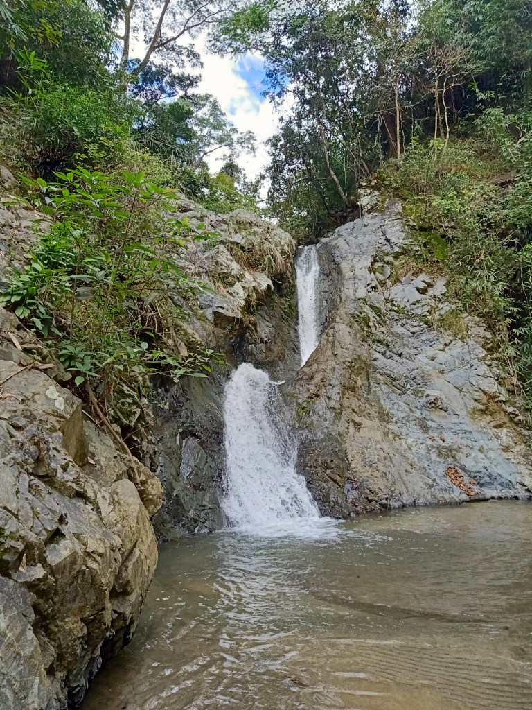
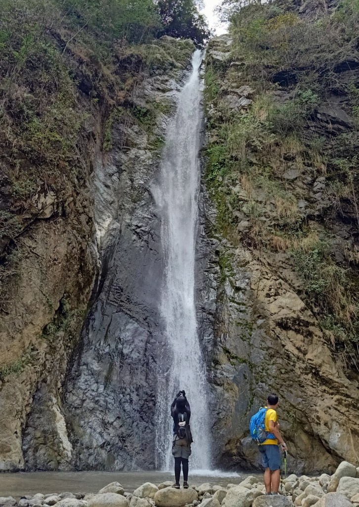
Despite my tired body, I felt excitement as I passed by the same river trail dotted with large rocks. Just after a few minutes into the hike, we reached Si-el falls, which has a J- and C-shaped downward stream. What was thrilling about this part was that we needed to climb the boulders beside the falls! Afterwards, it was just a short minute walk (again, through the large boulders of the area) until reaching the forty-meter high Ubod Falls! I was stunned upon seeing it, but since I was tired, I just retired at one of the boulders and lay down, while the rest of the group took pictures. There, we took our lunch and bathed at the shallow waters below the falls. We even used the falls as a shower! It was the first time I did that, being the scaredy cat that I am when it comes to deep waters.
Spending a few good hours around the falls, it was then time to say good bye. With our wet bodies and relaxed muscles, we negotiated the second cardiac trail of the hike. After backtrailing for a bit, we made a left turn. This cardiac trail, which was another round of steep assault, would go on for fifteen to thirty minutes, which then turns into a descent. This trail was made in order for hikers to avoid the three-rock scrambling segments of the river trail. At this part, I was already feeling cramps in both of my knees.
After a few minutes, we emerged into the river trail once again after descending. A few minutes, we were back at the kubo. I sat and rested my tired body.
It was still an hour of hike before reaching the jump-off point. I was left with another member of the sweeper group and a guide as the rest of the group already made their way into the trail. My cramps weren’t at all fading, and I needed to have a bamboo stick as a support. Still, I walked slowly despite the aching sensation. It was nonetheless an enjoyable walk, albeit a long one. It reminded me of the descending portions of Mt. Natib. After an hour, I reached the jump-off point, where I hurriedly cleansed myself and brought something to eat. I was tired, but felt accomplished in finishing this arduous mountain hike. Mt. Damas was indeed ferocious.
We left Papaac around four in the afternoon, and had our celebratory late lunch/dinner at City Mall in Tarlac City. Then, I reached Malolos City around seven in the evening, completing this one whole day, and the year 2019, of challenging and rewarding hikes.
On to 2020!
Itinerary
Day 0
10:00PM Meet-up at McDo Kia Theatre Cubao
11:30PM ETD to Camiling, Tarlac
Day 1
02:30AM Barangay Papaac Registration Site, rest
05:00AM Start hike
06:00AM Kubo, rest
06:15AM Resume river trek
06:45AM Start of rapeling
07:15AM Start of assault
08:15AM Viewdeck, rest
08:30AM Continue assault to summit, photo ops
08:45AM Summit
09:30AM Start descent
10:15AM End of cardiac trail, rest
10:40AM Si-el Falls
10:50AM Ubod Falls, rest and lunch
12:00PM Return to jumpoff, cardiac trail
01:00PM Kubo, rest
01:30PM Resume trek
03:00PM Jump-off, tidy up
05:00PM Tarlac City, dinner
08:00PM Malolos, home
