The year of 2018 has been fruitful for my mountaineering career as it has been the season in which I ventured into my first major climbs where the terrains and trails are more difficult and technical, but nonetheless mesmerizing and fulfilling. Mts. Arayat, Purgatory, Tarak, and Amuyao have now been crossed out of my list; Tapulao, Ugo, Napulauan, Pulag, and other Luzon grand mountains are soon-to-be listed out. It was this year when these mountains turned into a self-extension; my identity became attached to them as they are close to my hometown, and that some of them, especially those in the North, felt like a humble grand abode whenever I tried to visit them. These mountains have now become a part of me.
It was November of 2018 and the year is almost ending. The mountains still to be ticked off in my bucket list are to be pursued for 2019 as the two months left for this year would not be enough logistically (and financially) to fit into my schedule. Still, with the time left, I was planning to do a Luzon 321 or an Ugo Traverse as a year-end climb. Apparently, the North enticed me with something lesser known than what I aspire to climb, something that Climbers rarely hear and go to – the Viscayan towering mountain that is Mt. Palali. For this climb, JM, my college buddy, and I joined an event by Deya (aka Diwatang Gala), the organizer whom we joined with in our Tarak Ridge climb.

Standing at 1715 MASL, Mt. Palali is situated in the landlocked province of Nueva Viscaya at the quiet town of Quezon. It is easily accessible through the highway in Solano, where a tricycle ride to the jump-off point can be easily arranged. We rendezvoused at McDonald’s in Kia Theatre in Cubao, where we departed at around 10 in the evening of November 10. We arrived in Solano at around 3 in the morning, took our breakfast at McDonald’s and made our final preparations there. We also bought last-minute supplies at a nearby 7-11 store. Deya informed us that the barangay allows mountaineers to start hiking at 6 in the morning, so we really took the time to prepare while still in Solano. Meeting our guides at McDo, they led our van to go to the jump-off point, which is situated in Barangay Maddiangat. We arrived there at around 5 in the morning. Our van driver dropped us off so that he can go to other side of the mountain where Mapalyao Falls – our exit point – is located. We made final preparations and orientations before starting the hike. We started at 5:30 in the morning.
The trailhead is comprised of a suburban house where its rural vibes can be felt, as it is in the middle of a forest at the foot of the mountain. The jump-off point seems to be in high elevation, much like in Arayat and Tarak where the fields below the mountain can be seen from afar. We, then, walked towards the back of the house where an ascending pavement greeted us with a fiery warm-up. The pavement was steep and stretches for over a few meters. It reminded me of the initial ascent in Mt. Ulap, only this time, the road was steeper and longer. One by one, our companions marched forward, leaving JM and me at the back. I was already panting from the cardio work out early on. The cemented path then came to an end, and brought us to a wide trail where to our right, a view of a nearby grassy knoll can be seen, and from afar, the stretching mountain range of Kayapa, Nueva Vizcaya where Mt. Ugo resides. The trail zigzags, turning leftwards and then rightwards as if we were circulating the giant mountainous area. Trees can already be seen at this part.
The trail slowly became narrower as we treaded along. My tummy was signaling my mind bouts of distress due to the coffee I consumed at McDo earlier. It was like I was about to puke the second I expedited my pace. Slowly, I continued walking until entering the forested part of the mountain, where trees environ the place. It eventually led to a campsite where tents were pitched and hikers were greeting us a good morning from their warm stay there. The lead and the middle group were also there, waiting for us, and checked if I was okay. A few minutes of rest, they continued the hike. I followed them, but of course, with my slow moving feet, I let myself tread gradually with our patient sweep and JM, and our guide.
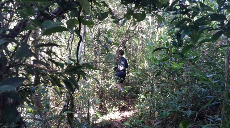
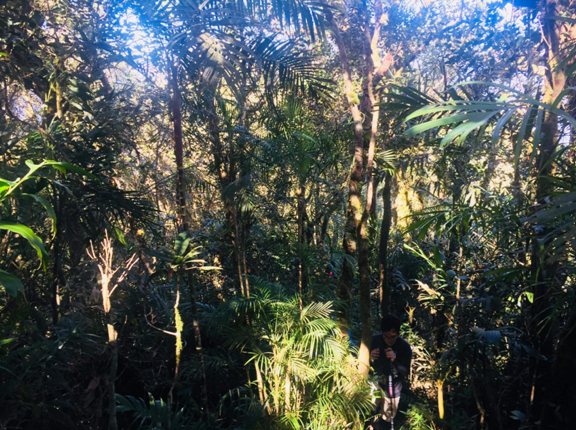
Ascending, the surroundings reminded me of the forests of Arayat and Tarak Ridge, only this time, the forest was thicker, and the undergrowth more diverse. The assault was long, as if each slow step I took only led me a few meters. I became easily tired and dizzy. Our sweeper, who was very patient, took the time to entertain us with chitchats and conversations. After an hour of ascent, giant boulders occasionally show up, indicating that we are near the half-point which is Haring Bato. An hour of walking, through the very thick forest and passing by giant boulders, we reached Haring Bato at around 8:00 in the morning, after 3 hours of negotiating the thick blessed forest of Mt. Palali.

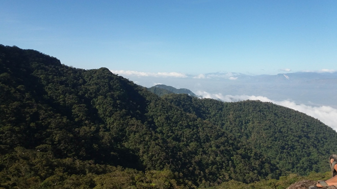
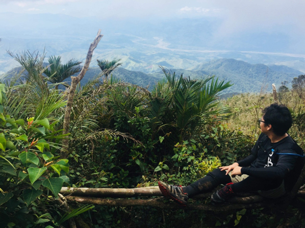
Atop of Haring Bato, we can see the dense forest we passed by; each tree comprises of very distinct leaves, indicating the diversity of the flora of the forest of the mountain. Beyond that forest, the view paved the way to a very picturesque field where the towns of Nueva Vizcaya can be seen, with Magat River slithering beside. Bayombong, Bambang, and Solano are the only ones I can identify. Behind those towns, even from afar, the mountain ranges of the Cordillera can be seen and appreciated. To our southwest was Kayapa, where the view can only be assumed as Mt. Ugo. To our northwest is another gigantic mountain range which is said to be the town of Ambaguio. This town is one of the four jump-off points of Mt. Pulag, and indeed, the saddle portion of Luzon’s highest summit can already be seen atop of Haring Bato, although obscure. To our north northwest, gigantic peaks also dominate the view, in what I can only assume as Amuyao, Napulauan, or Kalawitan. Our guide told us that that direction points to Banaue, Ifugao. To our north, north northeast, and northeast, the Sierra Madre mountain range can be seen. At our east is the continuation of the higher portions of Mt. Palali, where the summit deceptively hides at the back of the ridge. Mt. Palali reminds me of Mt. Mariveles, where the whole mountain complex is really huge, and that each ridgeline can already be considered a mountain itself. This is truly an amazing place to hike.
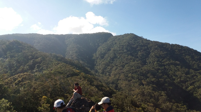
We had our breakfast at Haring Bato where everyone is seemed to be hungry after the long arduous ascent. We also snapped photos, individual and group, with the very quaint view. Our companions also jammed to some Queen songs – Bohemian Rhapsody (the movie) was just recently released, and the hype was even brought to the mountains! While jamming and taking our time to rest, I was certain that I can already feel cramps and tiredness in my legs. I remembered the panting and tiredness that I felt going to Haring Bato and prayed to God that I may be able to summit the mountain without complications and unwanted happenings. After munching on some Wiggles, our companions departed Haring Bato to push forward towards the summit.
At around 8:50, we departed Haring Bato. Joining us in the sweep was our organizer, Deya, who was initially with the lead group. After leaving Haring Bato and marching for a few meters towards a thicker montane forest, I let out a scream so loud that the avian species found in Mt. Palali may very well be extinct. I got very sore muscle cramps in my right knee, yet I did not even fall or tumble! I was just hiking at a normal pace when suddenly, a pang of pain jolted in my knee so sudden that I was immobile for minutes. Screaming, JM, who was advancing for a few meters, went back to see what was happening. Thankfully, Deya and Sir Nash (our sweep) aided to my concern. They gave me a knee support and performed some first aid protocols. I sat there for a few minutes, with my company making the situation lighter and bearable. With the pain in my knee, I was advised to discontinue summiting the mountain and eventually make a left turn at a junction where the trail descending to the falls would be found. I was considering it, and maybe just have a revenge climb some time in the future. I wouldn’t really want to be a burden to the team, so I agreed
Walking towards the junction, thoughts raced in my head. Although the sweep team was accommodating enough to care for my concerns, I was ruminating about the thought of not quitting and taking the risk of summiting the mountain. Slowly, as I kept myself busy with walking and contemplating, the pain in my knee slowly faded. Nearing the junction, something inside me rekindled, as if a fire put out by cold was poured with gasoline. The thought of not summiting Mt. Palali was an unwelcome thought, and that what pride would I get if I never got to finish this climb? I reminisced on stories of superheroes, fictional characters, and heck, even mountaineers who conquered their struggles in order to finish what they have started – in order to reach the goal they have set themselves to do. And I was exactly in that situation! This pain was just a test, just an obstacle that will test my character and virtues. No, I will not quit! I will push for the summit because this is what I was born to do! At the junction, I exclaimed my intent to summit the mountain. I expressed that I can do it, and that I can push forward. I also advised Deya to push forward if she wanted to, but to my surprise, she pointed out professionally that as an organizer, she needed to be in the sweeper group and that I needed someone who can push me forward towards the summit. I was thankful. I was in good hands.

Slowly, I treaded forward towards the trail going to the summit. The trail has been continually flat, with only a few ascents. Still, this portion was really long and it seemed never-ending. The forest was only getting thicker and thicker and wilder and wilder. We passed by two very pristine brooks. We pushed forward, the forest now transforming into a wilder moss-filled milieu. Mosses now dominate each tree, and it reminded me of our Cordillera pursuits. Just like in Purgatory, this mossy forest seemed to never end, but it was indeed very beautiful – mesmerizing perhaps. Deya prohibited me into asking questions about how faraway the summit is from where we were and how many hours or minutes it will take to reach. That was some professional motivating right there. Deep into the forest, the wild was very much abundant. Fallen trees needed to be negotiated. Not only that we needed to walk through the plant-crowded surrounding, but we also needed to crouch, jump, duck, climb, and make very technical moves to pass by fallen trees. Sometimes, the trees even contain very colorful mushrooms. In fact, this may actually be the most diverse floral environment I have ever stepped on!
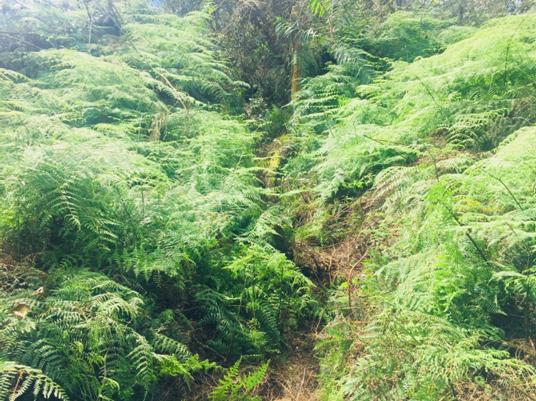
Marching forward, the motivational fiery pursuit became a cascade of doubts. Why was I pursuing this anyway? Will this end? Can my knees bear any longer? Slowly, I treaded on the wild trail. I was now losing my consciousness. I was tired, exasperated, and even perhaps dying (kidding). I got to a point where I was just walking like a zombie – non-conscious and automatic. Will this end? Sometimes, I even had to push myself up in order to march forward. I was looking beyond the trees to see if there is an actual summit in view, but there is none. Starting from Haring Bato, I could only see thick foliage of trees, no bearing high ground where a possible summit can be viewed. This was amazingly scary. I was also mildly visually hallucinating. Animals and persons seemed to be at my peripheral when in fact there is none. After passing through possibly three sections with no overgrowth, we walked towards another thickly-filled forest where after a few minutes, we heard voices – and this time I was sure that it was not a hallucination! It was 11:15 AM, more than 2 hours of negotiating towards the summit! I was greeted by a cheer from our companions. Thank you.
The summit was forested, where only one group of van passengers can be cramped in its small area. It had a view deck composed of a high makeshift bamboo bench where one can sit down. It only gave a limited view of the surrounding. JM and I took our pictures there and ate our lunch together with the group. I, then, chitchatted with Sir Nel, one of our companions about Queen while taking our lunch. I munched on our usual McDonald’s crispy chicken sandwich. I also saw a very small limatik on my trekking pole which was hastily crawling upwards towards the skin of my hands. I just shrugged it off and placed my pole beside the thick plantation. It did not bother me, thankfully. At around 1700 meters above sea level, the air was unsurprisingly cold, yet we were astonished because the sun was quite up at that time. Sir Nel was telling us that they were just resting in that place when they were shocked that one of our companions told them that it was the summit area.
Past 12 noon, our companions departed. Deya, Sir Nash, JM, and I stayed there for a little longer. Then, we departed, too. Backtrailing towards the junction, I was able to re-appreciate the thick mossy forest. We regrouped in the second brook where we refilled our water supplies and rested there for a while, while the rest of the team went ahead. Upon reaching the junction, we turned right towards a very thick forest. Long walks, exasperating forest treads, an hour of scrambling took us on that section, which eventually led to a descending portion of the forest. This descent, just like any portion of the trail, was very long. Thankfully, I was able to regain my strength. I was now able to move quickly and run downwards. Some sections of the descending portion, however, were very slippery. I needed to actually slide down for a few stretching meters to go down. That was fun, but also dangerous! Well, dangerous is fun.
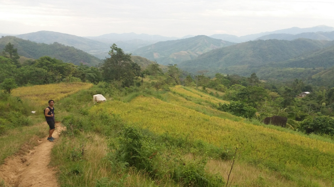
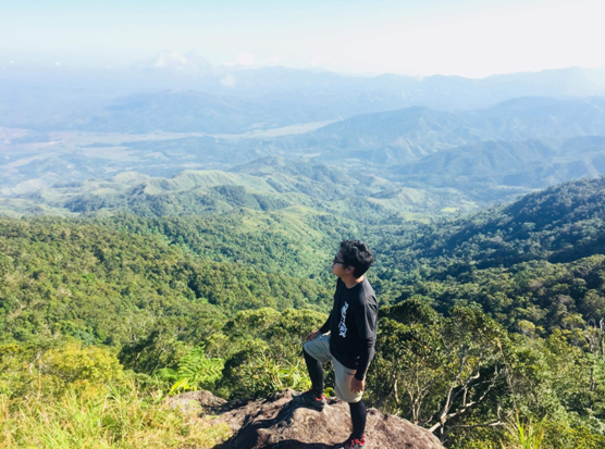
It was 2:30 in the afternoon when we exited the forest, which then gave way to a grassy and wide footpath. The elevation, however, was still high, maybe around 800-1000 meters above sea level. Descending the footpath, we found ourselves in another long walk going towards our destination. Just like the montane forest above the mountain ridge, this section seemed to love to play with our minds and knees. Still, the view was magnificent. Facing east, we were greeted with the Sierra Madre mountain range. Several unexplored summits welcomed us. At our back, Mt. Palali’s forested ridges can be seen. The summit area, however, was hiding behind them. We, then, reached terraces of rice plantations. It was very beautiful. It then led to an unpaved descending road where village locals reside at the side of it. We were greeted with locals along the rural area, and dogs barking at us unknown visitors. We continued walking towards the long winding road. Then, just as we were reminiscing on our excruciating steep descent towards Bokod municipal hall in our Mt. Purgatory hike, we were greeted with a similar pavement going downwards.
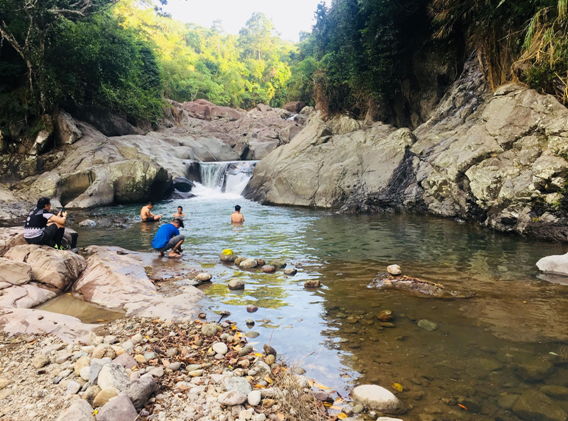
Sir Nash and the guide left us and expedited their pace. JM and I continued walking on the paved road where our knees where battered, reminding me of our torturous descent in Mt. Purgatory. The road came to an end when it diverged into two, the right one reading to Mapalyao Falls. Taking the right turn, it was only a few seconds when we reached the falls. There, our companions were settling, and some were already taking their swim at the lagoon near the falls. It was almost 4:15 in the afternoon. JM and I took the chance to bathe at the cold waters of the lagoon. We, then, settled and eventually left the place, meeting our van at a nearby area. We took our baths and went home. At around 06:30, we were at Solano, taking our dinner at a local restaurant, celebrating our success of traversing Mt. Palali and celebrating Deya and JM’s birthday climb.
Mt. Palali proved to be one of my toughest and wildest hikes yet. Although the hike to and from the summit does not contain any steep sections, the trail was very wild, technical, and very long, possibly stretching for up to a total of more or less 20 kilometers, with diverse species of plants welcoming you as you tread along. The bottom part of the mountain reminds me of our Arayat and Tarak Ridge climb, while the upper portion is reminiscent of our Purgatory hike with its thick and eerie mossy forests. This combination of two regional characteristics, where Central Luzon’s rain forest and Cordillera’s mossy forest synthesize in one mountain, is what makes Mt. Palali distinct from other mountains. I hope more and more mountaineers discover this serene place, and that the local government can keep its beauty and wilderness. Despite not being originally in my bucket list, Mt. Palali proved to be one of my top-tier hikes for 2018!
Itinerary
Day 0
09:00PM Meet-up at McDonald’s Kia Theatre, Cubao
10:00PM ETD Solano
Day 1
03:15AM McDonald’s Solano, breakfast, prepare
04:45AM ETD Baranggay Maddiangat
05:30AM ETA Baranggay Maddiangat, commence hike
08:15AM ETA Haring Bato, rest, take pictures
08:50AM ETD Continue hike towards summit, mossy forest
11:15AM ETA Summit, lunch, take photos
12:00PM Departure from summit, descent backtrail
01:00PM Rest at water source, continue descent towards the junction
01:15PM Junction, descent
04:15PM Mapalyao falls, end of hike, bathe
05:00PM Clean-up, prepare for departure
06:45PM ETD Solano, dinner
07:30PM Departure from Solano
01:00PM Plaridel, Bulacan
02:00PM Home
