Last December 2, 2018, I was invited to join The Chill Trekker’s Mt. Irid dayhike in what occurred as one of my most intense climbs yet. Jaayem, the group’s organizer, actually informed me about the hike several months before December. She stated that the group only occasionally organizes climbs to Mt. Irid because of the logistic difficulty in securing permits and transportation as the mountain is situated at a very secluded area in Rizal. Weeks before the climb, I agreed to join. I am usually with my long-time hiking buddy and college friend JM on these extreme kinds of hike, but I knew he was busy at that time, so I went solo. Mt. Irid proved to be a test of faith and patience, something you would expect on Rizal’s highest point.
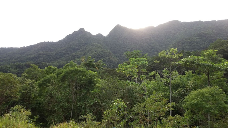
Mt. Irid, standing proudly at 1467 MASL, is situated in Barangay Sta. Ines in the town of Tanay in Rizal. It is the highest point in the province and can actually be viewed from the other mountains in Tanay. True enough, when JM and our college classmates hiked Mt. Batolusong a year ago, we spotted this gigantic mountain from afar. There, I marked my words that someday, I would be fit enough to climb the grand mountain. Pinoy Mountaineer rates its difficulty as 6/9, and is usually hiked for two days, but can be done as an extreme dayhike. Moreover, its accessibility is as difficult as the hike, as vehicles need to cross several streams before reaching Sta. Ines. The mountain’s main features consists of 11 river crossings one needs to negotiate before reaching the foot of the mountain, coupled with a very long ascent at a thick rain forest going towards the summit. I knew before then that this will be one of my most extreme hikes this year.
The group met at McDonald’s Kia Theatre in Cubao at around 10 in the evening. I was actually an early bird at that time, arriving before 9 o’clock. At around 11, we rented a van going to Cogeo Gate 2 in Antipolo City, where the ride only took us less than an hour. There, a jeepney bound for Sta. Ines was waiting for us. The wheels of the jeep were large – perfectly suited for the stream crossings. We climbed aboard the jeep and departed Antipolo City at around 12 and crossed Marikina-Infanta (Marcos) highway, turning a left detour towards Sta. Ines Road. We passed by Mt. Batolusong’s jumpoff area, and from there, the road started to get bumpy. None of us got the chance to sleep throughout the ride, as our jeep turned into a carnival trip going to Sta. Ines. We passed by several streams until reaching the barangay hall of Sta. Ines past 2 in the morning.
Since our hike was still scheduled at 3:30 in the morning, I took the chance to sleep inside the barangay hall and get some ample rest. Then, I took a hearty breakfast at a gotohan at a nearby carinderia. After finishing my bowl of lugaw with egg, the group started the orientation. It was drizzling at that time. We offered a quick prayer, followed by our guides giving several reminders about Mt. Irid. Out of all their points, one thing that stuck in my memory was the huge possibility of finishing the hike at nighttime. Questions started to appear in my head: was it really that long? Can we finish it before sunset so that we could get home early? Can my headlamp, whose batteries have been used extensively in my previous hikes, work that long? All these questions lingered in my head, but I had no other choice but to go on with the hike. I was about to find out.
We commenced the hike past 3 in the morning. Leading the group, we walked towards a gravelly road, where several houses dotted beside it. Everything was dark at that time. We could only see the road ahead of us lighted by our lamps, and the night sky stretching infinitely from above. I was thankful my headlamp was still working well at that time. I used to get dizzy doing dim trekking, so a well-lit pathway is a necessity for my fragile eyes. The road, then, turned narrower, but still wide enough for us to walk. Rocks and boulders now started to appear. The drizzle stopped, so I took off my rain jacket. We treaded until reaching the first river crossing.
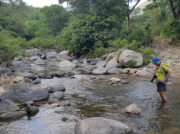
The second, third, and the succeeding river crossings greeted us with one of Mt. Irid’s resident creatures: limatik (blood leeches). This blood-sucking animal attached themselves on the foot of several of our companions. I did not bother to check mine, as I would rather occupy myself with the long walk. And yes, it was indeed a very long walk. The only consolation for that part was the trail was all flat. There were no painful ascents that would beat the hell out of our knees. Still, it was tiring given the length of the walk we just did. Passing through the 9th river crossing, we found ourselves at Sitio Kinabuan past 4 in the morning, two hours earlier compared to the proposed itinerary.
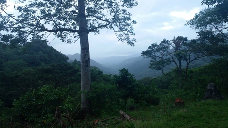
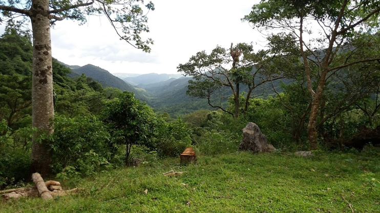
We took an ample rest in Sitio Kinabuan, munching on trail food and having our water breaks. A few minutes into our rest, something bothering occurred – rain started to pour. What an unwelcome surprise! I put on my rain jacket once again and munched on wet trail foods. Still, we pushed through as the rain was only mild, and it wouldn’t make the river swell at all. It also stopped after a few minutes. We then passed by the 10th and 11th river crossing. Thankfully, there were only mild ascents at that part and the trail was mostly rolling. Just as the first faint sunlight appeared, making me turn off my dim headlamp, an ascent ensues. Testing my knees, I went slowly. We passed through a rainforest until reaching a grass land. Here, Mt. Tukduang Banoi which is usually coupled with Mt. Irid, can be seen. Sunlight was now up. Going straight, we reached Sitio Sadlac at exactly 6 in the morning, almost 3 hours after commencing the hike!
We took a very long rest at Sitio Sadlac. The place, which was the choice of camping ground for most hikers, had a few huts that served as resting places. Tents were pitched at a nearby ground, its owners still sleeping inside. A sari-sari store was luckily open; our companions bought instant noodles for breakfast. I ate my trail food and had my bowel business done. The surrounding was very beautiful. Hanging Amihan was making her presence felt; the wind was comfortably cold, making us all drowsy from the lack of sleep we have. Some of our companions were attending to their limatik bites. Sir Karl, another solo joiner I befriended during our ascent, had a blood-filled leg at that time. Others, too, had several bites on their feet. To my surprise, my feet were actually spared from the horror – no bites at all! I privately insisted that I would be limatik-free since ’96.
We left Sitio Sadlac at around 7 in the morning. Nearing the foot of the mountain, we entered a rainforest filled with dipterocarp trees reminiscent of our Arayat and Tarak Ridge hikes. After half an hour of ascent, we reached a mini-grassland area where a hut is placed. We took the chance to rest there and regroup. Rain, however, started pouring again. It was stronger than the previous drizzles, but our coordinator insisted we push through. The group left, leaving me with the rest of the last group. I hurriedly put my rain jacket and pushed through with the hike.

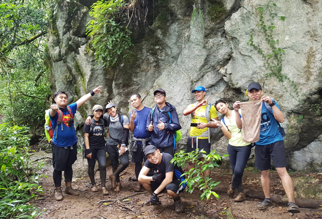
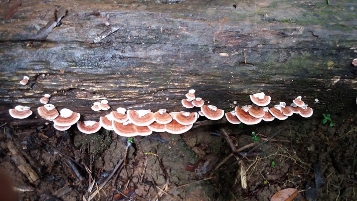
Entering the very thick rainforest of Mt. Irid, we ascended the wet pathway. It was very similar with that of Tarak Ridge, where roots serve as stepping ground for ascending the trail. The variety of flora was evident. Lushes of different plants and trees were present. Lipa and rattan can also be seen, as well as plants I cannot identify were scattered throughout the slopes. I took the time ascending with the last group, but then after a few minutes, I advanced and caught up with the lead group. The trail continues to go upwards until reaching the first marker in the hike called as “Rock 1” – a giant limestone boulder in the middle of the rainforest. Here, we took some ample rest and waited for the middle group to catch up. We munched on our trail foods again. It was past 8 o’clock in the morning.
We pushed through with the hike, reaching Rock 2 just minutes after ascending from Rock 1. Our guide indicated that this was the half-point of the ascent. We actually had to negotiate with the giant limestone boulder to go up, reminiscent with the limestone trails in Binacayan. Afterwards, the trail continues to stretch upwards in the rainforest. There were some flat grounds, but the whole ascent did not have any resting place. It was a straightforward assault, which very slowly, gets steeper as you gain elevation. We passed by another rock formation. We went through beside it, the guide telling us that this was a new trail. The old trail was supposed to lead us to Rock 3 and 4, but that trail was damaged – possibly by typhoons – and that it was a lot steeper and more perilous than the trail we were treading.
There were nine of us in the lead group, six of us advancing on equal speeds. The trail was very steep, each of us taking short breathers every few meters. Our guide tried his best to minimize rest so that we could reach the summit by 11 AM. Still, with our energetic pursuit, the ascent was exasperating. The slippery mud made the assault more difficult. There was one time where I almost tripped, but was saved by my companion behind me. The assault went on and on, reminding me of Mt. Palali’s trail length. It was then when I found out that I had limatik on my foot. I quickly borrowed alcohol to remove it. We continued the ascent, and it seemed to never end. The trees are now covered with moss. And that is when I found out that I was bitten – I had a stain of blood on my right, muddy foot. I did not mind it. It was inevitable since one, it was raining; two, we were in the upper reaches of the mountain; and three, we were now in a mossy forest. It was mesmerizing how we did not even notice how the forest transitioned into a wet rainforest into a mossy one.
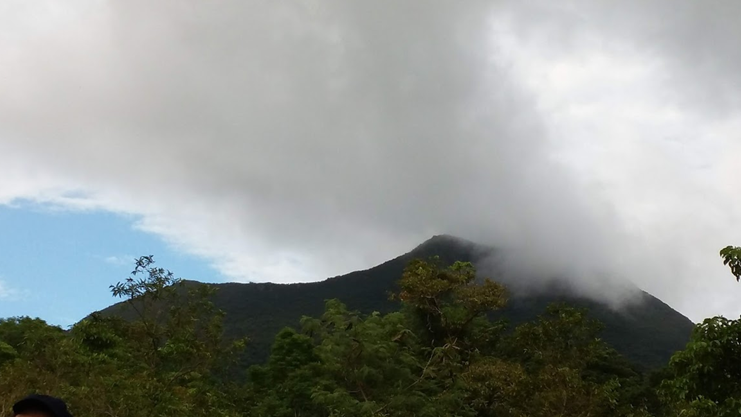
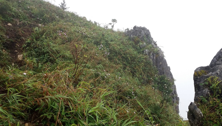
There were six of us who reached the summit at exactly 10:45 in the morning – 7 hours after starting the hike! The area is composed of sharp limestone rocks where the supposed view is facing west. Due to the rain, we had no clearing above. It was also drizzling – the rain smacking our face with that Amihan force. It was kind of disappointing to not have a view at Rizal’s highest point. Hiking blogs often show its magnificent view from above – from Mt. Tukduang Banoi and other Rizal mountains being dwarfed by Mt. Irid, Laguna de Bay behind those mountains, and the Banahaw Complex from afar – all those views were covered by misty white clouds. It was a sad view. Still, the pride of conquering the grand mountain was an achievement in itself. 2017 me would be so proud!


One by one, our companions reached the summit. After taking some pictures, we decided to go back to the forest part of the summit since it was drizzling, and the wind was blowing strong. We retired at the back of the limestone rocks at the back of the summit facing the forest. There, we ate our lunch despite the biting cold. With Hanging Amihan blowing very strong, and us being wet from the rain, we were shivering from the cold! I ate my packed lunch – a leftover stuffed crust pizza from last night’s dinner. I only ate one slice because it was so hard to eat while shivering. Thankfully, our coordinators brought emergency blankets because I was sure enough that some of us would experience hypothermia if we spent longer minutes in the summit area.
We told our coordinator that some of us should go down immediately, as the cold was really unbearable. Sir Karl and the rest of the lead group immediately joined us going down. Backtrailing, we found the path was a lot harder to descend than to go up because of the slippery mud. As we were descending, I found blood stains on my feet. I didn’t even notice I was bitten! I shrugged it off, because while continuing to descend, much of my feet were covered with mud. It also wasn’t helping that the straps of my sandals were malfunctioning, so I really had a hard time controlling my footwork. My shoes could have saved me from these. We took a long rest at Rock 1, continuing the descent afterwards and then exiting the rainforest past one in the afternoon. We took a very long rest again at the hut until we started descending to Sitio Sadlac, arriving there after 2PM.
We had a very long rest at Sitio Sadlac that afternoon. I took the chance to clean my mud-covered legs and wash my extremities. There, we waited for the middle and last group to arrive for over an hour. We took the time to chitchat and eat pancit canton and drink Coke to pass the time. It was a very tiring hike! One by one, the middle and last group caught up. Just arriving shortly, we decided to push through with the descent to maximize the time we have left before sunset, leaving the rest of the group to have their ample rest at Sitio Sadlac. We descended at 3:30PM, hoping we could reach Sitio Kinabuan an hour later.
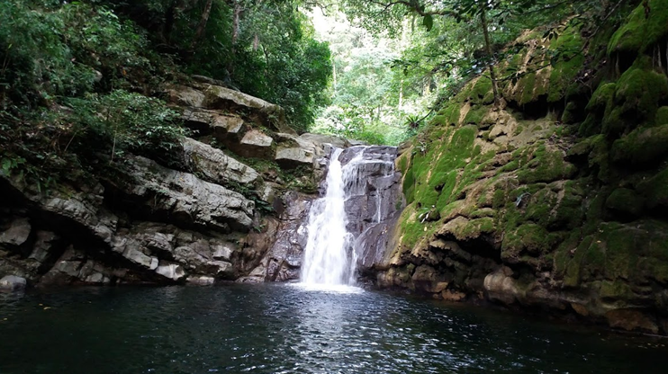
The trail between Sitio Sadlac and Sitio Kinabuan was a sight to behold. We did not get the chance to see the magnificence of our surrounding earlier due to darkness. It was astonishing! We were walking on a rolling gravelly path, beside us is a field of green and near it are mountain slopes. We crossed the 11th and 10th river, until reaching Sitio Kinabuan past 4 in the afternoon. The place was filled with locals living their usual lives, playing pool, attending to their chickens and horses, and carrying supplies. There, we took a left detour going towards the majestic Kinabuan Falls. It only took us less than five minutes to reach the lagoon. There, I took the chance to wash (again) my leggings, sandals, and my mud-filled shorts. Only a few of us took the chance to dip into the water, as most of us already wanted to descend. We also found out that Sir Karl and Sir Andy (another companion I socialized with in the lead group) were left behind and possibly went straight to the jumpoff point. Thankfully, one of our guides followed them.
It was 4:30 when we decided to start the descent back to the jumpoff. It was then when the middle and last group arrived at Sitio Kinabuan. Saying my farewell to the falls, the six of us in the lead group led by one of our coordinators, Sir Dandy, started the hike towards the jumpoff. Backtrailing without a guide (he waited for our three companions in the lead group who bathed in the lagoon), we marched hurriedly towards the jumpoff point. I was leading the group. I was speeding towards the trail as I wanted to go back while there’s still sunlight. Still, with the length of the trail, darkness caught up to us. We took a 10-minute rest before going through with the hike. I opened my dimly-lit headlamp. I had a hard time negotiating the rocky trail as I had a hard time seeing what was in front of me. I was also slowing down but thankfully, Dandy let me lead the group just behind him, so that I can have a light source at my front and at my back.
Darkness completely fell and it was still a long way to go. We were speeding, but I knew we’d be faster if I just had a functional headlamp. Still, we tried our best to go faster. We lost count of the rivers we just crossed, and I was already feeling the tiredness in my body. It was also difficult to track the succeeding trail at the other side of each river, but thankfully, our companions were skillful enough to track them. We would probably be lost without their navigating skills and their well-lit headlamps. I was already getting satiated with the long walk. Good thing, though, was that the last of the river crossings weren’t that far from each other, and that we recognized the trail after crossing the last (first) river crossing. A few hundred meters of walking, we reached the wide gravelly road. Locals greeted us, their houses now lit with bulbs. We were shocked that there were houses there, so we asked a few locals to confirm if we were in Sta. Ines. A few minutes of walking and turning right, then turning left, we reached the barangay hall at 6:45 in the evening – almost more than 15 hours after commencing the hike!
Resting for a bit at the barangay hall, we found out that Sir Karl and Sir Andy were now taking their dinner and bath at a local’s house near the barangay hall. They finished the hike at exactly 6PM. After we’ve arrived, the guide with three of our companions followed, reaching the barangay hall at 7 PM. We all went straight to the local’s house to take our baths there. They also cooked tinolang manok for our dinner. Unlimited kanin and unlimited sabaw for only a hundred pesos! It was such a comfort to the soul taking sips of that tinola broth. One by one, the rest of the group arrived. Past 9 in the evening, we climbed aboard the tall jeep and made our way to Antipolo City. We arrived there at around 11 in the evening before riding another jeepney that directly goes to Cubao. There, we went our separate ways.
Mt. Irid proved to be one of the most intense mountains I have hiked for this year. Unlike your typical Rizal mountain, Mt. Irid has a very technical and lengthy trail. Preparations are a must before hiking this mountain. Its trail length is said to be at par with that of Tapulao and Ugo, almost spanning for 30 kilometers. Its 11 river crossings, long ascent, and limatik-infested environment made the hike more technical and difficult. Still, the beauty of Mt. Irid lies in its almost virgin local community and immaculate rainforests. It is a worthy hike for those who want to break their limits and test their capabilities in summiting and finishing major hikes. Would I go back to Mt. Irid? Definitely.
Itinerary:
Day 0
10:00PM Meet-up at McDonald’s Kia Theatre, Cubao
11:00PM ETD Cogeo Gate 2, Antipolo City
Day 1
12:00AM ETA Coge Gate 2, ride rented jeep going to Sta. Ines, Tanay, Rizal
02:00AM ETA Sta. Ines, rest, sleep, breakfast
03:15AM Start hike
04:15AM Sitio Kinabuan
06:00AM Sitio Sadlac, rest
07:00 AM Start assault towards the summit
08:15AM ETA Rock 1
08:30 AM ETA Rock 2
10:45 AM Summit, lunch
11:30 AM Start descend
01:30 PM ETA Sitio Sadlac, long rest
03:30 PM ETD Sitio Kinabuan
04:00PM Kinabuan Falls, bathe
04:45 PM Departure from Kinabuan Falls, start long hike towards the jumpoff
06:45PM Jumpoff, rest, wash-up, dinner
09:15PM Departure from Sta. Ines
11:00PM Cogeo Gate 2, ride jeep going to Cubao
12:00 AM Cubao
01:00 AM Malolos, home

One thought on “Mt. Irid – An Intense Day Hike (1,467+ MASL)”