“Into the Clouds”
Last September 22, I went in what seemed to be another unforgettable adventure in the Cordilleras – the famed hiking spot that is Mount Ulap. Situated in the western part of Itogon, Benguet, south of Baguio City, Mount Ulap is a worthy adventure that lets you experience the classic Cordillera vibe. Pine trees, rolling slopes, and an unending view of mountain ranges await you in this remarkable locale. The hike traverses through the Ampucao-Santa Fe Ridge, starting from Barangay Ampucao, ascending through the ridge, and then traversing it southwards, descending to Barangay Santa Fe. Its rolling slopes and gradual ascents and descents are perfect for beginners, but may still pose a challenge due to its total trail length of more than 9 kilometers.

What made this hike unforgettable was that this was my first hike with my significant other – Pat, together with her family. JM and I met them at MRT-Shaw station around 9 in the evening of September 21 and rendezvoused with The Chill Trekker at McDo Greenfield District – where the hikers flock every weekend. We departed at around 10 in the evening on a Friday night. The metro was still busy with workers coming home from work. The streets were still dense. We made our way to the north and stopped over at Leeza’s in Pangasinan at around 3 in the morning. There, we had our breakfast. I ordered the usual tocino and bulalo soup. Pat and her family ordered bulalo – a perfect morning savor for our tired traveling bodies. Ascending Baguio via Aspiras-Palispis (Marcos) highway, orange lights can be viewed from below, indicating that it would be a clear day ahead. This is a perfect opportunity for mountain viewing, I said to myself.
Going to Barangay Ampucao, we headed towards PMA, and then entered Philex Road. Landslides and fallen boulders were noticeably prominent on the side of the road despite the dry weather. Typhoon Ompong devastated northern Luzon a week before our hike. Miners and residents of northwestern Itogon fell victims to the typhoon, and the environmental and human casualties were really heavy. Our hiking group felt it imperative and timely to donate food and clothes to the Barangay, hoping that the locals would transport it to the devastated areas. We reached Barangay Ampucao at 5 in the morning. There, we readied ourselves and had a mini-orientation before starting the hike.
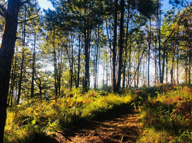
We commenced our hike at around 05:30 in the morning. The sun was almost up at that time, illuminating the concrete road we were walking on. We were hiking at the side of highway. Sea of clouds can be seen from afar, covering the view of Baguio City and other towns from below. We walked for about 10 minutes until reaching the trailhead proper. There, we were greeted with an ascending concrete path that made us pant early on in the hike. Good thing was that it only stretched for a few meters. Pat was already panting and catching her breath at that time. Nabigla ang mga baga namin.
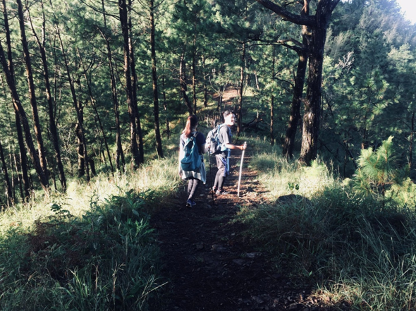
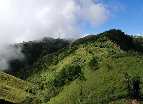
The ascending trail continues until reaching a viewpoint where a makeshift pictorial studio was built. Here, one can view the prominent Mount Santo Tomas, another mountain that can be hiked near Baguio City. We only spent a few minutes in that area because it was getting crowded. We continued our ascent. Pine trees were scattered everywhere, giving it the classic Cordillera vibe. The ascents were gradual, and the trail was very easy to walk on. We stopped over at a ‘mini-Gungal rock’ at the side of the trail and savored the view. Pine forests stretched at the side of the ridge towards the nearby mountain range – what a beautiful sight to see. Pat’s father was really enjoying the quietness and serenity of the place – something that he had always craved — an avenue of escape from the business and noise of the bustling city.
We continued our very long walk towards the first peak – Ambanaw Paway. We exited the pine forest, reaching the upper part of the ridge where grassland slopes were waiting for us to tread on. We reached Ambanaw Paway at around 07:30 in the morning. There, we had a very long rest. I lay down at the side of the ridge where Mount Santo Tomas can be viewed. The famous towers that are at the summit of that mountain can already be seen at this point, as well as the two radars that are thought to be two huge electric fans that give Baguio City its cool breeze.

The view in Ambanaw Paway is just spectacular. As mentioned, Mount Santo Tomas can be viewed to our right which is west. West Philippine Sea can be seen in the southwestern view. The southern part offers a view of the Central Luzon plain, where a distant Mount Arayat can be seen along the horizon looming in the middle of the field. I realized how lonely Mount Arayat was in its place. To our left (east), Mount Ugo stands prominently from afar. I still have to conquer this mountain very soon. Rotating my view to the left of Mount Ugo is of course, my very first Cordillera hike, Mount Purgatory. I was uncertain if it was Mount Pack of Mount Komkompol, but I was certain that it was the area of Purgatory because of its almost equal height with Mount Ugo. As mentioned in my earlier write-up, Mount Purgatory is just south of Mount Pulag, but I cannot seem to have a sight of Pulag at that time because of the thick puffs of clouds covering it.
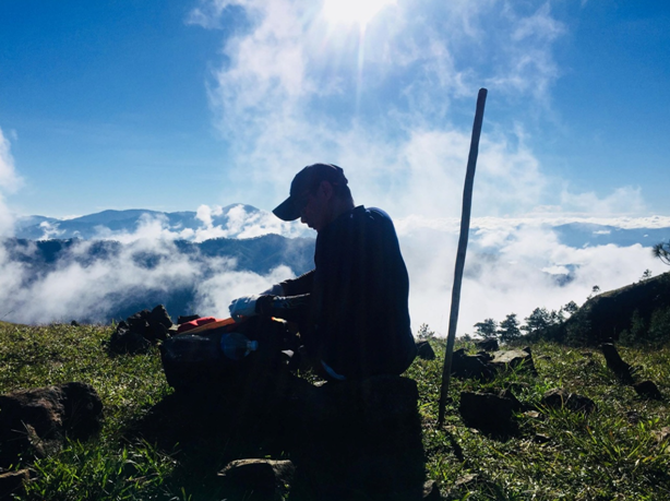
This was probably the longest rest I had during a hike. The morning dew, the sunrise breeze, the spectacular mountain views were all worthy of seeing for a significant amount of time. We continued our hike towards the ridge. The sun was now up, the sky was blue, and the clouds, although far, were around us. The heat of the sun was getting in our system as we tread along. The hike towards the second peak, Gungal Rock, was a long one. We had a lot of rest stops in the middle of the trail with no sun cover. No tall grasses, no pine trees, just a dusty and somewhat rocky footpath were presented to us as we went along with the hike. We reached Gungal Rock at around who-knows what time it is. That was sort of exhausting. Cool breeze who?
Gungal Rock does not look like what it seems to be in Facebook pictures. It was just a protruded rock at the side of the ridge. The famous rock where hikers take their pictures was surrounded by giant boulders where one can rest and take their lunch. Each of us took photo opportunities on the rock. Mount Santo Tomas serves as a picturesque background for the pictures.
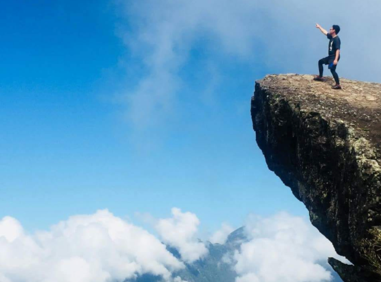
We continued our hike towards the third and actual summit of Mount Ulap. The summit area can already be viewed from Gungal Rock. We descended towards a rolling hill, and then ascending again towards the summit. The view reminds me of those Batanes and New Zealand pictures scattered on the Internet. The final assault towards the summit is a steep ascent on a grassland hill. Exposed to the heat of the sun, we rested in the middle of that hill because of exhaustion. Reaching the summit, we only had quick photo ops and descended towards the other side of the mountain.
Cows can be seen at this part of the mountain, where the trail eventually leads to a descending path that consists of makeshift wooden steps, serving as support ladders on the steep descent towards the bottom of the hill. Clouds were now nearing towards the trail. It eventually caught up and covered the view. The cool breeze was such a comfort after the scorching heat of the sun. Upon reaching the bottom of the hill, we rested for a while until continuing the descent towards the “7-11” sari-sari store in the middle of the forest. We rested there and took our lunch. We ordered instant pancit canton and a comforting Coke to soothe our hunger and thirst. We also waited for the middle and last group to arrive.
We descended before 1PM, leaving the middle and last group at the sari-sari store. The trail starts by passing through the ridge side, where to our right is a cliff where one can fall down. We then entered a pine forest, wherein the trail is a continuous descent. We treaded on mini ridges scattered with pine trees. It took us almost more than an hour descending that trail. The descending path ended, arriving at the foot of the mountain where we passed by fruit plantations, several houses, and almost three hanging bridges, until exiting through the highway where our van was waiting for us. Bathing areas were present in the area.

We took our baths and eventually left Barangay Santa Fe at around 4 in the afternoon. We passed through Barangay Ampucao heading towards Baguio City. Since it started to rain, we did not opt to go to Baguio for a side trip. We only had a quick stop at a souvenir store at the side of Marcos highway, and left Baguio going home.
Overall, it was a very satisfying hike. I was happy I was able to introduce hiking for Pat’s family. I am now hoping that they would pursue this endeavor. The trails are happier when we are with our loved ones, hehe. ‘Til the next hike!
Itinerary
Day 0
09:00PM Meet-up at McDonalds Greenfield District, Shaw
10:00PM Departure
Day 1
03:00AM Early breakfast at Leeza’s in Sison, Pangasinan
05:00AM Arrival at Barangay Ampucao
05:15AM Orientation
05:30AM Commence hike
07:30AM ETA Ambanaw Paway, rest
08:30AM Continue hike towards Gungal Rock
09:30AM ETA Gungal Rock, rest, photo ops
10:00AM Continue hike towards Mt. Ulap summit
11:00AM Summit
12:00NN 7-11, lunch
01:00PM Descend to Barangay Santa Fe
02:30PM Exit, take bath
04:30PM Sidetrip Baguio
09:00PM ETA Bulacan; home
