It was the end of September and I was finding a celebratory hike for ending an endeavor I was in. As I have joined numerous events by The Chill Trekker starting with my first major climb in Arayat back in April, I secured my slot in their Binacayan-Pamitinan twin hike scheduled specially for a certain group on September 29, 2018. As a first timer climbing the Wawa Mountains, I felt a bit of excitement and easiness with the hike. It was my first southern hike for the year, as my hikes have recently occurred in the north.
Dubbed as the Wawa Trilogy, Mount Binacayan (424+ MASL; pronounced as “binikayan” by the locals) is one of the three mountain gorges that stand tall in Barangay Wawa in Rodriguez (formerly Montalban) in Rizal, together with Mount Pamitinan (426+ MASL) and Mount Hapunang Banoi (517+ MASL). Legends say that Bernardo Carpio, a mythical figure in Philippine folklore, split the gigantic rock that formed the two gorges of Binacayan and Pamitinan, and between them is today’s Wawa Dam.
Sir Dandy, Ma’am Jaayem, and I met the group at McDonald’s in Panay Avenue at 1 o’clock in the morning. It felt weird not seeing these guys at the busy centre of Greenfield District where we usually rendezvoused with our hiking trips. The group we met was a company barkada that contacted The Chill Trekker for their company outing. They endorsed the trip to the public mainly because they needed another person to fill in the slot so that the hiking fee would not increase. Apparently, I was the only one who was interested to join. Bahala na.
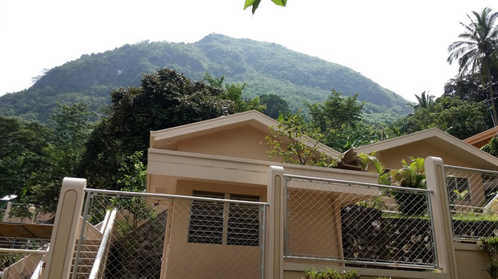
We arrived at Barangay Wawa sometime around 2 in the morning. It was still dark, but the area was already filled with local officials and other hikers. Hiking activities, according to the officials, start at 4am, so we waited and chitchatted. Dandy and I ate our breakfast at a carinderia nearby. Minutes passed and hikers were already flocking the area. We even saw and greeted Lourd De Veyra! By 4, our contacted guides arrived and we commenced the hike 30 minutes after. On to the gigantic rock!

The trail to Mount Binacayan starts on the main road outside of the barangay hall. Going straight leads to the trails of Mount Binacayan; on the left side of the road is Wawa River, which is the trailhead proper for Pamitinan and Hapunang Banoi. As you go straight towards the road, an ascending pavement will greet hikers dotted with houses and other structures until it ends on a trailhead. This ascending portion is already a part of Mount Binacayan. As you go along to the trail proper, rest stations, which are actually houses of locals inside the mountain, are placed strategically so that beginners may have ‘breathers’ after that ascending warm up. The trail, then, leads to flat to gradually ascending portions inside a forest. Hikers may experience a foggy surrounding at this part because of a gain in elevation. This is an indication of a possible view of sea of clouds above the mountain. Once you have gained elevation, Mount Parawagan, another mountain in Wawa, dominates the view to your right. Behind Mount Parawagan is Metro Manila with bright orange hues illuminating the dawn.
A gigantic rock wall marks the end of the forest trail, and the start of the rock scrambling portion towards the summit. We treaded along limestone formations with very sharp surfaces. Gloves must be used as a precaution to the hand. The trail was easy to moderate when it comes to its difficulty level, but it felt a bit frustrating because of the sharp and hard surface that you need to scramble on. After an hour of scrambling, we reached a vantage point where a view of the sea of clouds was present. We savored the view and the group actually wanted to take their long break there but the guide suggested a much grander view at the top.
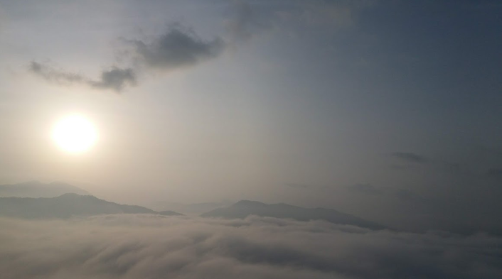
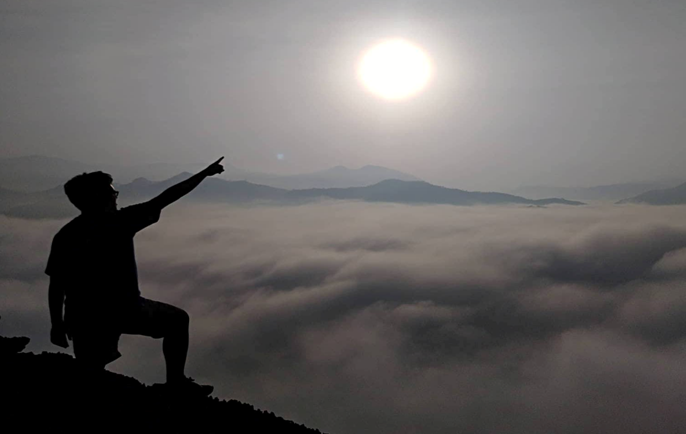
We headed towards what the guide called as the ‘dinosaur peak’ – a gigantic, Tyrannosaurus-like boulder near the summit where the view of the clouds was magnificent. Facing east, the sun rises at the sky, complementing it with the sea of clouds below. Several mountain peaks were also peaking above the clouds from afar, as if saying hello to fellow hikers that they need to be discovered too. This was my first time to see a nearby sea of clouds. We rested there for more than an hour, taking the opportunity to have some cool shots with the sea of clouds. We also took our breakfast there. I munched on my bananas – wow healthy living???
After an hour, we marched towards the summit facing north. Limestone rocks dominated the whole trail, until ascending to a bamboo forest where gigantic rocks are still scattered throughout the surrounding. After a few minutes, we reached the summit – a giant limestone formation atop of the whole mountain. The summit area was flocked with hikers. We waited for out turn to climb the limestone formation. While waiting, we explored the area and found great vantage points where we can take pictures. To our east (right), a view of the Wawa River snakes through the ground until disappearing in the bosom of the mountain ranges nearby. The sea of clouds has now dissipated, and haring araw was now making his presence felt.
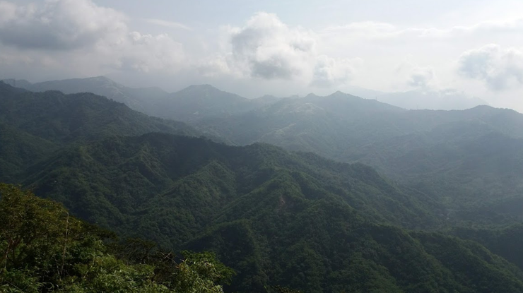
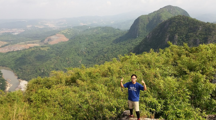

A few hours of waiting and hikers seem to gradually disappear. We had the summit area to ourselves when we climbed the limestone formation. The view there was fantastic! To our north was Mount Pamitinan, and then Mount Hapunang Banoi behind it. Behind those two mountain gorges was a familiar pointy peak – Mount Ayaas (627+ MASL), which JM, Dex, Marco, Ma’am Celine and I climbed last October of 2017. Beyond Mount Ayaas, Bulacan’s Mount Balagbag can be seen. On clearer days, Mount Arayat can also be viewed from afar. To our west (left), Mount Parawagan stands tall, behind it is Metro Manila, and beside it is the town of Montalban. I was a bit sad to see a quarrying area near the foot of Parawagan. To our south, we saw another mountain gorge which is Mount Lagyo and behind it, although obscured was Mount Susong Dalaga. Mounts Parawagan, Lagyo, and Susong Dalaga are famously known as the ‘Wawa Trilogy version 2’ – a newly opened hiking spot that introduces hikers to the other mountains of Barangay Wawa.
We descended Mount Binacayan using another trail that eventually leads to the resting stations at the initial part of the hike. Descending the limestone rocks was just as frustrating as climbing it. This part of the climb was strategically made for descending Binacayan because of its westward direction, wherein sunlight still has not penetrated that side of the mountain. This portion, however, was a lot steeper than the ascending part. Rock scrambling was more technical at this section of the mountain, and careful negotiation was really a necessity. Upon reaching the rest stations, we found locals selling buko juice and grilled hotdogs. We took the chance to savor those. After a few minutes, we continued our descent. I expedited my pace on the forest trail, which then led to the pavement going towards to the barangay hall. Another mountain completed!
As our companions were first timers, they were tired and did not opt go for Mount Pamitinan. We rested and ate our lunch at a nearby carinderia and decided to just go to Carugo Falls, which is situated in the same barangay. At around 1PM, we decided to start the hike towards the falls.
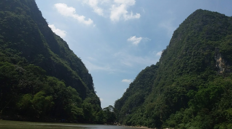
Going there, we passed by Wawa River and the famous hanging bridge that leads to Pamitinan and Hapunang Banoi at the other side of the river. We treaded along a makeshift cemented path at the foot of Mount Binacayan. We, then, passed by Wawa Dam. Gigantic boulders were scattered below it, reminding me of our childhood trips in Madlum in San Miguel, Bulacan. We walked further until reaching the back of Binacayan and Pamitinan. We crossed a river using a boat and river-trekked until reaching Carugo Falls, which was sadly a bit dry at that time. We then ascended the falls until reaching a lagoon where we bathed for an hour.
Going back to the barangay hall where the local community was alive at that time, we tidied ourselves and went back to Quezon City at around 4 in the afternoon. What an unforgettable adventure! Although it was a letdown that we were not able to climb Pamitinan, I will surely go back to climb it together with Hapunang Banoi. Completing the Wawa Trilogy is now on my bucket list, together with trying the version 2 sometime soon. The province of Rizal has opened a lot of mountaineering hotspots recently, and although I am still not interested in climbing those yet, I am surely going to go back to Wawa, as well as to Mount Sembrano in Pililla to complete my unfinished business with them!
Itinerary
01:00AM Meet-up at McDonald’s Panay Avenue
02:00AM ETA Brgy. Wawa, Rodriguez, Rizal
02:40AM ETD Brgy. Wawa; breakfast
04:00AM Orientation
04:30AM Start hike
05:45AM ETD Dinosaur Peak, rest, photo ops
07:00AM Commence assault to summit
07:30AM ETD Summit, rest, photo ops
09:00AM Start descend
10:00AM Rest at the junction (rest stops), eat and drink
11:00AM Back at the barangay hall, lunch
01:00PM Hike to Carugo Falls
01:30PM Picture taking at Wawa Dam
02:00PM Arrival at Carugo Falls
03:00PM Head back to barangay hall, tidy up
03:45PM ETD for Quezon City
04:30PM ETA Quezon City

One thought on “Mt. Binacayan Day Hike (424+ MASL)”