Walang Umayaw sa Amuyao!
Last August 26, 2018, I scaled one of the grandest Cordillera mountains – Mt. Amuyao. Rising at an elevation of 2702 meters above sea level (MASL), it is the fifth highest mountain in Luzon, just behind Pulag, Tabayoc, Timbak and Kalawitan. It is also included in the top 20 highest mountains in the Philippines and was included in the top 10 before being displaced by Kalawitan and several mountains in Mindanao. The grand mountain proudly stands tall in Mountain Province’s highland topography. It is situated in the town of Barlig. It can also be accessed through Batad and Mayoyao in Ifugao, and is considered as one of the greatest traverses in the Philippines. Sadly, the Barlig-Batad traverse (or vice versa) closed in the summer of 2018 due to conflict of interest between the two towns. Still, the mountain can still be accessed through Barlig and is still considered a difficult hike on its own.
So how did I end up in Amuyao? It was 2018 and I have ventured to some of my first major climbs, starting with Arayat in April, Purgatory in June, and Tarak Ridge in early August. I was once again planning on climbing since it was a long weekend in observance of national and local holidays here in Bulacan. I also was not able to climb on my birthday for unforeseen reasons, and this made me itch for another walk in the jungle. Scouring through Facebook’s noisy Climber page, I found a gem – one that every hiker rarely finds but evokes a sense of relief to our minds and pockets – a DIY budget-friendly climb! Who would have thought that I could find something as rare as a DIY budget-friendly climb in the northern, 6-hour-ride-from-Baguio town of Barlig? We expressed our interest and informed the organizer that we were joining. What came next was practically one of my best climbs ever – an unforgettable adventure coupled with meeting some of the most spontaneous people.
The group met at McDo in Panay Avenue at around 3 o’clock in the afternoon of August 25th. JM, my passionate college buddy, and I met them at around four in the afternoon in Sta. Rita exit in Guiguinto, Bulacan. It was a 3-hour ride before we had our dinner along Pangasinan. The driver opted for the route in Baguio because of the heavy traffic in Santa Fe in Nueva Vizcaya. We were in Baguio at around 9 in the evening. What came next was one of the longest and most terrifying rides of my life. Past Baguio, we entered Halsema highway – the highest highway system in the country. The highway connects Baguio to the other towns of Benguet and Mountain Province. It was still practically a 6-hour ride from Baguio to Barlig from there. What we witnessed in Halsema were terrifying giant boulders from landslides, floods along the highway, falling debris at the side of the road, and giant road blocks we had to cross through. There was even a truck submerged into the soil from the landslide! Witnessing these made me realize that not being able to sleep through car rides really has its downfalls. We made it to Bontoc around four in the morning after several hours of negotiating through the tough road. It was still an hour before reaching the town of Barlig.
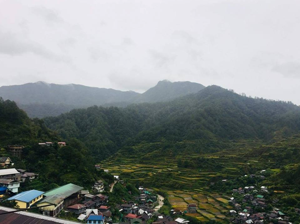
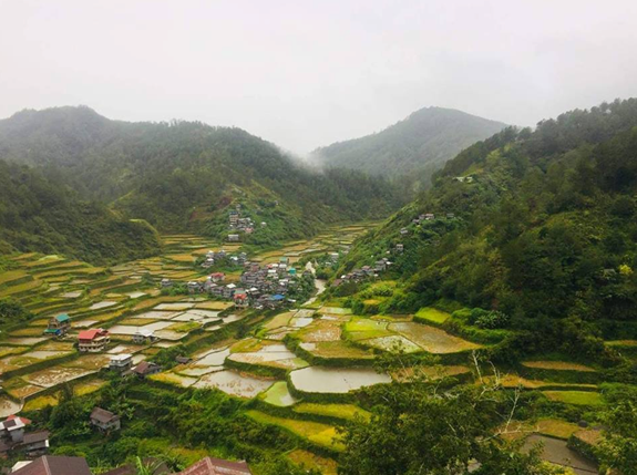
We reached Barlig at around 5 in the morning. No one welcomed us in the municipal hall but heavy rains, barking dogs, parked vehicles, and pretty much nobody. We waited as sunlight started to appear. We were 5 hours delayed from our itinerary and the events of the day were still unknown. By 6, Barlig’s policemen started to wake up and offered us a cup of coffee and a jar full of cookies. They were discouraging us from climbing since it was raining very hard and most of their guides were either drunk or were already inside the mountain with other hikers. We were now considering other options. Mts. Fato and Kufafey in the nearby town of Bontoc came into mind, but the group’s persistence did not falter and we somehow negotiated with the local authority to push through with the climb. Risky – yes – but nonetheless persistent; despite being a ‘responsible-mountaineer’ advocate, I still wanted the climb to push through, knowing that the trail would be somehow easy to negotiate since it had non-technical portions and it really just was a flight of stairs up until the summit. Finally, the local police succumbed and permitted us to go with the climb. However, we waited for a good 2 hours before our guide arrived. We pretty much chitchatted and enjoyed the mountainous view of Barlig while waiting. The summit of Mt. Amuyao could already be seen in the town proper. Under it is a dense forest with rice terrace. Directly below these forested slopes and rice terraces is Barlig’s town proper. By 09:45 in the morning, our guides arrived and we started the hike to Luzon’s fifth highest summit.
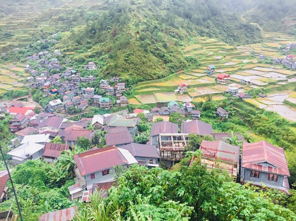
The trail starts in Barangay Macalana after going down the stairs from the municipal hall. There, we shortly met with the barangay captain. Past Macalana, we passed through some stairs leading to the rice terraces. I was surprised how high the terraces were apart from each other. It would at least be an 8 to 10 feet fall if you lose your balance. Past the rice terraces, the real trail now ensues.
It really was a flight of stairs with no flat surfaces that made up Amuyao’s trail. My pace was seriously slowing by the minute as I was panting from the heavy cardio-workout. Wearing a heavy poncho was also taking its toll on me. Screw it! I took off my poncho despite the light rain and risked getting wet with my cloth jacket and my t-shirt and arm sleeves as my base layer. Luckily, the rain stopped as we were negotiating the tiresome flight of stairs.
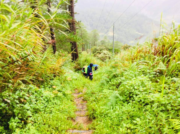
Surrounding the established trail were pine trees and several plants on the side. This was one of Amuyao’s distinctions from the other Cordillera mountains – it had a variety of shrubs and flora that go along with the pine trees, sometimes blocking the view of the surrounding forest but giving a garden-like feel as you climb along the stairs. An hour from the jump-off took us to a generator. What the hell is a generator doing in the middle of the trail? Well, added trivia: the summit of Amuyao houses transmission towers of a certain media company complete with a bunker and several structures. The Barlig trail is practically an access to those towers and the summit itself, so it is dotted with electricity posts as you go along. You’d never get lost in the mountain because you can just follow the electricity lines going up.
We had a quick break by the generator. We hurriedly munched peanuts and had a quick water break. Our companions were harkors so a take-5 rest on major climbs happens only once or twice for the entire climb. Past the generator, we entered a mossy forest. The trail was relatively flat to gradual ascending. It was a relief for the knees from an hour of negotiating from the initial parts of the trail. Still, the tiredness was felt and I had a hard time catching up. An ascent once again starts, until reaching the half-point of the climb – a waiting shed in the middle of the dense forest. It was 2 hours after starting from the trailhead, and it was still a good 2 to 3 hours from the waiting shed up to the summit.
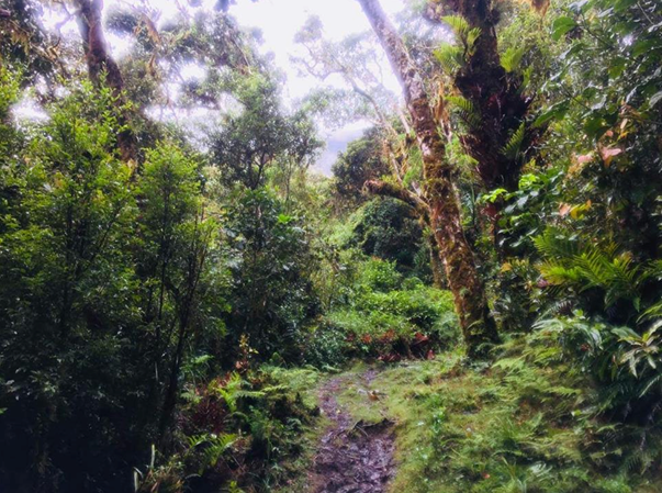
JM and I were in sweeper/last group. The rest of the group went ahead as we were having a take-5 on the waiting shed. We munched on bananas – a good ol’ trail food that is healthy for the knees. And nope, it sadly did not save me from the pain brought by Amuyao’s steep assaults. The trail after the waiting shed was a steeper set of stairs compared to the initial ones. And yup, the trail was pretty long. A makeshift steel ladder was even built near the waiting shed because the assault was that steep. This was seriously one of the slowest pace I had going up, but not as slow as when I was an 11-year old climbing the scorching Mt. Pundaquit with a full pack. At least in Amuyao, it was cold, saving me from dehydration. Thank God for the endurance built from my previous hikes. This section reminded me of Tarak Ridge’s steep assaults after taking a break from the halfway point in the trail (Papaya River). The only difference was you cannot use your arms to negotiate with the trail. In Tarak, I had to use all four limbs in climbing the steep assaults and this was seriously a big relief for my body. In Amuyao, the burden is solely (and painfully) put through your legs. Because we were also inside a dense forest, and it just rained, some of our companions had limatik bites. I actually saw one in my finger but I was able to quickly remove it.
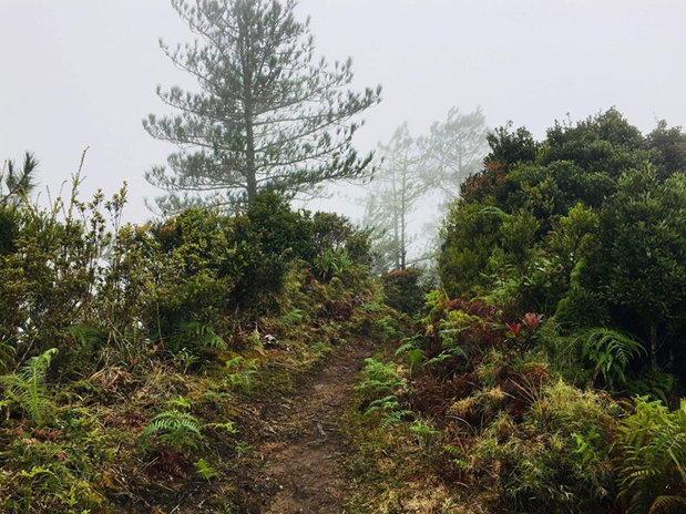
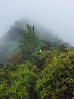
After an hour of a painful negotiation with the steep assault inside the dense forest, the trail unfolds into a beautiful garden-like milieu that is different from the ones we encountered at the foot of the mountain. Several floras can be observed along its trails, and what we were treading on was a wide ridge in which one could fall down from both sides. The summit area and its towers were now visible to our right, but we knew it was still far ahead. Just an hour left before reaching the summit! Despite the view being somehow obscured by clouds, we could still see the mountains below. It was amazing. Imagine if we hiked on a sunny day, the view would probably be spectacular. Minutes of walking, we passed by a water source. We refilled our bottles and had a mini break. After that, we needed to assault another flight of stairs to the summit. I was seriously becoming impatient at this point because I was hungry. I was getting weak with every step and I could already feel my knees throbbing in pain. One accidental slide and I’m seriously gonna feel cramps. When I saw the gate that says “Welcome to Mt. Amuyao”, I was relieved! Finally! The assault is over! Four and a half hours of climbing and we were now at Luzon’s fifth highest summit!
The summit area, again, houses transmission towers. It had a cemented terrace where the bunker resides. We had no clearing at that time because of the rain earlier. Everyone did not seem to mind. We rested and had our lunch inside the bunker. I put down my wet cloth jacket to save myself from hypothermia as it was really, painfully cold outside. The biting surrounding was a lot more excruciating to the skin as compared to what we experienced in Komkompol (Purgatory’s highest at 2300MASL). Our companions informed us that this was nothing compared to Pulag’s. Now I’m scared AND excited to climb Luzon’s grandest.
It was 2pm when we decided to take pictures (while shivering) and go down. Since it had an established trail where I could go down fast, I considered tagging along with the lead group. But alas, the inevitable happened and I stumbled while climbing down which resulted to very painful cramps. Luckily, one of my companions applied the very familiar treatment of stretching the muscles while sitting down. I let the others pass through and just go along with being a sweeper again.
Slowly, I was making my way down through the heavy forest. The trails were slippery and we had to be careful with every step. The trail being a staircase really helped a lot in preventing us from slipping as long as we go slowly, but it was also painful to the knee. After reaching and going down the makeshift steel ladder, adrenaline kicked in and I rushed through the mossy forest. We were seriously far away from the rest of the group, but I was really getting tired and satiated from the trail. “Go down, so go fast,” says my brain. And I seriously did. I somehow left JM and two others to expedite my pace. I was seriously walking fast and there I realized how really long the trail was. Walking alone in the mossy forest, I was shrugging the feeling of creepiness while passing through the trail.
And alas, I caught up with the middle group. We were now outside the mossy forest. They gave me a look of surprise when they saw me, but did not bother to utter any words. They were tired too, probably. We reached the generator and there, the middle group rested. I considered waiting for JM at this spot but screw it! I passed by the middle group and made my way down very quickly. Wow, where was this energy when I was going up? Passing through the pine forest, I caught up with the rest of the ‘middle-lead’ group. I offered them my untouched snacks – my secret weapon – Lychee jelly ace! After that, I again expedited my pace, leaving them behind. I was panting at this point because the stairs did not seem to end. The town of Barlig was now visible at this point. I can also see the lead group from afar.
After several minutes of enduring the way down, I caught up with the lead group in the rice terraces portion of the trail. They were pretty shocked how fast I caught up to them. They were posing for pictures in the middle of the rice terrace-trail where they could seriously fall down if they weren’t careful. All of us had our knees shaking just by standing on the terraces. Before entering Barangay Macalana, we waited for the others to catch up. It was around 4 in the afternoon. We took pictures and had our rest. When almost everyone caught up, we made our way to Barangay Macalana and climb (again) the stairs going up to the municipal hall.
I reached the area near the municipal hall where our van was waiting for us at around 6. Our companions were inside a cafeteria resting. The others were taking their baths. After a few minutes, JM arrived. He was alone. He probably expedited his pace too. We had a post-climb dinner and drank dark chocolate. Our companions were considering spending the night on a homestay since the police informed them that there were landslides along the way to Bontoc. It was our turn to take a bath when they announced that the roads are now safe and it is now passable to vehicles. Our companions hurriedly went to our vans, while I hurriedly went to the bathroom. Ah, hot water on my skin – sarap.
And there we were, leaving Barlig after an exciting, spontaneous adventure on the beautiful trail of Mt. Amuyao. After Bontoc, we passed through Ifugao going down to Nueva Vizcaya to take the Santa Fe exit. Upon reaching Vizcaya, we had a celebration dinner. Thanks and happy birthday to Ma’am Zil – our persistent organizer who had the spontaneity to push the climb whatever it took! We reached Malolos at around 5 in the morning the following day. What an adventure.
Another mountain checked off my bucket list! Mt. Amuyao proved to be a painful yet elegant mountain with garden-like scenery that sets it apart from the rest of the Cordillera mountains. Its unique flavor of pine and mossy forest complete with a variety of flora establishes its identity as a mountain worthy of being climbed and explored. It would be an honor to someday hike the grand traverse from the Batad side. Someday.
Itinerary
Day 0
03:00PM Meet-up at McDo, Panay Avenue
04:00PM Sta. Rita Exit, Guiguinto, Bulacan
07:00PM Dinner in Pangasinan
09:00PM Baguio City, enter Halsema highway
Day 1
05:00AM Arrival at Barlig, breakfast, coffee
09:45AM Start hike
10:00AM Generator area, enter mossy forest
11:00AM Half-point of hike; waiting shed
01:30PM Summit, rest
02:15PM Start descend
04:30PM Rice terraces, photo ops
05:30PM Barlig town proper, eat and rest
07:30PM Departure from Barlig
11:00PM Dinner along the way
Day 2
05:00AM Arrival in Malolos, home

2 thoughts on “Mt. Amuyao via Barlig | Luzon’s 5th highest at 2,702+ MASL”